Incoming Tropical Rains Target South Florida
Forecast models hem and haw on development odds but a prolonged period of heavy rain is in store for parts of the Florida peninsula regardless

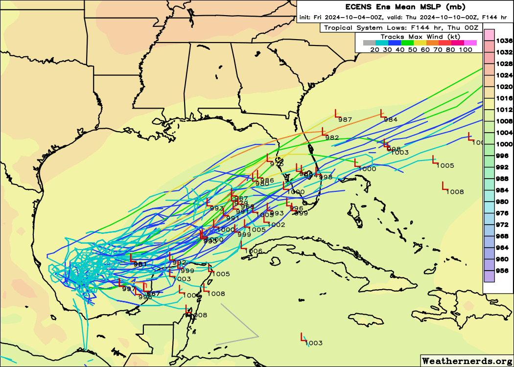
A broad area of low pressure and storminess we’ve been tracking over the Gulf of Mexico this week is expected to bring persistent rounds of heavy rain to much of the Florida peninsula – including across South Florida – beginning in earnest on Sunday and lasting through much of next week.
As much as 7 to 10 inches of widespread rainfall is expected through next Friday, with some areas exceeding over a foot of rain locally. While the exact timing and details of the heaviest rain will depend on where the low pressure moves and how organized it becomes, areas from the I-4 corridor between Tampa and Daytona Beach southward through the Florida Keys will be at highest risk for potential flood issues next week.
Of the past 142 days (since mid-May) in the Miami area, 130 of them have seen high temperatures of at least 88 degrees (112 days at 90 or above), so high temperatures in the mid to even low 80s next week will be one added benefit of the cloud cover. The relief from the heat won’t come without an increasing threat for flooding, which we’ll need to monitor in the days ahead.
Complicated development scenario
As we discussed in this newsletter on Monday, the area over the Gulf is broadly associated with the Central American Gyre – an elongated area of spin and storminess stretching from the eastern Pacific into the western Caribbean.
Earlier in the week, models were honing in on the eastern piece of this broader Central American Gyre from the western Caribbean that’s since pivoted over the south-central Gulf.
In recent days, however, the models have latched on to the remnants of Tropical Depression 11 from the eastern Pacific instead that’s crossing southern Mexico and forecast to emerge over the southwestern Gulf of Mexico this weekend. It’s this piece of spin farther southwest that’s now forecast to be the dominant focus of any tropical development next week.

The shift from the northeast lobe to the lobe farther south and west gives the disturbance a little more runway beneath hostile upper-level winds to the north to try to take shape.
For now NHC gives the area a medium chance of formation, but whether a tropical (or subtropical) depression or storm forms next week, the upshot will be heavy rainfall and the possibility of minor to moderate coastal flood issues along Florida’s Gulf Coast.
Open Atlantic on a tear
As we discussed yesterday, the deep tropical Atlantic is unusually active for October.
Kirk is now a large and extremely powerful Category 4 hurricane, with some reliable satellite estimates suggesting it could’ve touched Category 5 status early Friday morning.
Although Kirk will turn out to sea, as we discussed earlier this week, long-period swell from the hurricane will reach the U.S. Eastern Seaboard by Sunday into Monday which will increase the risk of dangerous rip currents along area beaches.
Behind Kirk, Leslie is slowly strengthening. While Leslie has been limited by wind shear from Kirk’s extensive outflow, as Kirk accelerates northward this weekend, the shear should relax and Leslie is forecast to grow into the Atlantic’s 8th hurricane of the season in the coming days.
Thankfully like Kirk, Leslie is expected to remain over open water during its time as a hurricane.


Glad Kirk and Leslie are going to be fish storms,, no one needs that horror. I see we are going to get dumped on with a lot of rain, just hope that is all we get.
Seriously, thank you for your analyses.