Tropical Depression Four Forms, Hurricane Watches Hoisted for Florida's Big Bend
Squally weather and rounds of heavy rain expected for today into Sunday across South Florida
Late on Friday, the strong disturbance dubbed Potential Tropical Cyclone Four earlier in the day by the National Hurricane Center finally gained enough organization south of Cuba to be classified a Tropical Depression.

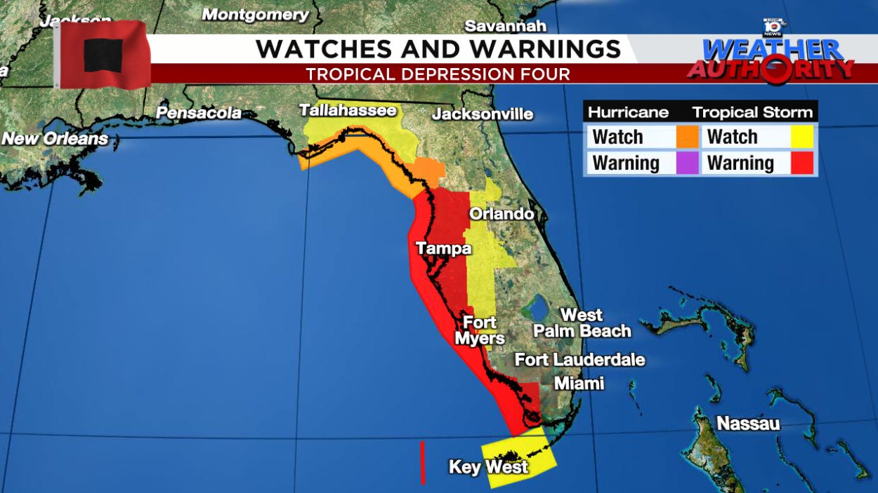
By Saturday morning, hurricane watches had been issued for Florida’s sweeping Big Bend, from just west of Apalachicola to near Crystal River.
Though the system is in its early development stages – with thunderstorm activity gradually building over its newly formed circulation center – as it pulls away from Cuba later today and clears land impediments that have stymied development until now, it’s expected to strengthen into Tropical Storm Debby tomorrow and possibly Hurricane Debby over the eastern Gulf before moving ashore Monday.
Hurricane watches issued for Florida’s Big Bend
A hurricane watch is in effect for Florida’s Big Bend from just west of Apalachicola to just south of Cedar Key, including St. George Island, St. Marks, and many areas of Apalachee Bay affected by Hurricane Idalia last August. A hurricane watch means hurricane conditions (winds of 74 mph or higher) are possible, with tropical storm conditions (winds of 39 mph or higher) arriving within the next day or two.
A tropical storm warning is in effect for the entirety of Florida’s Gulf Coast south of the hurricane watch, including places like Tampa, Sarasota, Port Charlotte, Fort Myers, and Naples. A tropical storm warning means winds above 39 mph are expected within the next 36 hours.
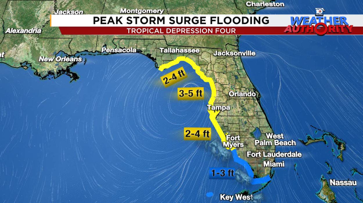
As the wide winds of the organizing storm push into the eastern Gulf tomorrow, coastal flooding will be an issue, especially from near Fort Myers northward, with the highest threat from the Tampa Bay area through the broad arc of Florida’s Big Bend.
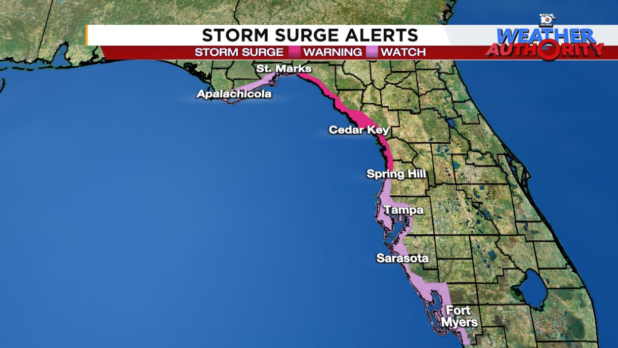
For now, the forecast calls for 2 to 4 feet of possible flooding from storm surge into Charlotte Harbor and Tampa Bay to the south and up to 5 feet into the Big Bend from Crystal River and Cedar Key north to near St. Marks. Up to 4 feet of storm surge flooding is possible from near St. Marks westward to Apalachicola.
Much of Florida’s Big Bend is now under a storm surge warning for the danger of life-threatening storm surge in the next 36 hours.
The exact details of the storm surge are dependent on a variety of factors, including storm size and angle of approach to the coast, that can be more difficult to pin down with a developing storm approaching Florida at an oblique angle. Subtle deviations in track to these storm-surge-prone areas can produce meaningful changes to the coastal flooding. Always check back for the latest NHC forecasts.
Flood threat stretches from Florida into the Carolinas next week
One of the concerns we discussed beginning in Thursday morning’s newsletter was a possible slowing or even stall of the storm early next week as it moves inland across north Florida, southeast Georgia, and the Carolinas.
Our models continue to advertise that possibility by Monday and lingering into Wednesday or Thursday as future Debby gets stuck in between two competing high-pressure steering zones. Depending on where this slowing happens, this could bring a significant, prolonged heavy rain and widespread flood threat anywhere from north of Florida’s I-4 corridor to areas along and east of I-95 through the Carolinas.
A 2023 study by the National Hurricane Center found that flooding from rainfall has been the deadliest calling card of tropical systems over the past decade, accounting for nearly 60% of all tropical cyclone related deaths in the U.S.
The development ceiling in the eastern Gulf is high
It’s worth reiterating that in many circumstances, especially in the early months of June and July, even when waters are warm, the ceiling for development is often capped by less conducive atmospheric variables, such as hostile wind shear.
This isn’t the case right now over the system and in the eastern Gulf, where a sprawling upper-level area of high pressure has created nearly ideal atmospheric conditions for strengthening.
As we mentioned in newsletters earlier this week, the waters in the northeastern Gulf are the warmest on record for the time of year, topping out at over 90 degrees Fahrenheit – some of the warmest waters right now anywhere on the planet.
This means we need to watch this storm carefully as it clears Cuba and gets into the Gulf tomorrow, as its development potential will be limited only by how much time it has over water to organize before moving inland sometime Monday.
Storms entering environments like this shouldn’t be trusted, even if they behave as we hope they will.
The bottom line
Waves of heavy rainfall and gusty winds will move through South Florida and the Keys today and into Sunday along the periphery of Tropical Depression Four. Winds have already gusted to 46 mph in the middle keys and 37 mph at Miami International Airport this morning. Widespread gusts to tropical storm strength are expected, especially with squally bands throughout the day. Rain totals for southeast Florida will generally be in the 2-to-5-inch range, with higher amounts which could lead to pockets of localized flooding into tomorrow. A few brief, weak tornadoes also can’t be ruled out over the next day or so.
The more serious threat from damaging winds and flooding in Florida will be along the state’s Gulf Coast, especially from Sarasota northward through Florida’s Big Bend. A hurricane strike appears increasingly likely somewhere along Florida’s Big Bend from Apalachicola to north of Tampa by Monday.

Folks in these areas should finalize preparations today and early Sunday, as tropical storm conditions could arrive by later tomorrow.
The threat for heavy rainfall and widespread flooding will grow into early next week as future Debby slows or even stalls across north Florida, southeast Georgia, or the Carolinas. A prolonged flood threat is increasingly likely deep into next week for these areas. We’ll have a better picture of this growing flood threat as the storm comes together in the next few days.


Update: It has already become Debby earlier than anticipated.