Potential Development Zone Shifts West, Putting Eastern Gulf in Focus
Rounds of blustery downpours with the possibility of localized flooding for South Florida beginning late tomorrow, but odds of an organized tropical threat for South Florida lessening
In Wednesday morning’s newsletter, we discussed how the interplay between the robust tropical wave moving through the complex terrain of the northeastern Caribbean islands today and tomorrow would be crucial to its forecast this weekend.
By late yesterday, we saw the outcome of this, with models honing in on the southern side, keeping it weaker in the near term, but shifting its possible development zone dramatically westward into the eastern Gulf of Mexico for the weekend into early next week.

In the endless war of the models, the European model – which had targeted the northern side of the wave, largely developing it east of Florida – blinked, caving to the American GFS which insisted on a weaker system sneaking past Florida and into the eastern Gulf. As a result, the National Hurricane Center’s development potential zone swung from east of Florida yesterday to the eastern Gulf of Mexico this morning.
While these forecast changes since yesterday are largely positive for South Florida and the southeast coastline, they aren’t so sanguine for the Gulf coast.
Rounds of blustery tropical downpours for South Florida this weekend
Entanglements with Dominican Republic, Haiti, and eastern Cuba will act as a speed bump to development in the short term.

While gradual organization is expected to the storminess into tomorrow, the system will likely remain an “open” tropical wave (a broad tropical disturbance without a closed circulation center) as it passes through or just south of South Florida on Saturday.
Beginning tomorrow afternoon, we can expect an increase in storminess across southeastern Florida as rounds of blustery downpours move in with the approaching wave. The waves of intermittent heavy rain and breezy conditions will tick up on Saturday and some of the downpours could produce localized flooding, especially along the urban corridor of I-95 where the rains aren’t as easily absorbed.
The messy weather may linger into Sunday, especially on the western side of the South Florida peninsula.
Worrying forecast factors for the eastern Gulf
In yesterday’s newsletter, we mentioned credible scenarios that took a weaker system or undeveloped disturbance into the eastern Gulf, a worrisome possibility for multiple reasons.
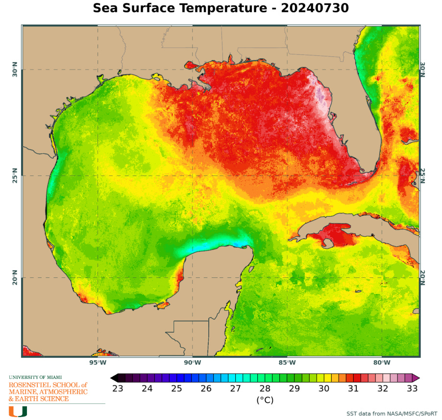
Sea surface temperatures in the eastern Gulf are warmer than any other part of the Atlantic right now.

As important, a sprawling upper-level area of high pressure is forecast to take shape across the eastern Gulf by Sunday into Monday, an important factor that we talked about on Tuesday.

This is a notably conducive upper-level pattern for potential strengthening, as wind shear will plummet underneath the upper-level high. It’s primarily a matter of how much time the system has to organize across the eastern Gulf this weekend.
The other concern is a potential stall as steering currents break down early next week. Depending on how far north it gets Sunday into Monday, this could spell a prolonged, multi-day heavy rain and flood threat for areas along the eastern Gulf or farther inland. We won’t know the details of this until the system comes together, but we’ll need to monitor these trends in the days ahead.
The bottom line
Forecast models have trended weaker in the short term, which has reduced the risk of an organized tropical depression or tropical storm into South Florida, although rounds of blustery downpours should be expected this weekend, especially on Saturday.
Forecast guidance – most prominently the European model – has shifted significantly west since yesterday, now indicating the possibility of tropical development over the eastern Gulf of Mexico this weekend. Conditions in the northeastern Gulf look largely conducive for development, so interests from southeast Louisiana to western Florida should check back often on the forecast over the next few days.
Tropical rainfall is historically one of the deadliest calling cards of tropical storms and hurricanes, and we’ll need to monitor for the risk the system stalls or moves slowly, worsening the rainfall threat as it approaches the Gulf coast Sunday into Monday.


Crap, well guess we will have to see what happens.
Thanks for the info. Will be watching from West Coast Florida.