Tropical Storm Watches and Warnings Issued for Parts of Florida
Models struggling with where Potential Tropical Cyclone Four forms and how quickly it moves inland, but heavy rainfall a growing threat regardless
On Thursday, the National Hurricane Center designated the strong tropical disturbance now moving across eastern Cuba Invest 97L, a procedural move that allowed NHC to begin running a specialized suite of computer models to better interpret its future strength and track.
By late Friday morning, although the system had yet to form into a tropical depression or tropical storm, its proximity to land prompted NHC to begin advisories on Potential Tropical Cyclone Four, allowing for the issuance of critical watches and warnings ahead of the developing system.
A tropical storm warning is now in effect for southwest Florida from around Naples southward, including Marco Island, indicating winds above 39 mph are expected in these areas within the next 36 hours. A tropical storm watch is also in effect for the Florida Keys and for the Gulf Coast of Florida from north of Naples to around Tarpon Springs north of Tampa, including Tampa Bay.
If a tropical storm forms as forecast this weekend, it will be named Debby.
Models struggle with formation
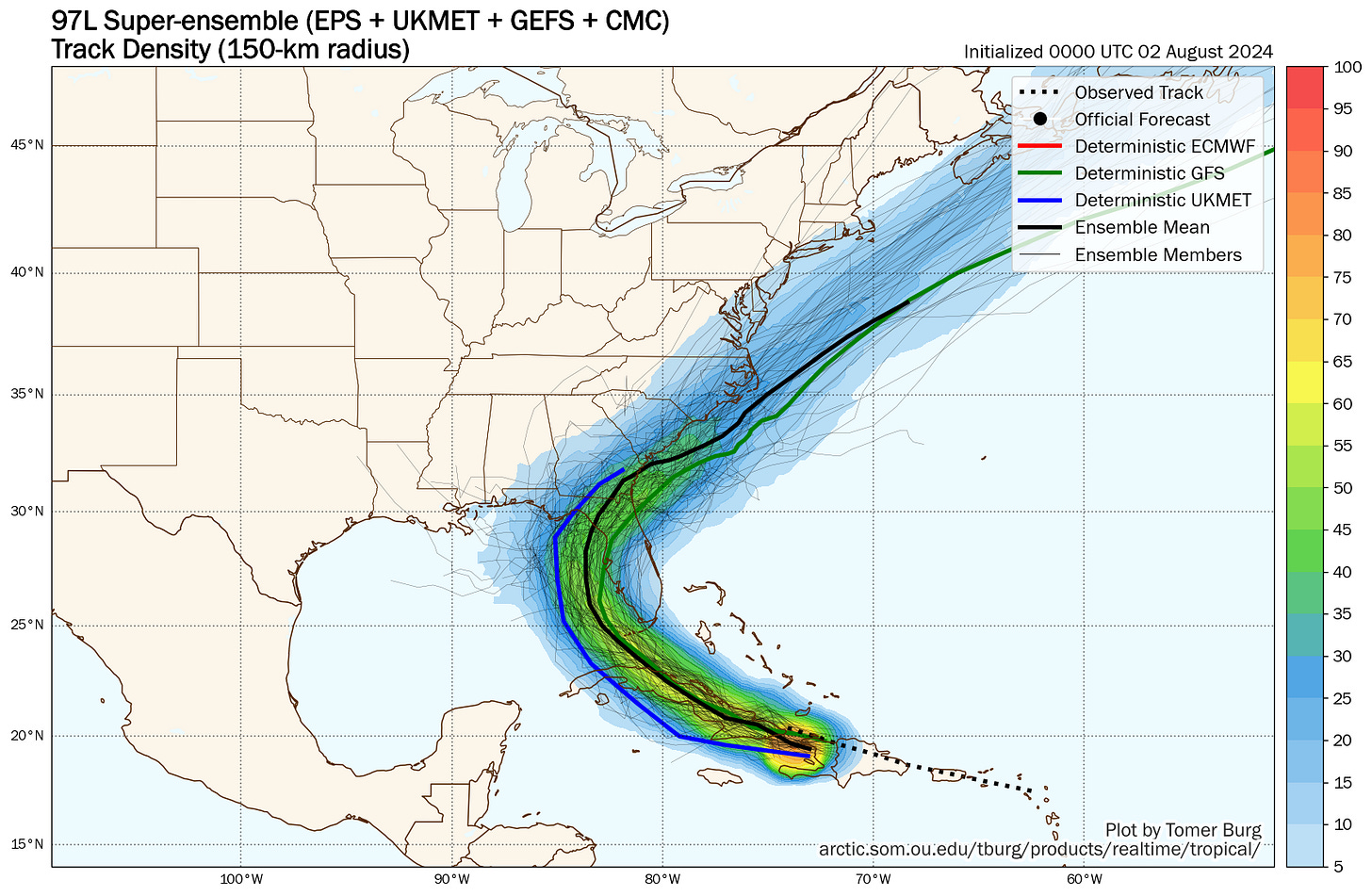
Modeling the exact details of the tropical wave’s interaction with the complex terrain of the Caribbean islands is extremely difficult. We’ve seen the end result of this, which is a windshield-wipering of the forecast models from west to east and then again back east.

Model runs earlier in the week suggested the circulation center could take shape north of the islands, which would favor a track near or off the east coast of Florida. The system stayed weak, however, and the movement farther south and over the islands of the northern Caribbean shifted the forecast development zone west of Florida and into the eastern Gulf.
The tropical wave is increasingly robust, but the broad north-to-south strip of low pressure is now straddling Cuba. Whether the thunderstorms and greatest spin focus near the north or south side of this broader turning of winds will impact how far west the organizing system gets into the eastern Gulf and how much time is has to develop over some of the warmest waters on the planet.
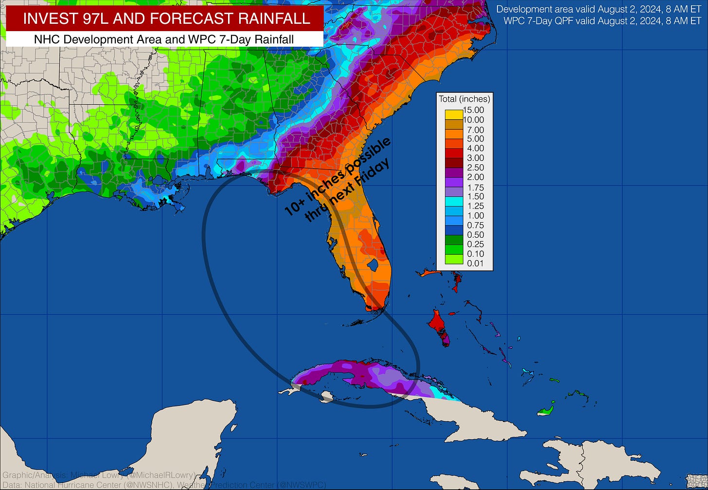
Heavy rainfall and inland flooding a growing concern into next week
Regardless of how much the system develops, the potential for heavy rainfall this weekend into early next week for parts of Florida and the southeast U.S. is a growing concern.
For those of us in southeast Florida and the Keys, any flood threat appears localized at this stage, with totals generally in the 2-to-4-inch range (with locally higher amounts), peaking tomorrow and lingering into early Sunday.
The bigger flood threat will be along the western peninsula, Big Bend, and into parts of north Florida later this weekend and early next week. Until the system gets closer in or better organized, however, expect the rainfall bullseye to change, but the general flavor of double-digit rainfall totals and the threat of significant flooding will persist for parts of the southeast, extending perhaps into the coastal Carolinas next week.
The eastern Gulf hotbed
As we discussed in yesterday’s newsletter, the eastern Gulf of Mexico is one of the last places we want to see a developing storm system in the coming days. Water temperatures are not only the warmest on record for the time of year in this area but are some of the warmest waters anywhere on the planet right now.

Over the past few days, buoys along the Gulf Coast of Florida near and north of Tampa have measured water temperatures as hot as 91 to 92 degrees Fahrenheit.


The record water temperatures in the eastern Gulf are not only a fuel source for would-be storms but can also supply ample low-level moisture to enhance the heavy rain threat.
Additionally, as we’ve covered extensively in newsletters this week, the eastern Gulf will be under very light wind from a sprawling area of high pressure aloft. This means little in the way of hostile wind shear to impede development.
The question is how long the system is able to spend over the eastern Gulf before moving inland. A quicker turn into Florida’s west coast would limit that development potential, but a broader turn farther up the coast would give more time for strengthening before affecting the coast.
Impacts expected soon
Rounds of blustery winds and tropical downpours will move into southeast Florida in earnest tomorrow and linger into Sunday. Though localized flooding is possible, we’re not expecting widespread flood issues or damaging winds.
Interests farther up the Florida peninsula and along Florida’s Gulf Coast, including the Big Bend into north Florida, should follow the changing forecasts closely. A more serious wind threat can’t be ruled out if the system forms farther west or takes a wider turn.
Regardless, heavy rainfall and the threat for significant flash flooding may accompany the system into parts of the southeast U.S. into next week.
Hurricane Hunters are scheduled to investigate the disturbance beginning this afternoon.


Damn, it looks like it will hit my side of Florida. Lovely...NOT! Was hoping to get through August without problem but oh well, that's life. Thank you for the heads up on the details Mr. Lowry. My county has issued a tropical storm watch but of course no details.
Excellent summary and reasoning!