Odds Increase for Tropical Formation this Weekend or Early Next Week
Developing system could enter the Gulf next week but a U.S. threat is unlikely
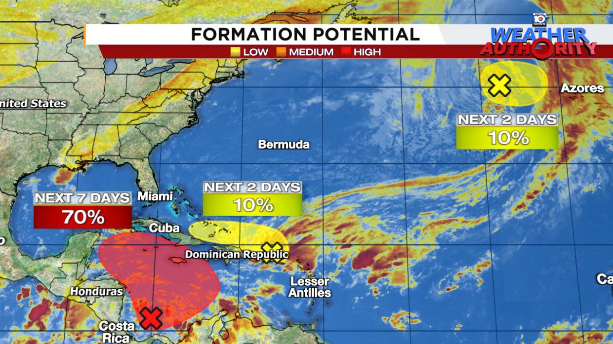
The next storm in the Atlantic is likely to spin up over the weekend or early next week out of the Central American Gyre or CAG, the semi-permanent, sprawling area of spin that straddles the land areas separating the eastern Pacific and the Caribbean Sea on the Atlantic side, the same feature responsible for so many of our devastating hurricanes in 2024 – including the likes of Milton and Helene.
Unlike those major hurricanes earlier in the season, this next system will be battling the antagonistic air of November – hurricane season’s final month – and will have an uphill climb as it enters the Gulf of Mexico deeper into next week. The biggest threat, at least through the middle part of next week, will be the potential for heavy rains to spread over land areas near and east of where the low-pressure area comes together, including places like Haiti, eastern Cuba, and Jamaica.
Familiar origins
As we’ve discussed in so many of our newsletters over the years, the Central American Gyre or CAG is a breeding ground for tropical systems, especially on the shoulders of the hurricane season, including October and November.

The broad center of the CAG today is over the southwestern Caribbean off the coast of Nicaragua and is forecast to rotate northward into the central Caribbean over the weekend where it will fuse with a broad area of low pressure left behind from a dying cold front to its north (the yellow area outlined to its north).
The combined areas of spin are what’s expected to trigger the development of a tropical depression or named storm moving into early next week. It’s still a question of how quickly development happens but it should be a gradual process that could stretch into Election Day.
The next name on the list is Patty.
Gulf bound next week
As we detailed in earlier newsletters, high pressure steering to the north will keep this one moving westward on a course south of Florida into the southern Gulf of Mexico for late next week.

The unusually strong high-pressure steering for November may even keep it on a track toward Mexico for next weekend, though it’s too soon to say for sure. Even if it bends northward into the central or northern Gulf deeper next week, it’ll get quickly dismantled by a blistering wall of wind shear tearing across the entirety of the northern and central Gulf of Mexico.

So while whatever comes of the system could bring impacts to parts of Mexico and Central America next week, it’s unlikely the U.S. will see any significant impacts given the hostile upper-wind configuration of early November.
Atlantic quiet elsewhere
The only other area worth mentioning today is a non-tropical area of low pressure that pinched off from a cold front over the far north Atlantic several hundred miles west of the Azores. While it could develop some subtropical characteristics over the next day or so, the only interest for us in the U.S. is whether is steals the next name on the list.
For now, NHC gives it a low chance of doing so.


Thank you for your measured information.
One gets tired of manufactured drama