Hurricane Debby Hits Florida's Big Bend, Catastrophic Flooding Likely this Week
Debby to slow to a crawl over or near the southeastern U.S. coast, bringing the threat for historic heavy rainfall across southeast Georgia and South Carolina through Saturday morning
After lashing the west coast of Florida all day Sunday with gusty winds, tropical downpours, and damaging storm surge, the eye of Hurricane Debby came ashore around daybreak Monday near Steinhatchee in Florida’s Big Bend, only 9 miles southeast of where Category 3 Hurricane Idalia came ashore just 341 days ago.
Though officially a Category 1 hurricane at landfall with sustained 80 mph winds, the hurricane brought Category 2 wind gusts to 98 mph Monday morning to nearby Horseshoe Beach as its center approached the coast. Moderate coastal flooding was ongoing at Cedar Key about 50 miles southeast of Debby’s center, where a 6-foot storm surge coincided with the day’s lowest high tide.
To the west over the state capital of Tallahassee, winds gusted to 44 mph but Debby, like Idalia last August, spared the panhandle’s largest population center the brunt of its damaging weather.
Debby largely tracked east of the official forecast during the day yesterday, favoring the right side of the forecast cone from yesterday morning.

So far, Perry, Florida, to Debby’s west has picked up over half a foot of rain since late Sunday night and Debby’s blistering outer rainbands brought a foot or more of rain to portions of the western peninsula during the day Sunday, including areas near Lakeland, Pinellas Park, and Sarasota-Bradenton.
Farther south, Debby’s strong onshore flow contributed to a 2-to-4-foot storm surge Sunday afternoon that flooded some low-lying coastal locations in southwest Florida, including parts of downtown Fort Myers and Fort Myers Beach.
The worst of Debby is yet to come
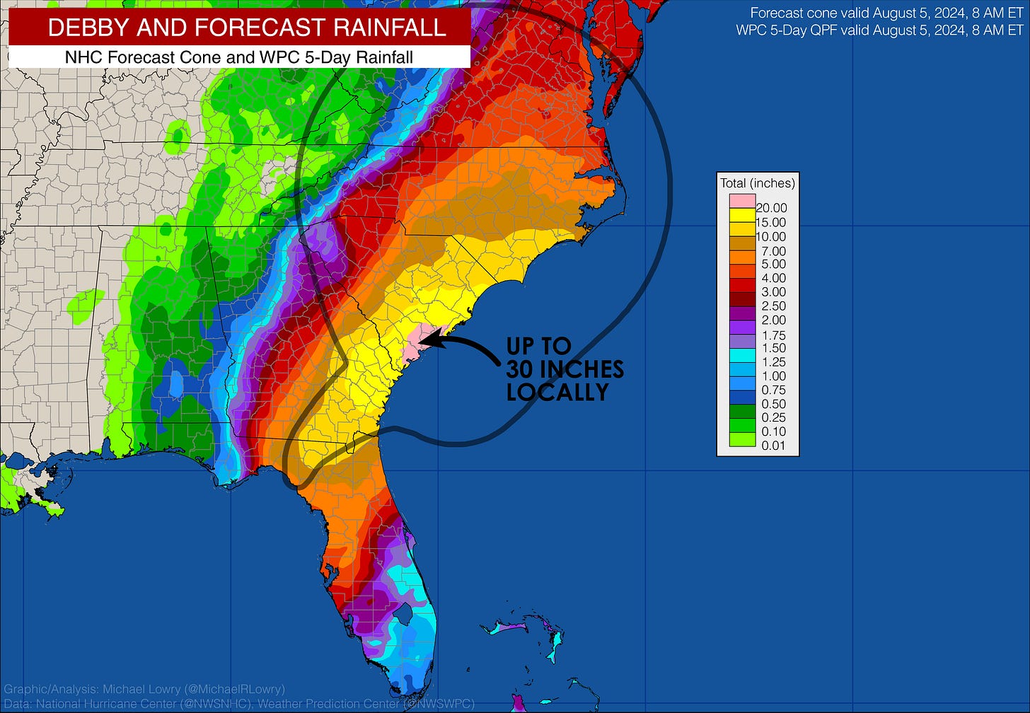
The biggest concern as Debby moves inland is the major slowdown anticipated by tomorrow, as steering currents collapse, leaving the storm to rain itself out over parts of north Florida, southeast Georgia, and the coastal plain of South Carolina for the remainder of the week.
This is expected to bring up to 30 inches of rainfall to some places – historically high totals that could break state rainfall records in South Carolina and Georgia – and will likely contribute to widespread and potentially catastrophic flooding this week.
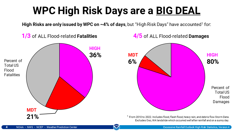
The Weather Prediction Center has issued a high risk for excessive rainfall from tomorrow through Thursday morning stretching from north Florida into the coastal Carolinas, indicating the likelihood of severe and widespread flooding. While high risk rainfall outlooks are only issued for about 4% of days, they account for 80% of flood-related damages and more than a third of all flood-related fatalities.
What we’re following behind Debby
Beryl and Debby may only be the warm-up acts for the busy stretch of hurricane season ahead. As Colorado State University hurricane expert Dr. Phil Klotzbach noted, only 8 other hurricane seasons have observed two U.S. landfalling hurricanes this early in the season: 2020, 2005, 1959, 1936, 1934, 1916, 1909, and 1886, with most of these seasons especially destructive and impactful for the United States.
This week, we’re following a strong tropical disturbance now entering the eastern Caribbean. The system will be moving quickly through the Caribbean over the next few days, but models indicate possible development once it slows down later this week and into the weekend over the western Caribbean and southern Gulf of Mexico.
For now at least steering patterns favor a trajectory to the south of South Florida and toward the western Gulf, but we’ll continue to monitor its progress. We still have some time to watch this one.


So far, this new disturbance looks to be more or less of a Mexican problem and spare the U.S. if the track is correct.