Hurricane and Storm Surge Watches Issued for Florida's Gulf Coast as Major Hurricane Threat Looms
Hurricane Watches now in effect from near Apalachicola to south of Sarasota, including Tallahassee and coastal Tampa and Pinellas

Hurricane and storm surge watches were hoisted early Tuesday for a wide stretch of Florida’s Gulf Coast ahead of what’s forecast to be a major hurricane strike come late Thursday or early Friday.
Storm surge watches stretch from Apalachicola and St. George Island in Florida’s eastern panhandle southward to the tail of the state’s western peninsula, including cities like Naples, Fort Myers, Port Charlotte, Sarasota, Tampa, and Cedar Key.
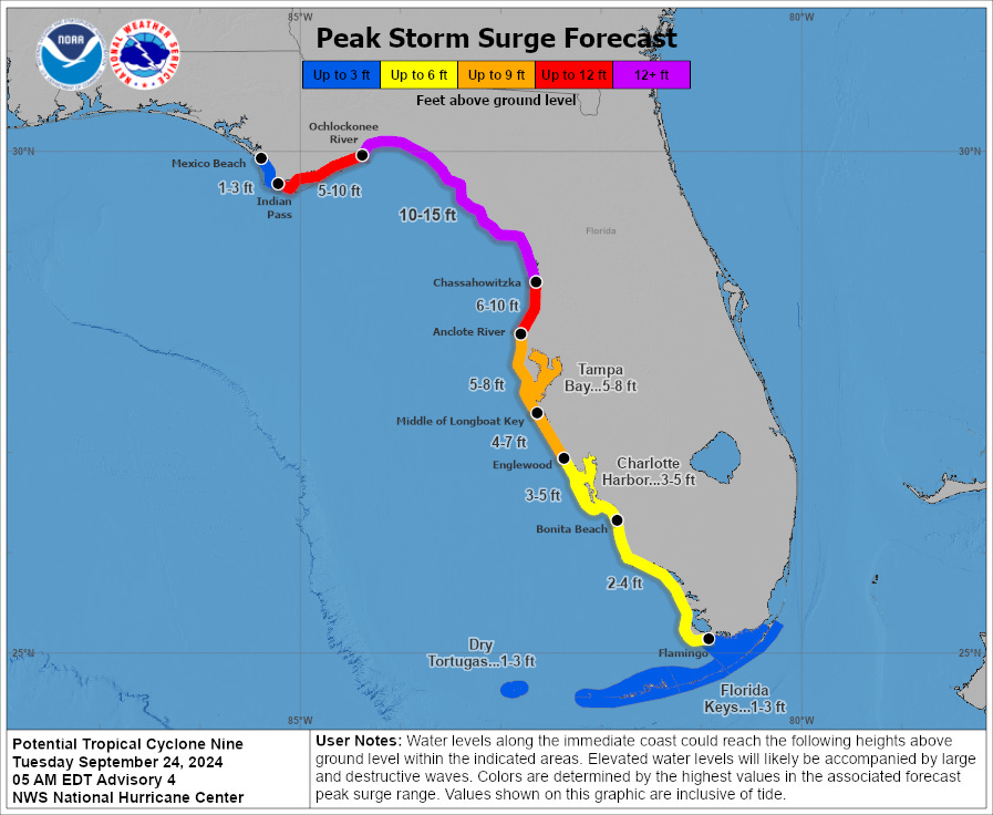
Up to 15 feet of potentially catastrophic and life-threatening coastal storm surge is forecast, centered from near Alligator Point and St. Marks down to just south of Crystal River and Homosassa in Florida’s sweeping Big Bend, including Cedar Key and Steinhatchee, locations recently affected by Hurricanes Idalia and Debby.
A hurricane watch means hurricane conditions (winds of 74 mph or stronger) are possible, and hurricane watches are typically issued 48 hours before the expected onset of tropical storm (39 mph or higher) winds to give adequate time for preparation.
A storm surge watch means life-threatening conditions are possible from coastal inundation within about 48 hours.
No tropical watches or warnings have been issued for Miami-Dade or Broward Counties but a tropical storm watch is in place for the lower Florida Keys from west of the Seven Mile Bridge, including Big Pine Key, Key West, and the Dry Tortugas. Tropical storm conditions (39+ mph winds) will affect the lower Keys beginning on Wednesday.
A tropical storm watch is also in place across central Florida, including Orlando, as the looming hurricane’s large wind field stretches into inland areas of the Sunshine State.
Shear holding down organization…for now
As of early Tuesday, the low-pressure area over the northwestern Caribbean – designated Potential Tropical Cyclone Nine – remained disorganized and hadn’t yet gained enough organization to be upgraded to Tropical Storm Helene.
The short-term obstacle for development has been wind shear – strong winds at upper-levels “tilting” the fledgling system and keeping thunderstorm activity displaced to the east of the low-pressure center. Some of this added wind shear has been courtesy of a rapidly strengthening Hurricane John in the eastern Pacific, a hurricane that overachieved most forecasts as it came ashore as a major hurricane shortly before midnight only about 40 miles east of Acapulco, Mexico.
The shear is forecast by models to quickly relax today, with an orientation of upper-level winds that should allow thunderstorm activity to build westward and over the circulation center, especially by late today and early Wednesday as soon-to-be Helene tracks into the Yucatán Channel between Mexico and Cuba.
We may already be seeing a slackening of the shear this morning as satellite shows billowing storminess slowly edging westward. Additionally, the most recent pass from NOAA hurricane hunters shows a more aligned vortex – with the mid-level and low-level centers becoming increasingly stacked, a sign the system is on the verge of becoming Tropical Storm Helene.

Forecast track largely unchanged from yesterday
Forecast models have been largely consistent on a track toward the northeastern Gulf Coast, with the greatest threat for significant impacts between Apalachicola and Tampa, centered on Florida’s Big Bend and including the state capital in Tallahassee.

Landfall still appears most likely from late Thursday into early Friday.

The big question that remains is how organized Helene becomes over the Gulf of Mexico tomorrow and Thursday. As we’ve covered in previous newsletters, the storm will be moving across a particularly warm and deep patch of Gulf water associated with the loop current. Additionally, the atmosphere and upper-level wind configuration appear largely conducive to pronounced strengthening so the ceiling is high.
Intensity models are in good agreement with a major (Category 3 or stronger) hurricane nearing the coast on Thursday as the National Hurricane Center forecasts, but the range of possibilities is wide, from a Category 1 hurricane to something much stronger. Perhaps most concerning is the insistence of the high-resolution hurricane models – models such as HAFS, HWRF, and HMON that have historically performed well with intensity forecasts – depicting the higher-end scenarios.

Regardless, the general theme is the environment ahead remains ripe for strengthening. Even if lower-end scenarios come to pass, future Helen’s widening wind field is going to prove extremely problematic for Florida’s west coast. Those far removed from the center could see serious impacts, especially along the coast in the way of significant and perhaps catastrophic storm-surge-related flooding.
Water is responsible for 90% of historical hurricane deaths, so remember to not focus on the exact track.
Impacts well inland across the southeast
The odds of a strengthening hurricane accelerating as it comes ashore could bring considerable impacts deep into the southeastern U.S. for the latter part of the week.
In addition to the threat for widespread power outages from strong inland winds, heavy rainfall will pose a threat of numerous flash floods beginning late Thursday and on Friday, stretching into north Georgia and Alabama through parts of the Tennessee Valley and western Carolinas.
The heavy rain threat should subside quickly over the weekend as Helene merges with a front.
High development odds in the eastern Atlantic
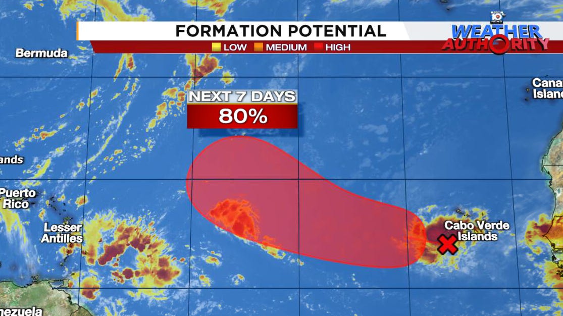
A system in the eastern Atlantic near the Cabo Verde Islands off African has a high chance of development for later this week over the eastern Atlantic.
The good news is models show this one cleanly turning out to sea by early next week without posing any threats to land.


That Cape Verde storm looks to go toward Bermuda. It COULD become a serious threat THERE in coming days.
Well, it looks like it will get a bit windy here tomorrow as Helene passes by...so long as she doesn't decide to do a nasty trick and turn right. I am sorry to see the Big Bend area will get slammed again, that is hell for those poor people and animals.