Drought-Busting Tropical Rains on the Way to South Florida
Big rains from Tuesday into the weekend will bring prolonged flash flood threat, but no organized tropical development is expected
As we previewed in last Thursday’s newsletter, the pattern is about to get noticeably stormier as an influx of rich tropical air overspreads South Florida, spurring a multi-day heavy rainfall event starting in earnest tomorrow into Wednesday.
Though the unsettled weather will have tropical origins, a jet stream dip and stalled front over north Florida will be the primary focus for rounds of heavy rains to the south. The strong nearby jet stream will stifle any organized tropical development but will serve to aggravate the potential flood threat.
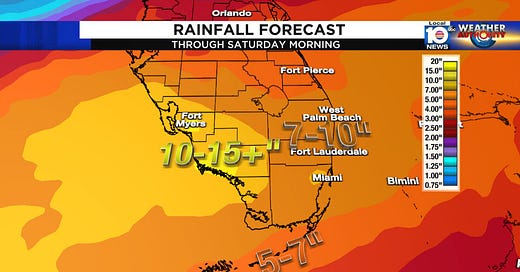
The National Weather Service is forecasting upwards of 10 to 15 inches of rainfall locally through Saturday south of the I-4 corridor, and most of South Florida is at risk of scattered flash flooding, especially by mid to late week.
As we discussed last week, much of South Florida is in moderate to severe drought so the rainfall isn’t all unwelcome news.
We’ll need to see how the rainfall plays out today and tomorrow. Since the soil is starting off dry, higher totals earlier in the week would naturally increase the flood threat later in the week. Localized flooding of urban and low-lying areas will be a concern regardless, and the Weather Prediction Center is advertising a slight risk for excessive rainfall and flooding from Wednesday into the weekend.

Be sure to follow Betty and your Local 10 Weather Authority team all week for the latest updates.
Keeping an eye to the southwestern Gulf starting this weekend
As the heavy rain and flood threat eases up across South Florida late in the upcoming weekend, we’ll turn our attention to the southwestern Gulf of Mexico as a broad region of low pressure takes shape around the Yucatán Peninsula. We previewed this area in last Monday’s newsletter as our first window for tropical development.
We’ll have more to say on this later in the week, but with high pressure building back in over the southeast U.S. and Florida next week, anything tropical that comes of it would more than likely get shunted away from us here in South Florida. For now, the models are only lukewarm on possible development early next week but it’s a stronger signal than we’ve seen so far this season, so we’ll check back.


Thank you for details explaining how this system will or will not come together but to expect massive rains
Well we need the rain badly so I guess we shouldn't complain at getting a lot of it all at once. Ian didn't cause us much in the way of flooding so this shouldn't be too awful bad for my area but some will catch hell in the lower areas.