


Critical Hurricane Forecast Tool Abruptly Terminated
U.S. Department of Defense announced Tuesday it would no longer process and deliver data essential to most hurricane forecasts


On Tuesday, the U.S. Department of Defense announced it would immediately stop ingesting, processing, and transmitting data essential to most hurricane forecasts.
The announcement was formalized on Wednesday when NOAA distributed a service change notice to all users, including the National Hurricane Center, that by next Monday, June 30th, they would no longer receive real-time microwave data collected aboard three weather satellites jointly run by NOAA and the U.S. Department of Defense.
The permanent discontinuation of data from the Special Sensor Microwave Imager Sounder (SSMIS) will severely impede and degrade hurricane forecasts for this season and beyond, affecting tens of millions of Americans who live along its hurricane-prone shorelines.
The news on Wednesday sent users across the weather and climate community – including those monitoring changes to sea ice extent in the polar regions – scrambling to understand the rationale behind the abrupt termination. Though not immediately clear why the real-time data was suddenly discontinued, the decision appears to have stemmed from Department of Defense security concerns.
Officials at the National Hurricane Center were also caught off guard by the announcement and are preparing their team for the loss of critical forecast data for the rest of the hurricane season.
Increased risk of a “sunrise surprise”
Since hurricanes form and strengthen over the open water where direct observations are scarce or nonexistent, forecasters rely largely on data remotely gathered from satellites. While hurricane hunting airplanes help to close that gap, they’re only available for about 1 in every 3 hurricane forecasts in the Atlantic and virtually none – except for a handful of stronger storm exceptions – in the Pacific.
Traditional weather satellites are helpful, but they don’t allow forecasters to peer beneath the clouds to understand important structural changes that can tip them off to episodes of rapid intensification. At night especially, geosynchronous satellites most familiar to the general public can fail forecasters, often missing important details only seen by visible satellite or critical microwave pictures from polar-orbiting satellites that provide MRI-like scans to forecasters every few hours.
The Defense Meteorological Satellite Program and its constellation of three weather satellites provide roughly half of all microwave satellite scans to forecasters. Those go dark beginning next Monday.
“Their loss is a big deal,” says retired National Hurricane Center branch chief James Franklin, who oversaw all NHC hurricane forecasters until his retirement in 2017. “Without this imagery, there will be increased risk of a ‘sunrise surprise,’ the realization from first-light images that a system had become much better organized overnight, but it wasn’t recognized because structural details are so hard to discern from [infrared satellite].”
Microwave data are also used to help “fix” or position the center of storms, a task not always easily or accurately accomplished using visible or enhanced satellite pictures. As the butterfly effect demonstrates, small errors in the initial positioning of a storm can lead to outsized forecast errors in four or five days. “For weaker systems, [it’s] increased initial position error (in the tens of miles) that will cascade into poorer track forecasts,” warns Franklin.
Microwave data such as those from the DoD Special Sensor Microwave Imager Sounder are essential to hurricane forecasts, not a nice-to-have. They’re used in a variety of critical applications, including estimating hurricane intensity through AI-driven neural networks like the Deep Multispectral INtensity of TCs estimator or DMINT. In the absence of hurricane hunters, DMINT has been shown to be one of the most crucial tools in a hurricane forecaster’s arsenal for estimating storm intensity, largely because of the microwave data it utilizes.
Though other microwave data will still be available to forecasters, the DoD weather satellites comprise half of all microwave instruments, which means data availability will be sliced in half, greatly increasing the odds of missing rapid intensification episodes, underestimating intensity, or misplacing the storm and degrading forecast accuracy.
While the Department of Defense did successfully launched another weather satellite known as the Weather System Follow-on Microwave (WSF-M) in April 2024, that data isn’t currently available to forecasters and it’s not clear if or when data access will be permitted.
NOAA responds (June 27th Update)
I reached out to both NOAA and Department of Defense for comment on Thursday and received the following reply from a NOAA spokesperson late Friday (as of this writing, no response from the Department of Defense):
“The DMSP is a single dataset in a robust suite of hurricane forecasting and modeling tools in the NWS portfolio. The current models continue to include data from:
GOES and other geostationary Earth-observing satellites
Polar-orbiting satellites, including Joint Polar Satellite System (JPSS) and EUMETSAT MetOp
Hurricane Hunter aircraft reconnaissance missions and other aircraft-based observations
Observations on the ground and from buoys
Radiosondes and supplemental upper air soundings
Ground-based weather radar sites in the U.S. and neighboring countries
In particular, the Advanced Technology Microwave Sounder (ATMS), currently flying on NOAA’s JPSS, provides the richest, most accurate satellite weather observations available. NOAA’s data sources are fully capable of providing a complete suite of cutting-edge data and models that ensure the gold-standard weather forecasting the American people deserve.
For more information regarding DSMP, please reach out to the Department of Defense.”
I’ve highlighted one standout line from NOAA’s reply that suggests using the Advanced Technology Microwave Sounder or ATMS aboard the three surviving NOAA satellites, the other half available to forecasters not operated by the Department of Defense, as an SSMIS replacement.
The ATMS sounder that remains is far inferior to hurricane forecasters than the SSMIS instrument the Department of Defense is discontinuing. Unlike the SSMIS which scans at a continuous resolution, the quality of the ATMS degrades considerably on its edges, rendering the sounder useless for most operational hurricane forecasts. The example below shows the difference between the scans from both instruments for Hurricane Erick last Wednesday, June 18th.
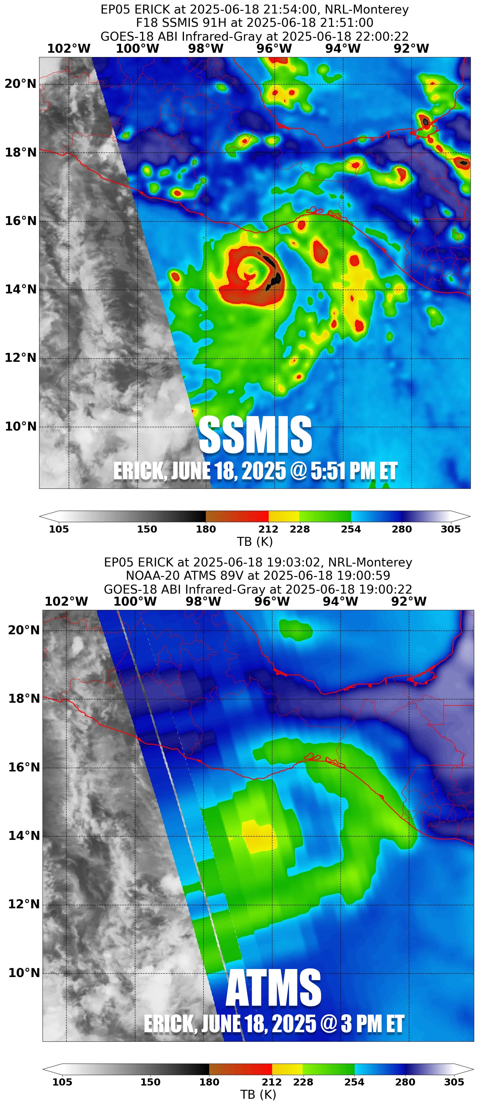
The NOAA ATMS pass needs to land a perfect bullseye on a hurricane to be of any real-time use to forecasters, a rare feat. Even when it does, the superb resolution of the SSMIS is typically preferred. ATMS is not a replacement for SSMIS, which is the reason why forecasters and hurricane scientists are sounding the alarm.
Secondly, the 6-7 microwave satellites available now only give us MRI-like snapshots of active storms every few hours. Cutting those satellites in half means increasing the gap in data availability from every few hours to as much as every 12 hours. And as discussed in the previous paragraph, the remaining data is far inferior and in most instances useless to forecasters and models in real-time.
This means a much a higher risk of missing episodes of rapid intensification in the absence of hurricane hunters (only available for about 1 in every 3 forecasts) and less warning time for residents when a hurricane is rapidly forming or strengthening near the coast, giving those in harm’s way less time (or even no time) to prepare or evacuate.
Moratorium granted through July (June 30th Update)
On Monday, June 30th – the original date all three defense meteorological satellites were to cease transmitting microwave data – NOAA issued an urgent update pausing the termination of data through the end of July. Despite the “significant cybersecurity risk” to Navy supercomputers cited for the abrupt termination of data critical to hurricane forecasters and other scientists, a request from NASA, also blindsided by the sudden announcement, compelled defense officials to delay the decommission through the end of July.
Despite operable satellites, the Department of Defense is still planning to end the transmission of microwave data before hurricane season peaks in August, September, and October, as hurricanes hit their stride and episodes of rapid intensification – a dangerous and potentially life-threatening phenomenon the constellation of satellites guards against – are most common.

The latest update from NOAA raises more questions than it answers. If the termination is due to a "significant cybersecurity risk", why grant a month reprieve? If the data can continue to flow harmlessly through July, why the initial rush to immediately shut it off?
As far as we know, the defense satellites work, will continue to operate through the hurricane season, and may operate through the 2026 hurricane season. Why not do everything we can to keep the data flowing to scientists who use it to forecast some of the deadliest storms on earth?
Ending June with no Atlantic concerns

Forecast models continue to show a quiet Atlantic through the waning days of June, with no development expected over at least the next week or so.