


Troubling Forecast Ahead for Florida and the U.S. Gulf Coast
As Category 4 Fiona turns northward toward Bermuda, U.S. interests eye Invest 98L approaching the Caribbean

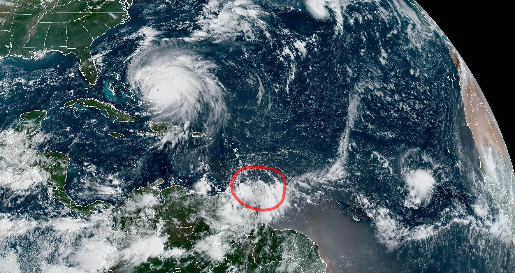
As Hurricane Fiona pulls away from the Turks and Caicos as a powerful Category 4 hurricane and newly formed Tropical Storm Gaston nears hurricane status over the open waters of the north Atlantic, a strong tropical wave moving toward the Caribbean will command our attention in Florida as it takes shape in the coming days.
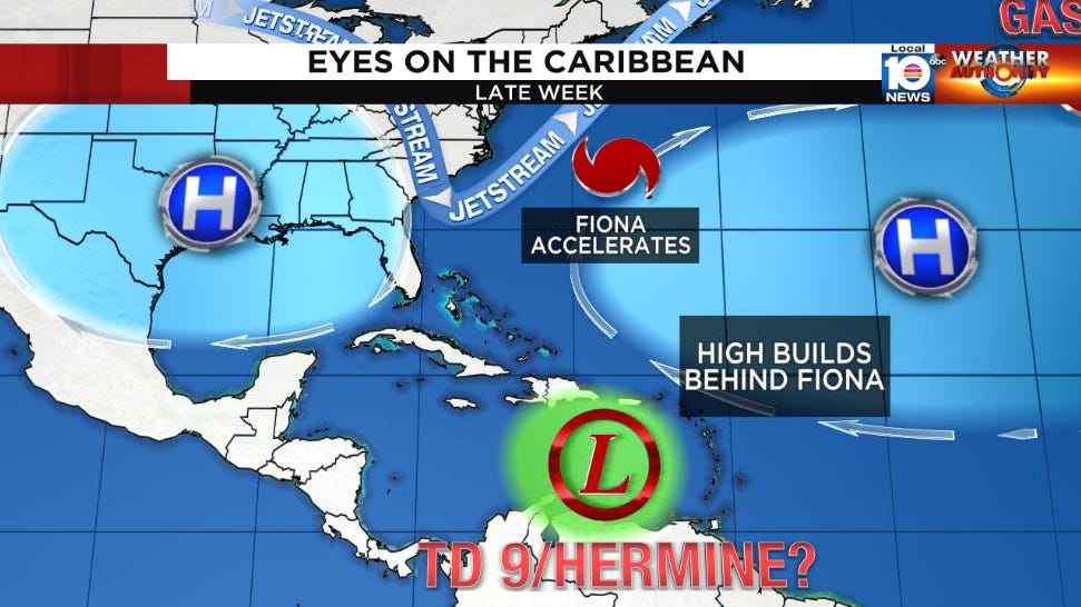
The disturbance – designated Invest 98L by the National Hurricane Center – may take a little time to cook, in part due to Hurricane Fiona’s expansive upper-level exhaust impinging on its percolating storminess. This northerly wind shear is forecast to persist until late week into the weekend, as Fiona accelerates north and west of Bermuda. By late weekend, the upper-level pattern will shift into a configuration that can best be described as pristine for storm growth potential, with a large upper-level region of high pressure dominating the central Caribbean, helping to ventilate 98L’s increasingly concentrated storminess.

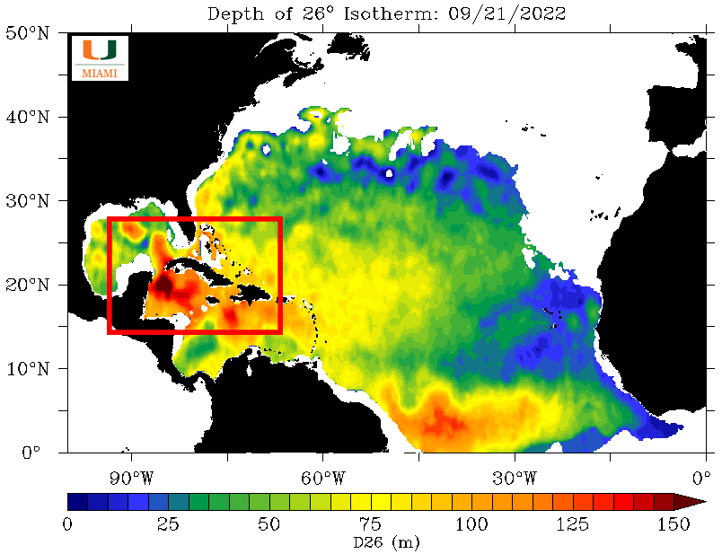
This will all be happening in a part of the Atlantic where water temperatures are near their warmest of the season, not just at the surface, but a deep reservoir of 80-plus degree water extending down 400 to 500 feet in some spots of the western Caribbean and Gulf of Mexico.
It’s a volatile mix for an organizing storm that would favor significant strengthening by early next week.
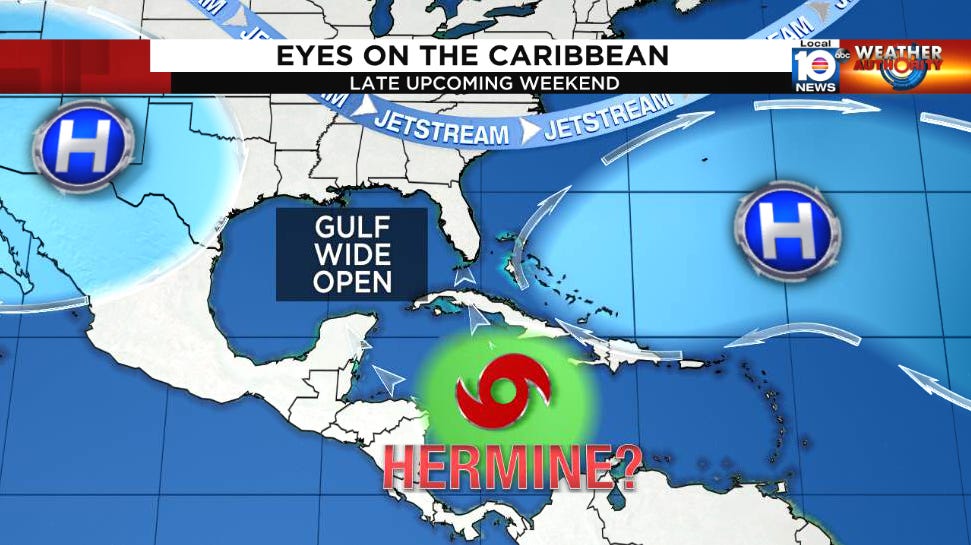
Regardless of where 98L ultimately forms, high pressure steering building back behind Fiona will guide it toward the western Caribbean for the start of next week, with a plunge of fall air into the eastern U.S. signaling a dip in the jet stream that’ll allow the looming storm to turn northward toward the Gulf.
As you might expect from previous newsletters, it’s too soon to give specifics, as small changes in just the next few days alone, such as where 98L’s center forms or how quickly it moves, can dramatically affect where it ends up in 7 to 10 days. For South Florida, this is a watch and wait, but while we gather up more details in the days ahead, take the time to button up plans should we see a threat next week. Hurricane hunters are tentatively scheduled to investigate 98L beginning this evening should development trends warrant.
For our storm-weary neighbors to the south in Puerto Rico and the Dominican Republic, the disturbance should stay well to your south, but moisture along its northern edge may enhance rainfall this weekend across the islands as it passes.
Hurricane Fiona, now a Category 4 hurricane and the strongest storm of the hurricane season so far, is pulling away from the Turks and Caicos after battering the small archipelago near the southeastern Bahamas for most of yesterday. The hurricane may strengthen a little further today as it accelerates northward, where it will pass west of Bermuda by early Friday. Because it will have a growing wind field as it moves toward Bermuda, a tropical storm warning and hurricane watch are in effect for the British island territory.

It's worth noting that as Fiona morphs into a large extratropical storm this weekend over eastern Canada, it may threaten September records for low sea-level pressure over the Canadian Maritimes.


Elsewhere in the Atlantic, Invest 97L yesterday strengthened into Tropical Storm Gaston over the middle of the open north Atlantic. While Gaston poses no threat to land, it quickly outperformed forecast expectations and was nearing hurricane strength by Wednesday morning. The Hurricane Center is also monitoring two other tropical waves in the eastern Atlantic this week, but neither is a concern for us on the other side of the pond.

Thank you. I learned my first year here in Punta Gorda after seeing the crowds when Erika was predicted to come this way. Thankfully she fizzled out but I decided after that to stay prepared all through the season. I keep in meds, batteries, water bottles (30 one gallon bottles empty until near a storm) battery operated lights, several power chargers, nonperishable food, etc and the gas tank is kept filled well ahead of any storm that may come this way. I have several plans if need to evacuate. I will never be caught like that again. There are still two blocks downtown with no buildings on them left from Charley and I have seen the vids of it. Nope, not playing silly games with those things.
Now that Gaston has formed, the next name to be used will be Hermine, if it indeed forms. If this forms, it likely is going close to the Panhandle. It would look like Tampa to Panama City may need to pay attention to this one. So should Cedar Key. That would only be preliminary. Time will tell. If the European is correct, could this go EAST of the Appilichians and give some steady rain to New York State? Again, time will tell; that's days away, but if anyone has any travel plans for around October1st, that's something. to keep in mind. If it goes WEST of the Appilachians, not much rain to be expected, if at all, for new York State. I will tend to go with the WEST of the Appilichians for now.