Invest 91L Likely to Develop, Head Toward the Western Atlantic
Two NOAA Hurricane Hunter planes scheduled to investigate the system today
On a map cluttered with would-be tropical systems this week, an area of low pressure traversing the central Atlantic – designated Invest 91L – will be the one to watch.
Among other disturbances being monitored this week are Invest 92L – a small, but well-defined swirl of low-level clouds spinning adrift over the open waters of the north-central Atlantic well east of Bermuda – as well as a system expected to emerge off the coast of Africa later today. Invest 92L has been a whirling dervish in recent days, but the puffs of occasional thunderstorms have been no match for very hostile upper-level winds. Meanwhile, the system exiting Africa today may bring weather through the Cabo Verde Islands by mid-week but is no concern for us at the moment.

The area highlighted in the western Caribbean north of Honduras is largely unrelated to the tropical wave we discussed yesterday moving south of Jamaica, but rather a new area of low pressure that may form later this week. Models aren’t keen on much happening here, and even the American GFS model, which has a history of overcooked forecasts in this part of the world, has backed off earlier bullish forecasts. Regardless of development, this is no concern for South Florida.
As for the main event – Invest 91L organizing in the central tropical Atlantic – despite a morning satellite pass estimating nearby winds near tropical storm strength, the area of spin is broad and elongated, and we’ve yet to see organized and persistent storminess, a prerequisite for tropical development.

A high-altitude NOAA hurricane hunter jet dropping instrument packages in the environment around the disturbance yesterday found an adverse atmosphere laden with mid-level dry air and modest wind shear. A moisture-starved Atlantic may continue to be an impediment for 91L, but gradual development is expected nonetheless.
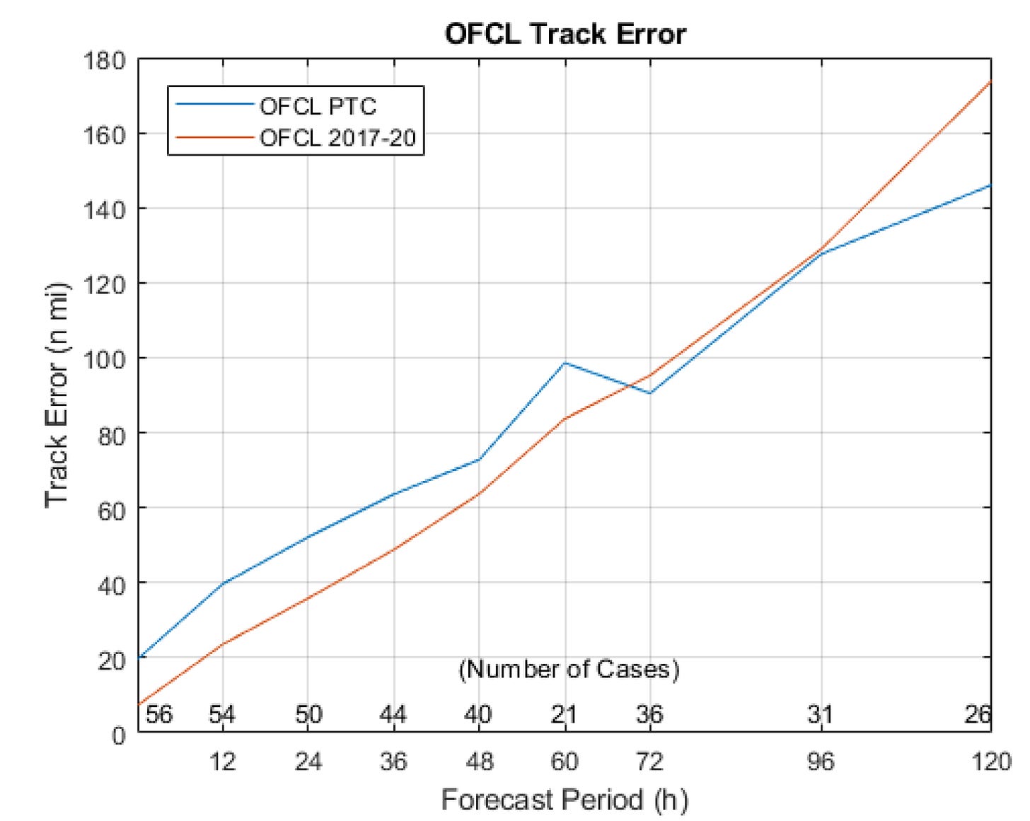
It's worth reiterating that until a well-defined center forms, we can expect higher than average uncertainty in the forecast track of 91L. In a recent comparison study from 2017 to 2020, forecasters at the National Hurricane Center found higher track errors with forecasts of Potential Tropical Cyclones – developing tropical systems that haven’t fully formed – largely due to uncertainty in center position and center reformations common during nascent stages. These small initial errors can be greatly exaggerated down the line, so even for the short-term, where the steering pattern is clearer, expect above-average deviations in where the system ultimately ends up.

The disturbance has slowed down today as a large cut-off upper low spinning to its north has weakened subtropical high-pressure steering. This will also allow 91L to gain a little latitude over the coming days. As this upper-low weakens and departs by mid-week, however, high-pressure will rebuild above, directing 91L or Tropical Depression Four/Danielle into the western Atlantic by the end of the workweek. Guidance largely keeps the system north of Puerto Rico and the U.S. Virgin Islands this weekend, but interests here should continue to closely monitor the evolving forecasts.
The big question for South Florida, of course, is what happens into Labor Day? We’ll need a system to break apart the high-pressure steering to give 91L, or what comes of it, an escape route. Extended range models do show a dip in the jet stream over southeastern Canada and into the northeastern U.S. by late next weekend that could open the escape hatch, but it’s going to depend on factors that are unknowable this far out. As we previously discussed, slight variations in timing, intensity, and position can make all the difference down the line, so we’ll just need to stay patient this week. Interests in the southeastern Bahamas should continue to follow the forecasts closely.
The good news for now is we have plenty of time to follow and this week 91L will face an uphill battle to significant organization. Another high-level hurricane hunter mission – a Gulfstream IV jet – is scheduled for this morning to gather information about the environment around 91L. In addition, NOAA will send out a second hurricane hunter research airplane this afternoon to investigate what’s going on inside the system, including a look at the low-level wind field. The added data should help us begin to piece together a fuller picture and better narrow down the possibilities. Stay tuned.


Down the road, what will the weather systems do, as for any impact on the next launch attempt for Artemis 1 on Friday?