Tropical Depression Nine Forms, Florida and Eastern Gulf Face a Serious Hurricane Threat Next Week
South Florida should hurry hurricane preparations to completion today and this weekend
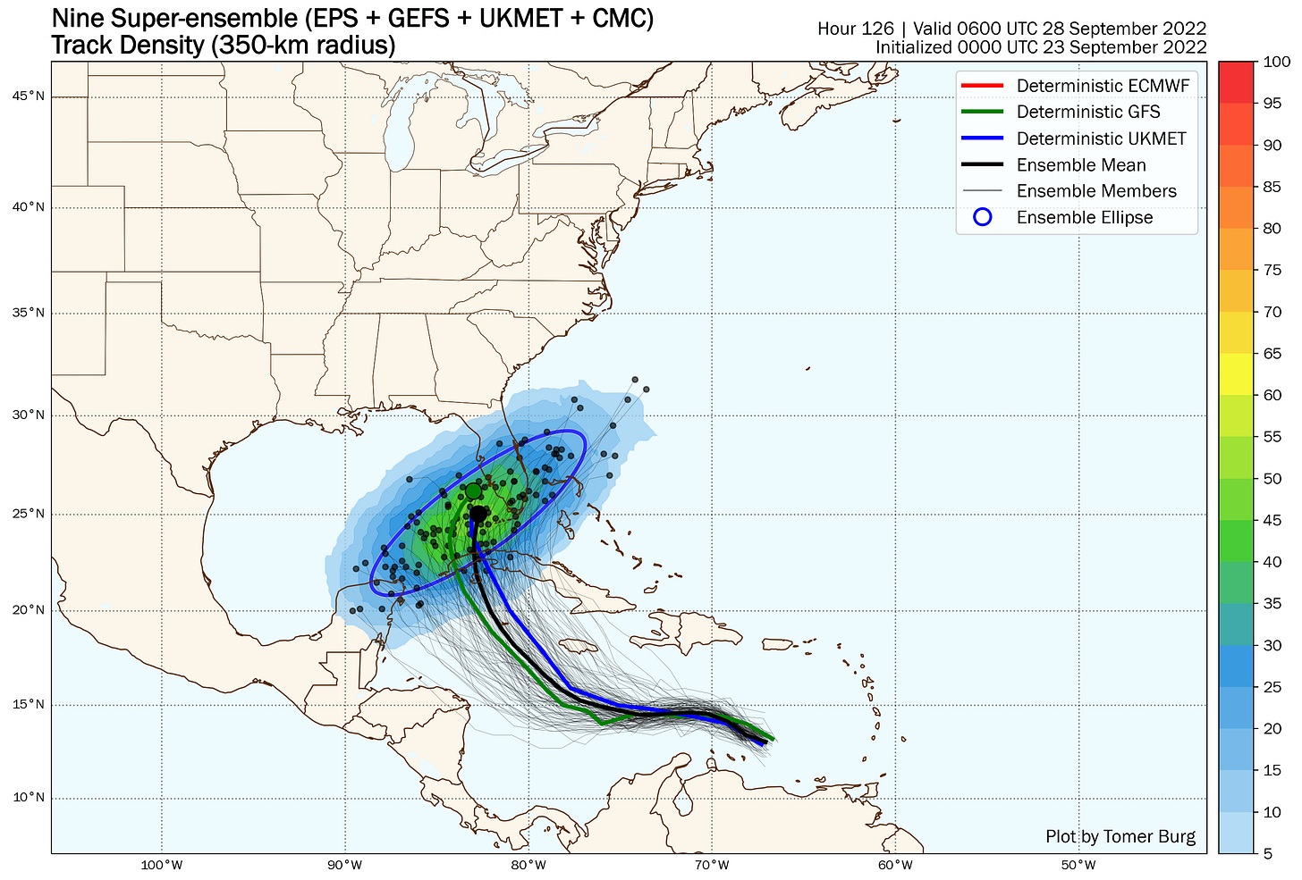
Tropical Depression Nine formed north of the ABC Islands in the eastern Caribbean this morning and the 5-day forecast cone includes the entire Florida peninsula and Florida Keys, where a strengthening hurricane is forecast to threaten by early next week. While the possible U.S. strike zone is wide –from the northern Gulf to the Florida Keys – tropical storm winds could begin as early as Tuesday in Florida, so South Floridians should complete hurricane preparations today and this weekend.
Thunderstorm activity, which increased and persisted overnight, remains well displaced to Tropical Depression Nine’s west and south due to strong upper-level winds from Hurricane Fiona’s outflow to the north and an upper-level area of low-pressure northeast of the Caribbean.

The shear limitation is expected to relax over the weekend as the Depression moves westward, which will allow for strengthening. All indications are by Sunday or Monday, we’ll have a strengthening hurricane in the western Caribbean.
The steering forecast beyond this weekend is tricky. We know the storm will turn north in response to the pull of a strong jet stream dip that’ll be ushering a cold front through the southeastern U.S. Since we’re still in the early stages of development, however, we don’t yet know exactly where the storm’s convection will pull together. Like football, hurricanes are a game of inches, especially when they’re turning, so the placement of the center by Sunday will have a big influence on how quickly and sharply it turns. A consolidation of convection farther south and west favors a more gradual turn into the eastern Gulf, where convection coming together farther north and east would favor a sharper turn toward South Florida.

By late Monday into Tuesday, the growing storm is forecast to move over western Cuba, which could act as a temporary speed hump. That said, it won’t be enough to deter a potentially major (Category 3) hurricane threat to the U.S. for next week.
Today, tomorrow, and Sunday, be sure to finalize your family preparedness plans. Gather important documents, be ready to install shutters if necessary, check with your physician’s office today for important prescription refills, and know if you live in a storm surge evacuation zone. For Miami-Dade residents, you can check your zone here, for Monroe County you can find your evacuation zone map here, and Broward County evacuation zones can be found here.
In general, evacuations in South Florida, if required, take place within a day or two of the expected onset of tropical storm winds (winds greater than 38 mph). Since tropical storm conditions could begin as early as Tuesday if the storm turns our way, evacuations may be required as early as this weekend for a significant storm threat. Always listen to your local emergency management officials for evacuation decision-making, and remember: if you’re asked to evacuate, do so immediately. In most cases you only need to go far enough inland to a safe place outside the storm surge evacuation zone.
A South Florida strike isn’t locked in, but with the threat of a significant hurricane increasing and a compressed timeline ahead, be ready to act sooner rather than later. Download our 2022 Local 10 Hurricane Survival Guide to your mobile device for step-by-step instructions and storm checklists, along with the latest hurricane evacuation zones and shelter information. Most importantly, check back with WPLG Local 10 for the latest updates. I’ll be on air and online along with South Florida’s largest team of meteorologists through the weekend and into the busy week ahead.


OK, have you read this, Laura? It is a tropical depression. This latest track can still change. It still hasn't even formed yet into a storm. It LOOKS like it COULD go toward Tampa as a Cat 3, IF this does form and goes your direction. There is no immediate danger now, but you may want to think about possible preps on the weekend, just in case. Stay tuned to WPLG for the latest updates, and this site.
Generally so, but much of the forecasting you see just for ordinary weather, is largely model-driven today not like the olden days of sleight-of-hand weather forecasting back in my day in the '60s and '70s. Today's hurricane forecasting, that's also pretty much model driven; they DO have to adjust these model tracks and especially intensity, and intensity forecasts often are not that great compared to track forecasts. How do you know if a forecast several days in advance is gonna be the correct solution? The key is consistency. If a model or consensus of them continue to say the same thing for several days in a row, that is your clue that, in the case of storms, you know this is serious. It's a heads-up to be prepared in case the forecast storm DOES indeed come to fruition.