Quiet Week Ahead in the Atlantic Behind Ernesto
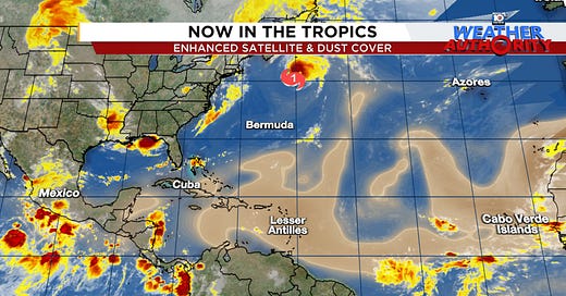
Dust-laden disturbances will be a short-term barrier to development this week, but don't expect a long recess
The large 100-mile-wide eye of Category 2 Hurricane Ernesto enveloped Bermuda around daybreak Saturday, bringing wind gusts as high 109 mph to the archipelago and knocking out power to 75% of the island at its height.

A 23-foot long Saildrone uncrewed surface vehicle – resembling an oversized surfboard replete with ocean instruments – which intercepted Ernesto last week measured significant wave heights (the average height of the highest 33% of all waves) as high as 36 feet shortly before 4 PM ET Friday with gusts to 94 mph while in Ernesto’s northwestern eyewall about 120 miles south of Bermuda.
Ernesto’s large circulation brought a long duration of gusty tropical storm winds above 39 mph to Bermuda beginning early Friday and lasting into the predawn hours Sunday. Bermuda famously has one of the best building code systems in the Atlantic, requiring residential homes to be built to withstand 150 mph winds. Reports from Bermuda indicate the island fared well overall and as of Monday morning power has been restored to all but around 15% of customers.
Ernesto is remarkably the 4th hurricane landfall on the tiny British Overseas Territory – only 1/50th the size of Rhode Island – since 2014 and the strongest hurricane to hit Bermuda since Paulette in September 2020.
Mid-August recess behind Ernesto
Ernesto regained hurricane status by Sunday afternoon and even strengthened some overnight but will be headed quickly into the North Atlantic graveyard over the next few days.
Dangerous swell and life-threatening rip currents that closed many U.S. east coast beaches this weekend will continue to linger into the early part of the week, especially from the mid-Atlantic northward. Ernesto will also bring coastal impacts to parts of Newfoundland and Atlantic Canada as it races by tonight, but the worst of its winds should stay offshore.
Behind Ernesto, the Atlantic looks to have a quiet week ahead. As we detailed in newsletters last week, the tropical Atlantic will stay in an overall conducive configuration for activity but the seedling disturbances in the eastern Atlantic are located farther north than we typically expect and getting laden with dusty Saharan air that’s been running above average in this part of the Atlantic.
We’ll discuss these factors in more detail in upcoming newsletters this week, but the short-term barriers which are likely suppressing development for the next week or so in our forecast models should naturally fade with the seasonal climate toward the end of the month.
The hurricane season so far is the third most active on record in the satellite era (since 1966), trailing only 2005 and 1980.
We’ve already seen 42% of tropical activity during an average year but historically 86% of tropical activity happens after August 19th so we’re running well ahead of schedule in 2024. In fact, the season has been so unusually busy that even average tropical activity from here through the rest of the season would produce a hyperactive hurricane season overall.
We’ll hope the season underperforms expectations, but nothing yet suggests it will.


Climate change is going to force us to rewrite the books on what a "normal" hurricane season is supposed to look like. Increased Saharan desertification may lead to longer lasting plumes reaching across the Atlantic. However, weakening (or strengthening) of the trade winds may decrease or magnify those effects. Ocean temperatures will likely rise, but circulation collapses may affect those as well. We are in a period of rapid change, that's certain. Right now changes seem incremental and somewhat predictable, but historical data from ocean sediment cores to land based pollen counts show that there can be very abrupt climate changes.