Hurricane Warnings Issued for Bermuda Ahead of Strengthening Ernesto
Ernesto could directly impact Bermuda on Saturday while swell from the large hurricane creates dangerous surf and rip currents for U.S. east coast beaches

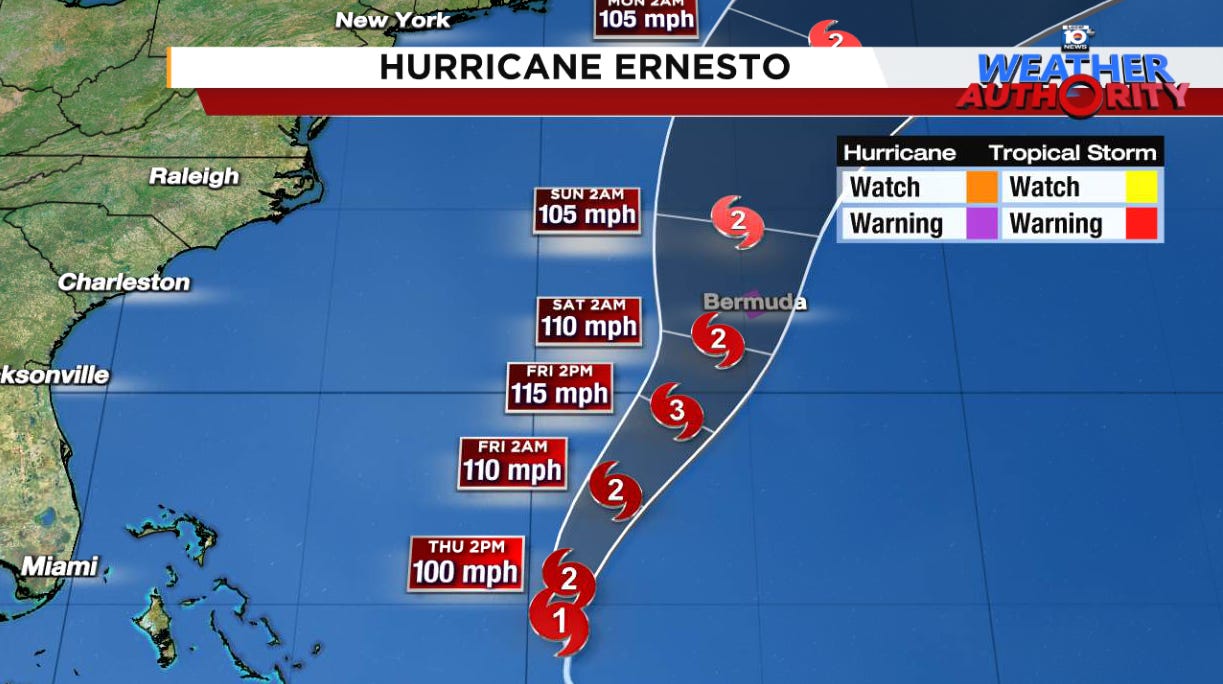
Ernesto continued to strengthen on Thursday morning as it churned northward into the Atlantic about 250 miles northeast of the Turks and Caicos and the southeastern Bahamas. The hurricane is forecast to pass dangerously close to Bermuda by Saturday as a strong Category 2 hurricane. Hurricane warnings are in effect for Bermuda for the expectation of 74 mph winds or stronger as Ernesto draws near.
While Ernesto’s organization has gradually improved, its large and open eye have allowed for some dry air to mix into its core, stifling a more rapid pace of strengthening courtesy of light upper-level winds and very warm seas.

Bermuda’s hurricane history
It’s been nearly four years since the last Category 2 or stronger hurricane struck Bermuda. The cloud-free eye of Category 2 Hurricane Paulette moved square over the northeastern portion of the archipelago during the predawn hours on September 14, 2020, knocking out power to the entire island, though only minor damage was reported.
Bermuda, at only 21 square miles, is about one one-hundredth the size of Miami-Dade County. This small speck some 750 miles east of the Carolinas in the middle of the vast Atlantic is no stranger to hurricanes, however. On average, a Category 2 or stronger hurricane passes to within 25 miles of Bermuda about once every 10 to 12 years. Most strong hurricane impacts have historically come in September and October, not August, so Ernesto is a notably early threat.
The British Overseas Territory has a notoriously hearty infrastructure that has withstood some stinging strikes in recent decades. Despite numerous strong hurricane hits this century, it’s been over 20 years (since Fabian in 2003) that a hurricane-related death has been reported in Bermuda.
Threat of dangerous and life-threatening surf and rip currents along the U.S. East Coast
As we detailed in yesterday’s newsletter, Ernesto is expected to produce a wide area of swell that will spread toward the U.S. east coast starting in earnest on Friday and continuing into the weekend.
Beachgoers from the Carolinas to the mid-Atlantic northward to New England will see dangerous surf conditions and the risk for life-threatening rip currents in the days ahead.
Rip currents – strong channels of water that can pull even the best swimmers out to sea – are already responsible for some 30 deaths nationwide so far in 2024. Rip currents are a silent killer and according to the National Weather Service have killed more people on average each year in the past decade than any other hazard except for heat and floods.
Always mind the red flags and swim only at guarded beaches if you’re headed out to enjoy the warm summer waters.
Tropics quiet into next week behind Ernesto
It appears the tropics will stay surprisingly quiet into next week in the wake of Alberto. Despite low wind shear and a very warm Atlantic, the systems rolling off Africa are hitting the Atlantic at a higher latitude than usual and getting mixed up in some lingering Saharan dust and dry air.
As we’ve discussed in previous newsletters, dust naturally declines this time of year headed into the hurricane season peak, so it’s overall a non-factor but for now it may help to stave off development odds for another week or so.
A quiet week in August is always a welcome sight so we’ll take it as long as we can get it.


Great information to us non-Mets.
Thanks for the update. Looks like a possible Cat 3 or 4 before it's all over.