October Surprise: Oscar Rapidly Forms, Stuns Forecasters Over the Weekend
A system with a low chance of development Saturday morning suddenly became powerful Hurricane Oscar by Saturday afternoon

It’s not often we see a colossal failure in hurricane forecasting, but over the weekend the sudden formation of Hurricane Oscar on Saturday near the Turks and Caicos off the southeastern Bahamas was a reminder why we watch every system carefully, especially those close to land during the peak months of the hurricane season.
Oscar’s long and largely uneventful journey
The disturbance that became Oscar – designated Invest 94L – was one we’ve been tracking since it emerged off Africa in the last days of Milton over a week and a half ago. Even in those early days, models were hot-and-cold on its development odds, but given the unusual westward trajectory toward the Caribbean for middle October, we advised keeping tabs on it.
By last Friday morning, 94L was passing north of the U.S. Virgin Islands and Puerto Rico. The models that earlier suggested some slow development threw in the towel, and while the system was expected to bring the potential for heavy rainfall to parts of Hispaniola and eastern Cuba over the weekend, not a single forecast model indicated possible development. Though intensity guidance showed a brief window of conditions that could favor formation, by the weekend, an onslaught of wind shear was expected to quickly shut it down.
None of this happened and within a 12-hour period beginning early Saturday, 94L went from a yellow circle on NHC’s outlook map to Category 1 Hurricane Oscar, quickly skirting the Turks and Caicos late Saturday before striking Great Inagua Island in the Bahamas and the northern coast of eastern Cuba on Sunday.
Though Oscar officially peaked as a Category 1 hurricane this weekend, very-high-resolution wind estimates derived from low-earth orbiting Canadian satellites suggested it could’ve been as strong as a Category 2 or 3 hurricane before striking the tip of eastern Cuba Sunday evening.

Because Oscar was such a small hurricane, traditional satellites struggled to estimate its strength and hurricane hunters investigating the hurricane Sunday morning ended their mission before the hurricane likely peaked, so we may never know how strong Oscar actually got (note: Synthetic Aperture Radar or SAR wind estimates from the previously mentioned Canadian RCM satellites have historically run high higher than what’s been observed by hurricane hunters).
Oscar the smallest hurricane ever recorded
The reason computer models missed the rapid development of Oscar was because the hurricane was so small. When it formed on Saturday afternoon, hurricane hunters measured the extent of Oscar’s hurricane wind field at only 5-6 miles across.
This not only made Oscar the smallest hurricane of the 2024 hurricane season, but the smallest hurricane ever known, with observational records of hurricane wind fields going back to the mid-1960s.

Of course, there was probably a hurricane as small or smaller than Oscar at some point that we missed, but the idea is that hurricanes of such diminutive stature are extremely rare. Even our most state-of-the art, highest fidelity global forecast models (like the oft-cited European model) can’t “see” weather features that are smaller than 5 or 6 miles in size (it’s why we can’t forecast individual tornadoes, only the overall setup that can lead to big tornadoes), so it’s no wonder they missed Oscar.
It's also why hurricane hunters fly so often into developing tropical systems. Once hurricane hunters flew into Oscar’s micro core, that data was not only relayed back to the National Hurricane Center to inform their forecasts but ingested into computer models, which finally allowed the models to see the hurricane they didn’t know was there.
Nightmare fuel for forecasters
Although Oscar plinkoed into several islands as it spun up this weekend, because its hurricane wind field was so small, the extent of the wind damage was very limited. The bigger impact is the heavy rainfall and significant flash flooding that it continues to deliver today across eastern Cuba and the southeastern Bahamas.
Nevertheless, Oscar is a good reminder that as accurate as hurricane forecasting has become, models can still miss egregiously on occasion. We saw something similar happen only 4 weeks ago in the eastern Pacific when a system that wasn’t even on NHC’s Tropical Weather Outlook within 60 hours struck as major Hurricane John just east of Acapulco in southwestern Mexico.
Rapidly strengthening hurricanes near land that go largely undetected by models are nightmare fuel for forecasters, and an area we continue to research to better understand and work to mitigate.
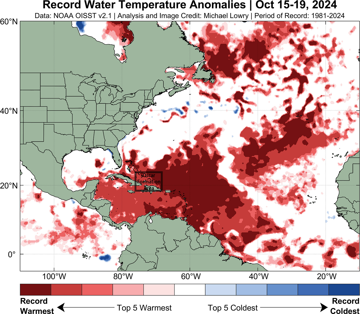
It’s also worth noting that Oscar moved over some of the warmest waters on record for the time of year, another important factor driving its rapid formation.
No new systems behind Oscar but watching the Caribbean again for next week
Oscar will continue to weaken today and tomorrow as it finally feels the impact of increasing wind shear. Nevertheless, heavy rainfall and widespread flash flooding will persist for eastern Cuba and the southeastern Bahamas before the remnants of Oscar get absorbed by a larger frontal system and accelerate into the north Atlantic by mid week.
Oscar poses no threat to the U.S.
This week should be mostly quiet in the tropics behind Oscar. As we alluded to in newsletters last week, another conducive MJO pulse will move into the Atlantic starting next week. As a result, long-range models suggest more Caribbean mischief as we turn the page to November next week, so we’ll need to monitor the trends.
The good news for us stateside is that increasing wind shear surrounding the U.S. coastline – including here in Florida – typically keep mischief away from our shores by this point in the season, and long-range models indicate that’ll be the case deep into next week.


Wow - like a microcane - looks like this season might produce new terminology. I read once of a 'flash' hurricane. I guess the physics of all this will keep us learning 📚