North Miami and Broward Left Reeling from Relentless Flash Floods
A torrent of tropical rains on Wednesday unleashed a punishing afternoon of floods for metro and coastal Miami-Dade and Broward Counties
The metro and coastal communities of North Miami and Broward County were rocked by rounds of unforgiving tropical downpours on Wednesday which quickly transformed streets into rivers, stranding motorists and causing a cascade of delays and closures along southeast Florida’s bustling I-95 corridor.
By rush hour on Wednesday, the flash flooding has spiraled into an especially dangerous, life-threatening situation, prompting the National Weather Service in Miami to issue a flash flood emergency – a dire and exceedingly rare flood alert sent out only for the most severe threats to life or property – from North Miami to Fort Lauderdale-Hollywood International Airport. The office had only issued a flash flood emergency once before – on April 12, 2023, during the unprecedented Fort Lauderdale floods.

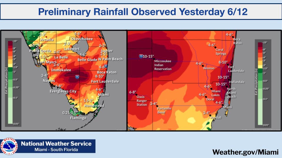
As dusk cast its long shadow across South Florida, the rains began to relinquish. At the end of the day, many areas – including parts of Hallandale Beach, Hollywood Beach, and Aventura – had been flooded by more than a foot of rain since sunrise. Officially, Fort Lauderdale International recorded 9.54 inches of rain on Wednesday, a top 10 daily rainfall event with area records dating back to 1912. In these hardest hit areas, the amount of rainfall measured in such short order on Wednesday statistically has about a 0.5% to 1% chance of occurring in any given year.
It was the third day of a nearly week-long heavy rain and flash flood threat for South Florida. A surge of exceptionally rich tropical air drawn northward from the Caribbean early in the week set the stage, and a stalled front across north Florida teamed up with a broad area of low pressure stretching into the Gulf to open the floodgates.
Since Tuesday morning, 20 inches has fallen across parts of Broward and north Miami-Dade, including Hallandale Beach, Hollywood, and North Miami. In two short days, these areas received as much rain as they might get over an entire summer.
Unfortunately for South Florida we’re only in the middle innings of the heavy rain threat. The National Weather Service is forecasting up to another 4 to 8 inches, with amounts locally as high as 10 inches, through Friday evening. With saturated grounds and standing water still in neighborhood streets, it won’t take nearly as much rain as what we saw Wednesday to cause additional flooding. The Flood Watch remains in effect through Friday.
Hurricane Hunters set to investigate 90L Thursday afternoon
While the flooding on Wednesday wasn’t officially from an organized tropical system, a broad area of low pressure – designated Invest 90L by the National Hurricane Center – sliding along a stalled front hastened it.
This low-pressure area is now off the northeast coast of Florida where NHC is indicating a small window for development over the next day or two before it quickly turns extratropical.
Air Force Hurricane Hunters are scheduled to investigate the system this afternoon, if necessary. The long tail of moisture from 90L will continue to affect our weather for the remainder of the week, but the system is otherwise no threat to the U.S.
Odds increasing for development in the Bay of Campeche next week
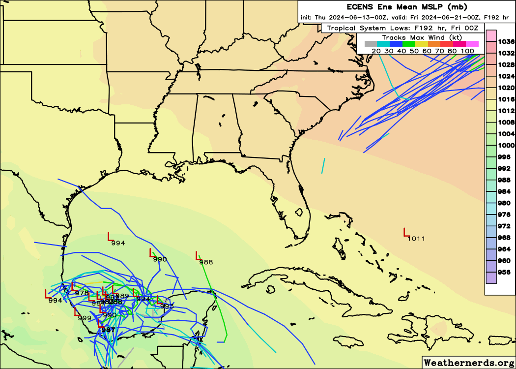
On deck in the tropics is an expansive area of spin across Central America that may make a run at consolidating into an organized tropical system early next week in the extreme southern Gulf of Mexico or Bay of Campeche.
While the environment appears conducive to development, a high pressure heat dome anchoring over the eastern U.S. – bringing the possibility of triple-digit temperatures to many locations – will block anything that forms from moving east toward South Florida.

The first name on the list is Alberto.


Thankfully I've not been affected beyond drenchings between vehicle and buildings. It has been SO MUCH WORSE for so many folks.
Thank you for continued factual reports.
I am sorry for those worst affected by these rains, Somehow we managed to miss the heaviest rain it going both north and south of us.