It's Saharan Dust Season, but Where's the Dust?
A non-tropical low pressure system near the Azores may try to leverage the ongoing Atlantic heatwave this week

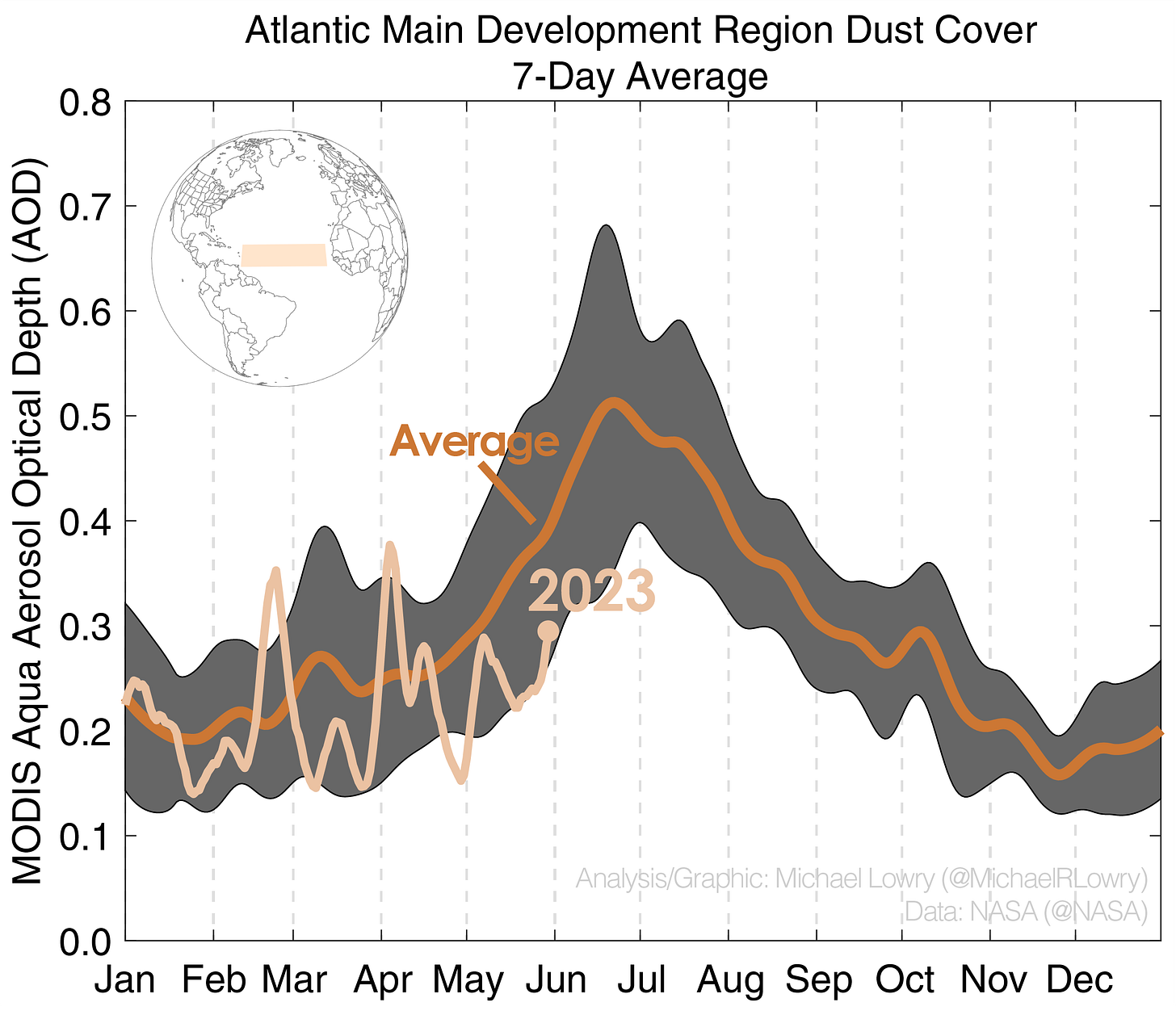
By late spring into early summer, we typically begin to see big outbreaks of the Saharan Air Layer or SAL – massive plumes of mineral dust from the deserts of north Africa lofted upwards of 15,000 feet – strewn thousands of miles westward through the Atlantic, occasionally reddening the skies here across the Gulf Coast states. By this point in 2022, we’d already seen one of those widespread dust storms reaching the sands of South Florida. So far this spring, however, our skies have been noticeably free from the Saharan haze.
Not surprisingly, the same is true across the main development region of the Atlantic Ocean – the part of the deep tropics where most Category 3, 4, and 5 hurricanes form later in the season.
The SAL – affectionately coined “our pal SAL” by meteorologists for its storm-busting potential – is traditionally seen as an early season hurricane deterrent. Would-be tropical storms and hurricanes thrive off soupy tropical air, especially at the middle part of the atmosphere where the SAL looms large. It stands to reason in the presence of dry, dusty desert air, storms will struggle.
Perhaps no coincidence, the SAL naturally subsides right as the peak of hurricane season ramps up, so in the aggregate the amount of dust early in the year doesn’t tell us much about what may come later in the season. In fact, African Easterly Waves – the seedlings that become some of our strongest hurricanes by late summer and early fall – are the primary vehicles that transport dust across the Atlantic. Low dust may suggest less robust tropical waves for now.
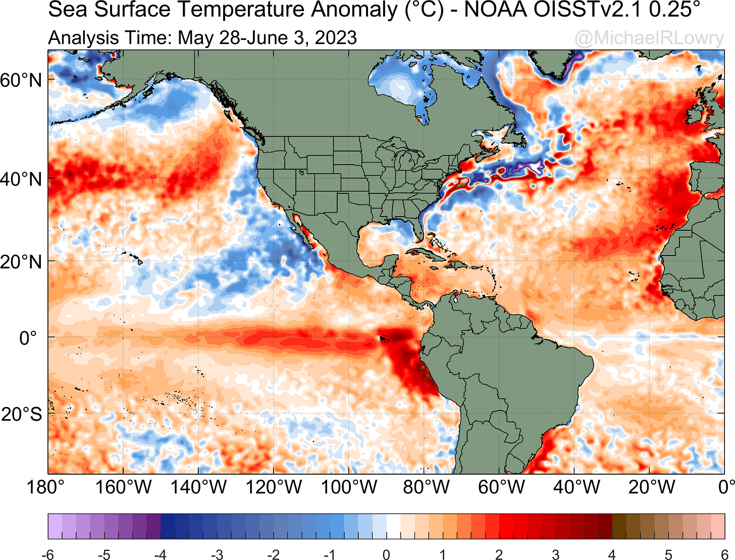
Regardless, the low dust concentrations so far could be compounding the pronounced warming trend across the Atlantic.
Previous studies have found the presence of dust can have a significant cooling effect on the tropical north Atlantic, especially this time of year. As we discussed in last Thursday’s newsletter, the tropical north Atlantic is experiencing a heat wave like few others we’ve seen in decades, complicating seasonal hurricane forecasts in 2023.
Over the weekend, we bid adieu to Arlene in the eastern Gulf, which has allowed for a drier start to the workweek across South Florida.
The only area being monitored this week in the Atlantic is some 3,000 miles to our northeast near the Azores.
Because of the abnormally warm waters in this part of the Atlantic, a non-tropical low pressure area has a low chance of transitioning into a subtropical system in the next day or two. The development window is narrow, however, as it will be moving into cooler waters by the end of the week.


Well, you never know. A non-tropical low that far north can surprise you the way Arlene did; and it's debatable as to whether Arlene should have been named yet; but then again a january sub-tropical storm didn't get a name and maybe it SHOULD have, but maybe the NHC didn't want to name it for frar of criticism of naming it since it was January and not June. Too keep folks happy, they likely decided not naming that borderline storm. I am sure they get SOME flak for doing just that; naming SOME borderline hybrid storms.