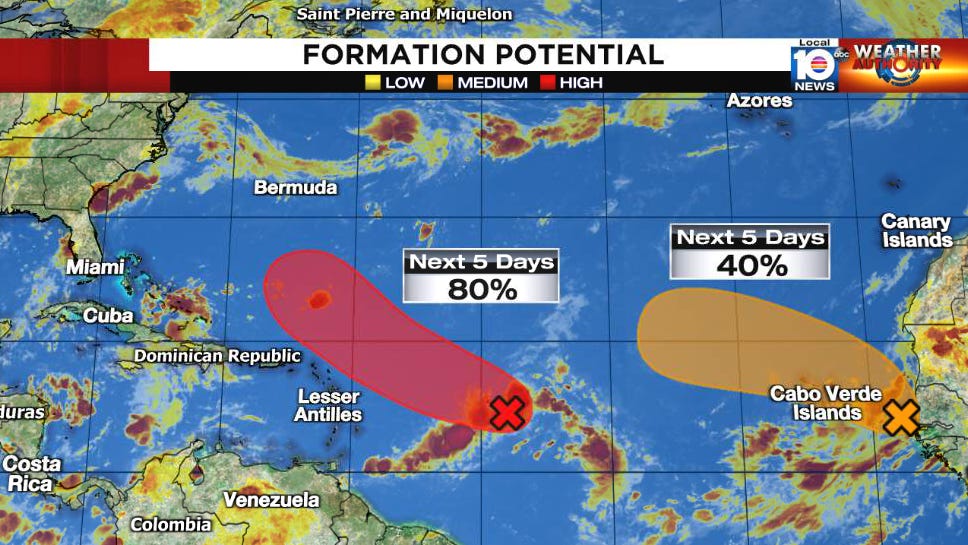
In a year when everything’s seemed to struggle, when the Atlantic’s gone an incredible 59 days and counting without a recorded tropical cyclone, in likely the first season without a hurricane through August since 2013 and perhaps even the first season since 1997 without an August tropical cyclone of any kind, it’s no surprise Invest 91L – the central Atlantic disturbance garnering high development odds – is struggling to organize.
Although showers and thunderstorms percolated around 91L overnight, the storminess remains disjointed on either side of the still-broad and elongated low pressure circulation. Dry air is a big obstacle for the disturbance to overcome in the days ahead, and, due to the difficult environment, only gradual development is expected.
Another positive development over the last 24 hours has been a general trend toward a much slower-moving and poleward-seeking system down the line. This is shifting the threat away from the southeastern Bahamas and Turks and Caicos.

Additionally, dozens of dropsonde observations from yesterday’s high-altitude hurricane hunter mission were assimilated into the overnight global forecast models. While interests in the Bahamas will want to stay atop the latest forecasts, the added data and better model agreement should help our neighbors breathe a little easier today.

For us in South Florida, 91L isn’t an immediate concern for now. With dry air woes continuing to delay near-term formation and hostile wind shear cranking up in a few days, the disturbance has some work ahead. A dip in the jet stream by late weekend looks to weaken high-pressure steering and open a channel for 91L to begin to pull northward early next week. We’ll keep an eye to the trends – as we’ve discussed in previous newsletters, forecasts this far out are subject to large errors – but for now the trend is our friend.
Elsewhere in the tropics, we’re watching another tropical wave roll off Africa. Some development is possible with this one, but the conducive environment may be short-lived as it moves deeper into the Atlantic. Either way, it’s no concern for us in South Florida this week.


OK, a couple of things to note: The system may be struggling, but there's the meteorologist Joe Cioffi who thinks this sytem COULD become at LEAST a tropical depression, maybe a weak storm in the next day or two. Yes, the thunderstorms are more organized, as Mr. Cioffi discussed this morning on You Tube; an upper level low DID move slightly southwest and slightly away overnight. The amount of dry air has been forecast by the global models to finally dissipate SOMEWHAT in coming days. This has allowed the intensity forecast to show a Cat 1 hurricane in a few days, but this mornings forecast has backed off from Cat 2 possibilities, and more models are taking it to a Cat 1 or a storm than last night when they were pointing to a Cat 2 solution. You seem to argue that dry air will continue to be an impediment, but Mr. Cioffi does agree with the prospect of the weakness in the high; so there's no reason to believe now there will even be a hit on the Bahamas. This looks to be a fish storm, regardless of whether it gets a name or not. There would be no interference with the next scheduled space launch attempt for Artemis 1. Yesterday I was wondering if there might be some effects, but it appears now that Artemis 1 won't be affected, so that's good news. The bad news is they may need to take Artemis 1 into the shop for maybe a month or two engine repairs if the leak problem is not solved this week. Anyway, Artemis is a whole "nother story. The tropics are important right now, not just Artemis.