


Hurricane Season is Here: What We're Watching for Week One and Beyond
The 2025 Atlantic hurricane season began Sunday and runs through November 30th


For newsletter subscribers: Today we resume the daily Talking Tropics newsletter. The goal of the newsletter is to alert you first to any signs of tropical trouble in the Atlantic. On days when the Atlantic is less active, I’ll share unique insight and one-of-a-kind analyses about the developing season you’ll only find here. The newsletter arrives in your inbox promptly each weekday morning (and on weekends, as conditions warrant) throughout hurricane season.
This is the 400th post of the daily newsletter and the 4th consecutive hurricane season since its inception. Thank you for your support and growing readership that have made this publication a trusted source of no-hype hurricane forecasts and information. Feel free to search any previous posts available on our extensive Substack archive. -Michael
It’s the opening week of the 183-day Atlantic hurricane season, which runs from June 1st through November 30th. The good news right off the bat: no development is expected for the first full week of the season.

The tropics aren’t always so kind. In fact, in 8 of the past 10 hurricane seasons, we’ve seen the first tropical or subtropical storm before the official June 1st start.

Most typically over the past 50 years, the first named storm has formed around the second week of June. Hurricanes, however, usually take a little longer to surface. Though every season is different, we typically don’t see the first hurricane formation in the Atlantic until August.
The Atlantic hurricane season ramps up quickly deep into the summer and early fall, with August, September, and October being its most active months.

The first name on the list in 2025 is Andrea.

First shot of Atlantic activity comes mid-June
The Atlantic is closed for business for at least the next week to week and a half. Upper-level winds are characteristically harsh through the preferred formation zones this time of year nearer to the U.S. and Central America.
A blanket of thick Saharan dust has also spread through much of the deep tropics, which will also deter organized storminess for the near term.
As we approach the middle part of the month, the upper wind pattern will change as a pulse of storminess – known as the Madden Julian Oscillation or MJO – crosses into the Atlantic from the eastern Pacific.
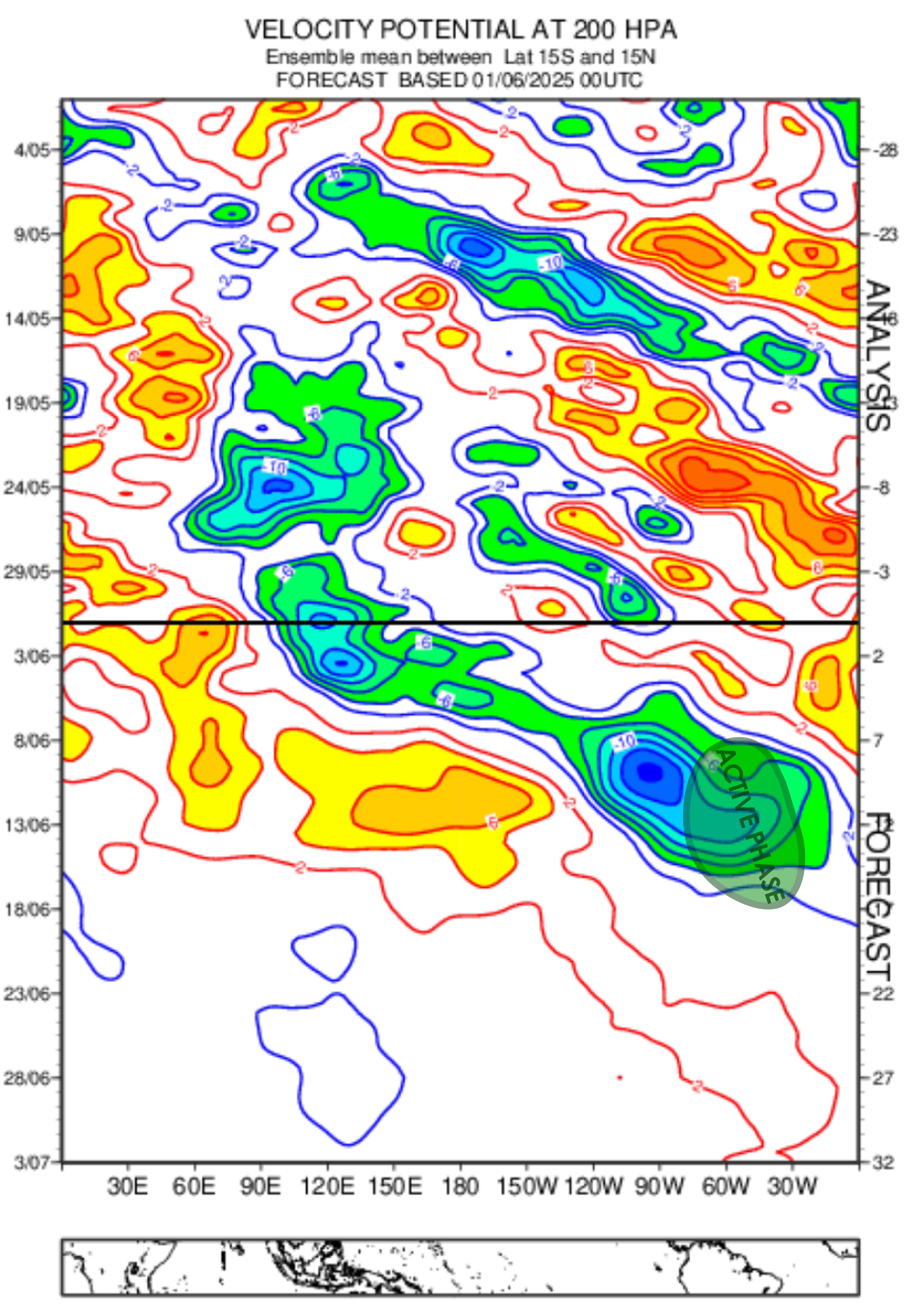
We should see a configuration that’ll favor storminess around Central America by late next week into the weekend of June 14th.
It’s too early to know if the configuration will favor development on the eastern Pacific or Gulf/Caribbean side of Central America and Mexico, but the changing wind pattern should help to activate the Central American Gyre or CAG, a well-documented pathway for storm development in May and June.
Buyer beware on the American GFS
That said, be wary of the American GFS model forecasts beyond 4 or 5 days in the western Caribbean and Gulf. The model has a known bias in this part of the world and tends to “snowball” scarycanes due to an unrealistic feedback loop of storminess and spin off Venezuela.
You can see this plainly from last hurricane season in the verification numbers for the American GFS, which shows all of the instances the model forecast storm formation where it didn’t actually occur, as denoted by the X’s in the plot below.

In contrast, the European model had a much more consistent track record Atlantic-wide, but especially in the western Caribbean, where more often than not the model accurately forecast formation (indicated by the circles).
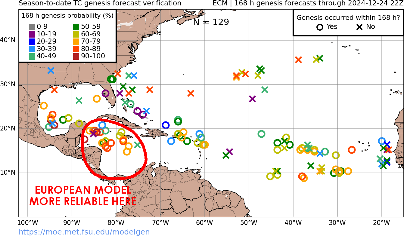
The American GFS may be correctly sniffing out a more conducive upper-wind configuration in a few weeks that could increase storminess in the western Atlantic, but it’s surely overdoing the results. It’s not a credible forecast solution so don’t buy into the hype.
Stay aware, stay informed, and be ready for your one, should this year be the one.
Thank you for the GFS and Euro model origination; that's a drastic difference.
It's June 7, and there's still a big storm on the GFS! I'm wondering if it knows something the other models don't. Yr. thoughts, Michael?