Hurricane Francine Hits, Unleashing Extensive Flooding Across Southeastern Louisiana
Flood threat continues today for Mississippi, northern Alabama, western Tennessee, and the Florida panhandle

Hurricane Francine made landfall in southern Louisiana on Wednesday evening as a 100 mph Category 2 hurricane, becoming the 7th hurricane to strike the state in 7 years and the first Louisiana hurricane landfall since Category 4 Ida struck in August 2021.
Francine became the third mainland U.S. hurricane landfall of an impactful 2024 hurricane season. Only 8 other hurricane seasons since 1900 have had as many mainland U.S. hurricane hits by September 11th.
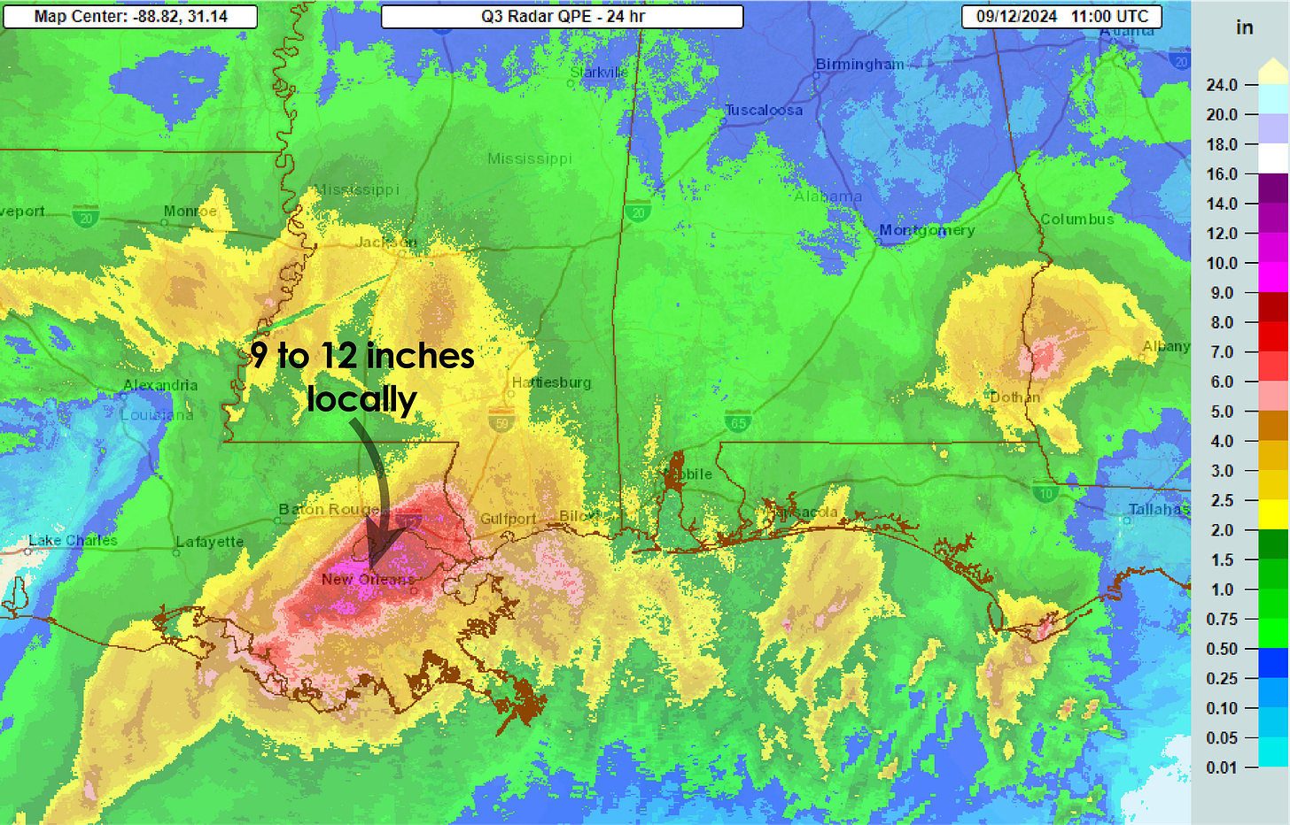
Francine jogged east as it moved inland, which brought its dangerous eyewall and torrential rains over the populated New Orleans metropolitan area shortly after sunset. Widespread rainfall totals approaching double-digits consumed the New Orleans metro and its neighboring River Parishes, where rain rates exceeding 2 to 3 inches per hour led to the issuance of a rare flash flood emergency for Greater New Orleans.

Widespread flooding of homes and neighborhoods was reported throughout the metro area Wednesday night as emergency crews scrambled to rescue stranded residents and motorists. Winds gusted to 78 mph at New Orleans International Airport, cutting power to over 100,000 metro New Orleans customers, as the heavy rains overwhelmed drainage pumps and canals overflowed their banks.
Winds gusted up to 105 mph at a coastal station near Eugene Island where Francine came ashore in south-central Louisiana around 5 PM local time yesterday. At a station in nearby Dulac south of Houma, Louisiana, wind gusts reached 96 mph.
As of daybreak Thursday, nearly 400,000 customers across southeastern Louisiana remained without power.
Francine quickly losing tropical characteristics but heavy rain threat continues inland
Although Francine is quickly shedding its tropical identity as it moves farther inland over Mississippi, the storm system continues to spread extensive heavy rains into northern Mississippi, Alabama, western Tennessee, and as far east as the Florida panhandle.
Double-digit rainfall totals are again possible today, especially across northern Alabama, including Birmingham, where the National Weather Service is forecasting a moderate risk of excessive flooding, indicating the possibility of considerable flash flooding during the day.
The risk of flooding will continue to spread east through the Tennessee Valley and into north Georgia on Friday and Saturday as Francine’s remnants get absorbed by a stalled front.
Tropical Depression Seven forms in the eastern Atlantic
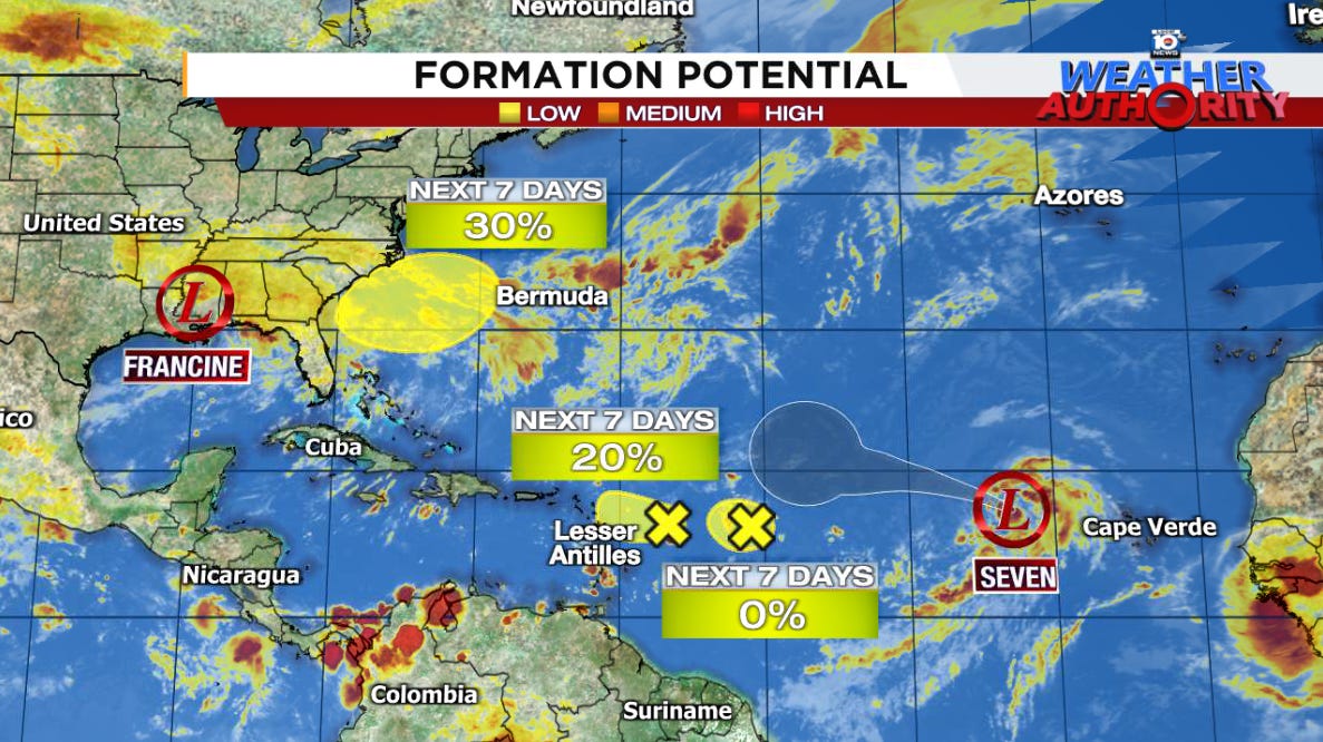
Tropical Depression Seven formed late Wednesday morning in the far eastern Atlantic several hundred miles west of the Cabo Verde Islands off Africa. The systems is forecast to become Tropical Storm Gordon today, but little strengthening is expected into early next week. Forecast models curl the system into the open central Atlantic next week, and it isn’t expected to pose any threat to land over the coming week.
Two feisty disturbances east of the Caribbean islands – designated Invest 92L (easternmost) and 94L (westernmost) – continue to struggle with maintaining persistent thunderstorm activity in the presence of nearby dry air. Only a small window for development exists for Invest 94L today into tomorrow, and regardless neither poses a significant threat as they approach the northeastern Caribbean islands this weekend.
Watching off the southeast U.S. to start next week
As we’ve previewed in newsletters this week, a stalled front draped over the waters off the southeastern U.S. could become the focus for an initially non-tropical area of low pressure to form by late this upcoming weekend. Some of our forecast models show the non-tropical low gradually acquiring tropical characteristics on Monday into Tuesday as it drifts back toward the Carolinas.
For now at least the threat remains low, but we’ll continue to follow the trends into the weekend.


In Gulf Shores on the Alabama coast we had a significant feeder band starting 9-10+ pm and I’d guess 30-40 mph gusts, sporadic heavy rain and a tornado watch. Went on for hours.The beach is scoured clean this morning. All in all everything looks good. Heartfelt wishes to LA folks.
Some people keep complaining saying the meteorologists are needlessly scaring people with their predictions of this year's hurricane season but are ignoring the fact that of the few named storms so far 3 of them have hit the US mainland. That is highly uncommon as some seasons are active yet none hit the US mainland at all and we still have the worst of the season to get through.