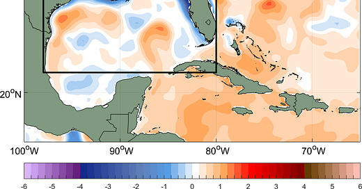
Gulf of Mexico Cooling Off
NHC highlighting three areas this morning, but none poses any immediate threat
With some uncommon exceptions like the 1935 Yankee Hurricane that struck Miami Beach on November 4, 1935, most October and November South Florida storms arrive from the Gulf side, not the Atlantic side. Fall fronts can effectively pick up storms out of the Caribbean and usher them our way, assuming conditions still permit organized tropical cyclone activity.
For now, however, the Gulf of Mexico has become a very unfriendly place for tropical cyclones. Storm-smashing wind shear was running near record lows in the days prior to Hurricane Ian’s devastating southwest Florida strike on September 28th but has since skyrocketed to near record highs for the time of year, on par with windy El Niño years like 1986, 2015, and 1997.
Wind shear averaged across the Gulf of Mexico at almost 70 knots almost guarantees we won’t see any nearby late season tropical threats anytime soon.
As Ian churned up cooler waters from below in the eastern Gulf and a series of cold fronts followed, water temperatures also dipped noticeably beginning in October, especially in shallower shelf waters surrounding the coast. Sea surface temperatures fell below average for the first time all year over the past few weeks and overall the Gulf hasn’t been this cool since May.
For the cooler shelf waters around Florida’s western peninsula, we’d have to go back to April to find waters falling into the upper 60s as they are this week.
All-in-all the developments in the Gulf should give us some comfort heading into the final month of the hurricane season.
While the NHC is monitoring three possible areas for possible development this morning, none poses any immediate threat. As we discussed in Sunday’s newsletter, our forecast models suggest some storminess in the Caribbean as we move into next week, which NHC is now highlighting, but the upper pattern should keep the stormy activity well to our south and east for the time being.


