
Forecasters Issue Revised Hurricane Season Outlook
Colorado State University nudges numbers down but still calls for a slightly above average hurricane season


Author’s note: The data used to create the analyses (including charts and maps) included in today’s newsletter come from the National Center for Atmospheric Research or NCAR, a federally funded nonprofit research center headquartered in Boulder, Colorado. The Trump administration submitted a budget request at the end of May which slashes NCAR’s funding by 40%, jeopardizing these critical data streams regularly used by scientists and forecasters.
Forecasters at Colorado State University – the pioneers of seasonal hurricane forecasting – issued their July outlook for the hurricane season, nudging down numbers from their April and June outlooks, but still calling for a slightly above average season overall.
The team of hurricane researchers predicts 16 named storms (including the three already observed), 8 hurricanes, and 3 Category 3 or stronger hurricanes (winds of 111 mph or higher) in 2025. This is near but just above the 30-year hurricane season average of 14 named storms, 7 hurricanes, and 3 Category 3 or stronger hurricanes.

The CSU team also pared back predictions of a hyperactive season, dropping Accumulated Cyclone Energy or ACE numbers from 165 to 145. The ACE score is the hurricane season’s grading scale, with higher numbers indicating stronger, longer lived storms. On average, the seasonal ACE score is 123, with hyperactive seasons having ACE scores of 155 or higher. In 2024, Atlantic ACE was 162, making it a hyperactive season.
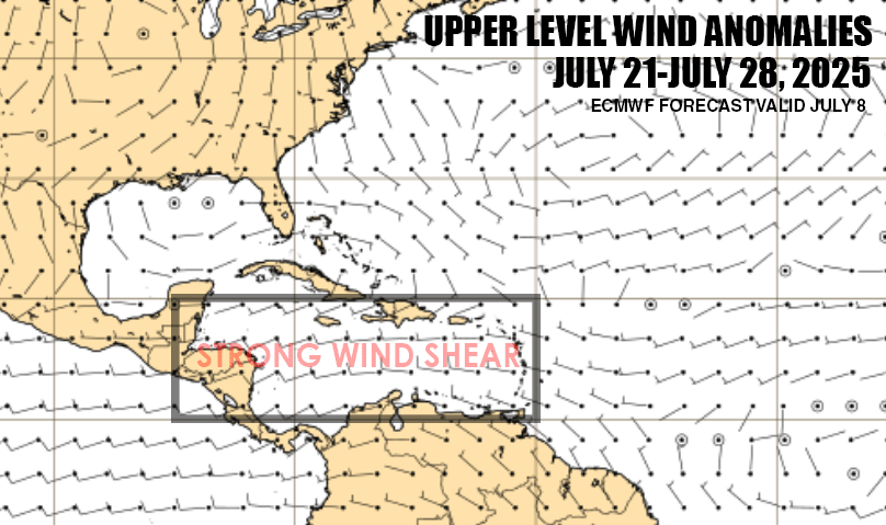
Hostile wind shear pumps the brakes
The main factor the CSU experts cite for their tick down in numbers is observed and predicted wind shear, much higher than average, especially in the bellwether Caribbean region.


Their research shows that Caribbean wind shear has a negative relationship to overall Atlantic hurricane activity – that is when Caribbean wind shear is high, basinwide hurricane activity tends to be reduced. An important caveat, however, is this relationship only holds from July onward. June shear in the Caribbean doesn’t count for much.

A wind shear reversal by August?
Though models show the shear sticking around for the next few weeks, they do show a noticeable reversal of upper-level winds, the primary driver of wind shear, come early August.
This change in upper-level wind pattern could be a byproduct of a strengthening Madden-Julian Oscillation or MJO, something we touched on in yesterday’s newsletter, bringing enough vigor to the Atlantic to scour away at some of the less conducive conditions we’ve seen so far this season.
This is certainly one of the more significant signals we’ve seen yet in the Atlantic, so it’s worth following to see models start perking up as we turn the calendar to what’s traditionally the busiest stretch of the hurricane season.
Slow goings for now
Forecast models are lackluster for the next few weeks, with slow goings across the tropical belt of the Atlantic.

The only activity besides Barry we’ve seen so far in the Atlantic has come from outside the tropics, so we’ll keep an eye out for any suspicious areas along dying fronts. For now, we don’t see any concerning areas into at least the early part of next week.
The new CSU seasonal forecast is a classic CYA by going 'middle of the road' on their 'old forecast and what the current metrics suggest is a below normal season.
Near and even below average SST's for the date in many areas of the MDR - and certainly cool by recent years' standards. Even tho the GOM is warmer than average (as are SSTs off the SE US coast), the higher REZ data barely notices the Gulf Stream (using SST's within it as a reference) - let alone any significant Loop current. I can't really recall seeing something like that in decades! The cooler SST's compared to recent years is also holding down instability & related convection - even within the ITCZ at times and especially across the MDR in general. And for the time being ENSO is essentially neutral and forecasting MJO intensity is a low skill endeavor beyond 2 weeks.
For a number of reasons - including the above -I suspect we'll see more named storms than normal, with 6 -7 of them reaching Hurricane intensity and a season ACE around 110-125.
If you want full funding for what you believe to be essential forecasting tools, then make suggestions on other areas to cut to provide said funding. The U.S. is nearly $37 TRILLION in debt. We are taxed enough.y suggestion is to remove ALL "pure-COVID-related" spending. That era is over, but the $100s of BILLIONS remain in the federal budget. This is ludicrous!!!!