Fall Fronts Guarding the U.S. from Developing Systems this Week
Cold fronts finally clearing South Florida offer more than just relief from the heat
Back at the beginning of October, we discussed what we anticipated to be a formal transition to dry season across South Florida around the middle of the month. As we detailed, the eagerly-awaited switch from South Florida’s rainy season to dry season isn’t only a boon for us in South Florida but an important milestone for all Americans living at the head of hurricane alley.
Historically, in 9 of 10 hurricane seasons over the past 60-plus years, the last mainland U.S. hurricane of the season has hit before the start of South Florida’s dry season.
This week we see why the drier and (marginally) cooler weather in South Florida is an important step in finally lessening the barrage of hurricane threats of the past month.
Invest 94L to pass near or north of the islands beginning Friday
Invest 94L – a well-defined area of low pressure moving through the central Atlantic – has a modest chance of development as it tracks westward toward the northern Caribbean islands later this week and over the weekend.
The system already has a decent circulation with it, but dry air has limited the extent and organization of thunderstorms. As it moves into a more moisture-rich and thermodynamically robust environment (a region of tropical-laden air and warmer waters) Thursday and Friday, we’re likely to see a more concerted run at development.
It wouldn’t take much in the way of organization to see a tropical depression or Tropical Storm Nadine form in the coming days.
Could 94L or future Nadine threaten the mainland U.S.?
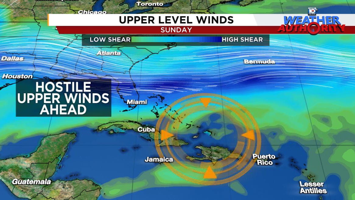
Here’s where the kryptonite of South Florida’s dry season kicks in. The reinforcing cooler and drier air that come with cold fronts sliding through South Florida also increase wind shear along U.S. shores in the wake of big fall frontal passages.
Additionally, jet stream dips that usher through frontal passages in Florida help to steer approaching systems – especially those approaching from the Atlantic like 94L – away from the U.S.
This is what we expect for 94L or future Nadine. As it nears the western Atlantic on Sunday into Monday – either near or over Haiti and the Dominican Republic – it will slam on the brakes as it hits the front that’s reaching into the Caribbean and western Atlantic waters.

Models suggest two outcomes: it dives south and west and weakens into the teeth of hostile wind shear or it’s flung quickly northeast and away from the mainland U.S. In both cases, the states are spared any threat.
That said, we’ll need to monitor the trends for Puerto Rico and the U.S. Virgin Islands this week – mainly for the possibility of heavy rains if 94L or what comes of it tracks near the U.S. territories. The system may also pose a flood threat to Haiti and the Dominican Republic into early next week if it stalls or slows over these island areas.
Western Caribbean disturbance quickly buried in Central America
A disturbance that’s part of the broader Central American Gyre or CAG has been marked by NHC for low development odds over the next day or two. In general, models are tepid on anything forming and keep the low-pressure area broad, with limited time for development before the storminess moves inland across Central America.

Regardless, the upshot will be heavy rains and likely flood issues for parts of northern Honduras, Guatemala, and Belize into the weekend.


Ty Mr. Lowry - sure does sound like good news ⚘
Why does the African wave train shut down this time of the year?