Gulf System to Linger, Bringing Rounds of Rain to Florida into Next Week
Kirk cranking up over the open Atlantic, with another east Atlantic system following in its footsteps

The broad area of storminess we’ve been monitoring in the Caribbean has begun to pivot northward into the Gulf of Mexico, where some slow development is possible by this weekend or early next week.
Forecast models continue the trend of pushing development chances back into next week and odds of a coherent storm forming at all this week have ticked down. In general, the environment over the Gulf of Mexico will be only marginally conducive to development, and, as we’ve reiterated in newsletters this week, this isn’t expected to be a Helene scenario that brings a threat of a significant storm or hurricane.
Development into a tropical depression or tropical storm isn’t guaranteed, but if something forms, it will likely be disorganized and lopsided to the east, which will deflect most weather into the eastern Gulf of Mexico and toward the Florida peninsula.

The upshot regardless of development will be rounds of rain pushing across Florida – especially south and east of the panhandle – beginning later this week and possibly lingering all the way through next week. This means an extended period of unsettled weather may be in store for all of us across South Florida.

For now, rain totals being advertised by forecast models over the next week appear modest, but we’ll need to monitor the forecasts for any threat of flooding the lingering system might bring next week.
Dare we say…dry season?
The changeover to dry season is an annual rite of passage that South Floridians eagerly await each fall.
Prior to 2018, the Miami National Weather Service would declare a date each fall that dry season began based on established criteria, but beginning in 2018 they switched to a fixed date of October 15th as a compromise of long-term averages.
In rare instances – like in 1983 and 1993 – we get our first taste of dry, cool fall air in late September. In other years like 1995 or 2007 we have to wait until the first week of November to escape the grip of the thick, summer air. But in most cases, the transition lies somewhere in between.
Tropical systems also can help to usher in or accelerate dry season by October as well. A 2017 study found over a 58-year period, about half of the years examined had a tropical cyclone in the vicinity of the Florida peninsula when rainy season came to an end.
All this is to say, we’re not far away from perhaps feeling some relief to what was the hottest September on record for many locations across South Florida – exceptional heat breaking some records spanning more than 100 years.
In fact, our long-range models suggest our slow-moving Gulf system could even be a conduit for helping to drag down a cold front through South Florida as we get closer to the middle of the month.
This is still 10 days or more out, so perhaps it’s a little premature to get our hopes up, but there’s good support in the models, and the transition is consistent with what climatology says we should expect.
Dry season is also an important milestone for us in South Florida when it comes to hurricanes. As we analyzed a few years back, the last U.S. mainland landfall has occurred by or before the start of South Florida’s dry season in 9 of 10 hurricane seasons over a 62-year period.
Now that’s something to look forward to.
Kirk cranking up and setting late season records
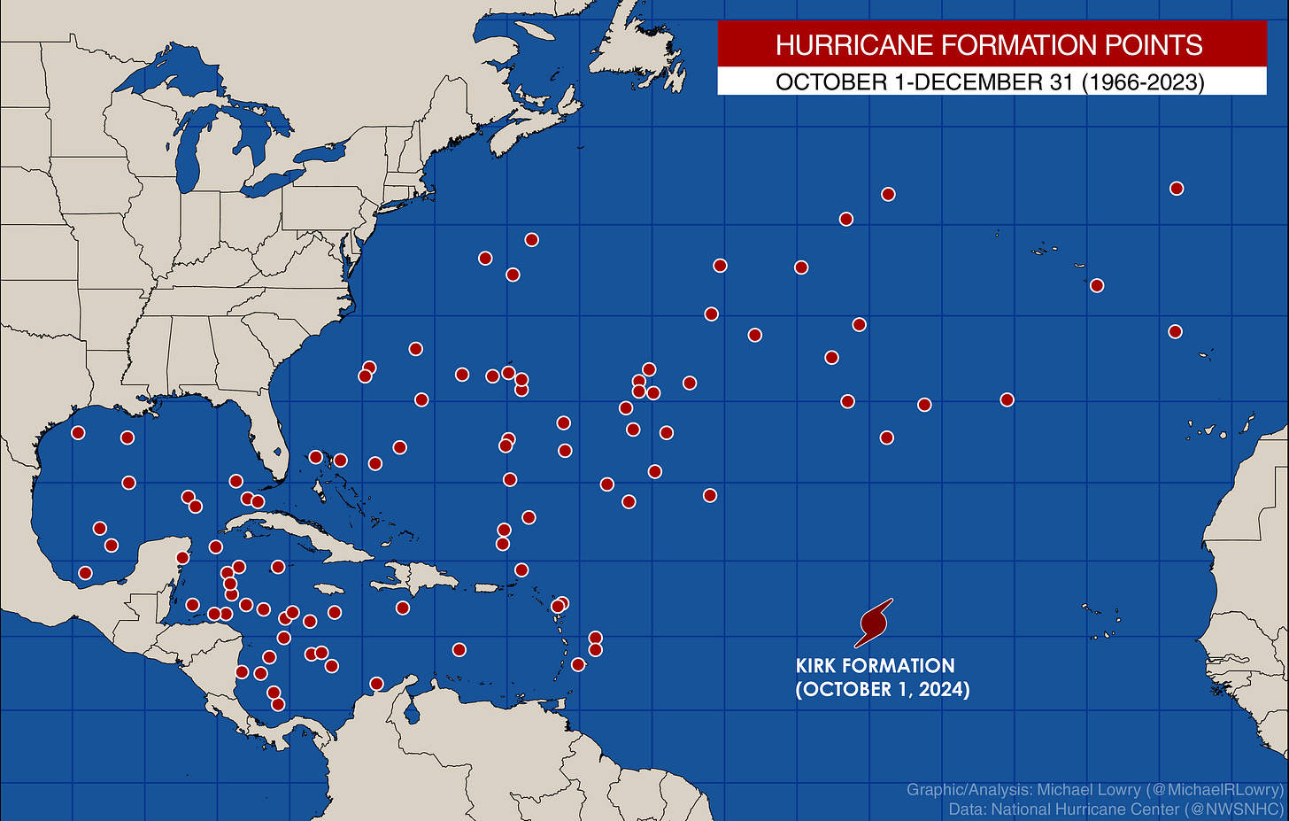
Kirk became a hurricane yesterday afternoon over the deep Atlantic, becoming the farthest east a hurricane has formed this late in the hurricane season in the deep tropics during the satellite era (since 1966).
Kirk is only getting started and is forecast to become a monster hurricane in the days ahead. Fortunately it’s expected to turn over the open Atlantic and the only impacts we’ll see on this side of the Atlantic from Kirk will be high surf along the U.S. East Coast into early next week.
Another hurricane on deck behind Kirk
Forecast models are also bullish on Invest 91L in the far eastern Atlantic as well. Odds are high that a named storm forms over the next day or two and another hurricane looks likely by the weekend.
For the next few days at least the outflow from Kirk will impede quick strengthening. Thankfully, models also turn this one north next week well before it reaches the islands.


Well the Caribbean looks like it will be a rainmaker for mostly south Florida which is good as the northern part of the state can't handle any more right now whereas we can absorb it better. Wish it would cool down soon as Punta Gorda has been hellishly hot and muggy this summer, more than usual.. Hope that hurricane behind Kirk decides to be a fish storm too.