Don't Be Fooled by the July Tropical Head Fake
A late July lull often precedes the most active part of the hurricane season
July is an important transition month for the hurricane season. It’s the month we begin to look farther out into the open Atlantic as more storms form east of the Caribbean than during June.
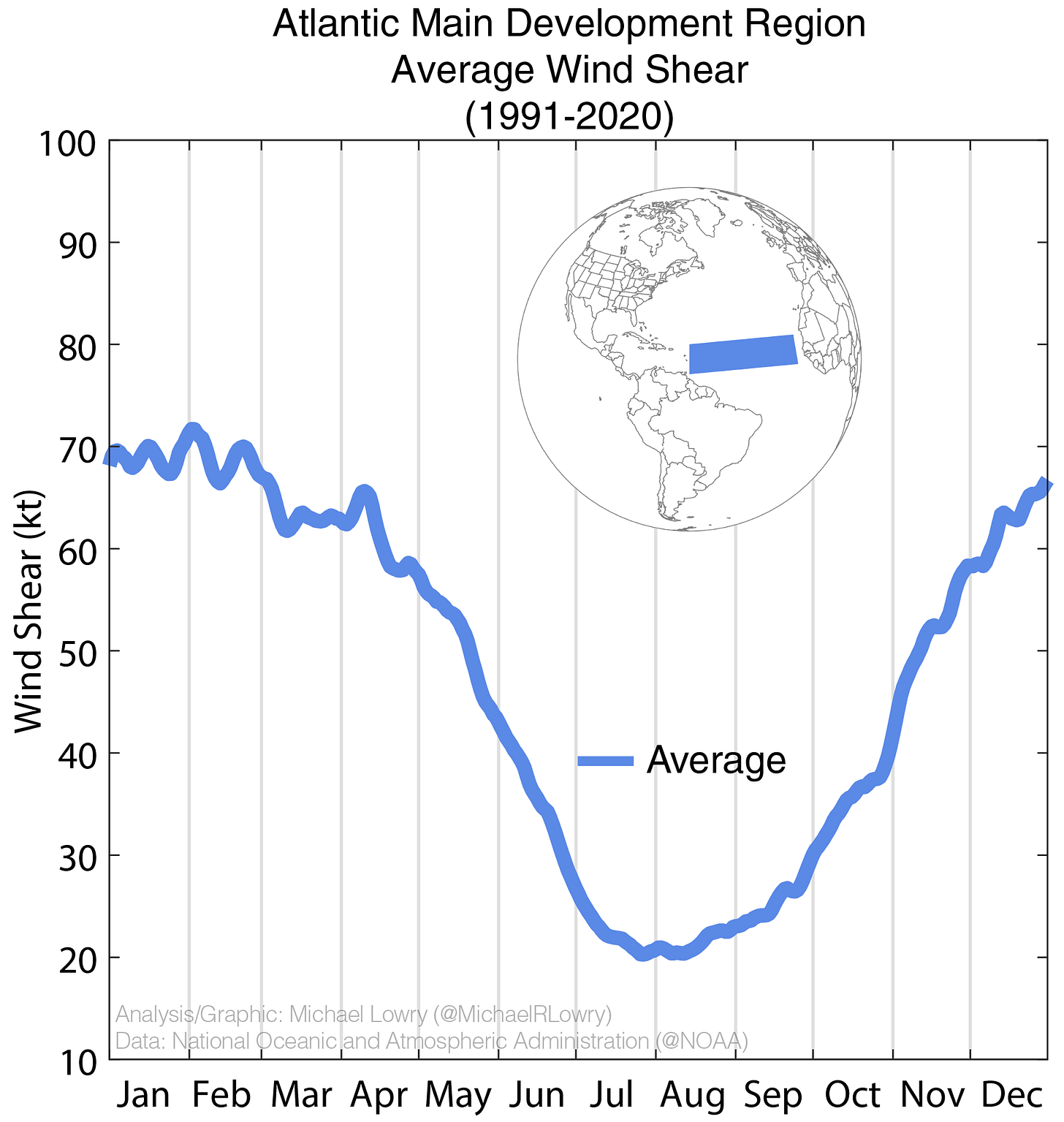
That’s due in large part to a reduction in wind shear – the change in wind direction or strength with altitude – that restricts development in the deep tropical Atlantic to late July, August, and September. Wind shear typically tumbles this time of year to its lowest levels between Africa and the Caribbean and stays mostly within this low range that favors long-lived hurricanes through September.
August begins the so-called Cabo Verde portion of hurricane season, as long-track hurricanes forming near the Cabo Verde islands off Africa become more commonplace.
Although the atmosphere and ocean are quickly getting primed for peak hurricane season, the one ingredient still missing this time of year are strong tropical waves – tropical disturbances that can be seedlings for future hurricanes – rolling off Africa. While the number of tropical waves in the Atlantic increases noticeably from June to July, they’re still relatively weak, preferring tracks north of the Atlantic’s Main Development Region.

Studies have found that only about 12% of tropical waves develop in July compared to 40% in August and September.
But by August and September, the tropical waves crank up, both in number and vigor, preferring a more favorable southern track into the Atlantic Main Development Region, and the storm count in the Atlantic shoots up considerably.

July’s deceiving dip in U.S. tropical impacts
July also tends to see a slight dip in tropical impacts to the U.S. coastline compared to June. We’ve discussed this in detail in previous newsletters and it’s why July is one of the best summer months for a beach vacation.
Of course as Beryl proved last week, hurricanes can happen in any month of the season, but the July dropoff that can extend into early August is the Atlantic’s ultimate head fake before things really take off later in August. Don’t let the lull fool you into thinking the race is over when the tallest hurdles are still ahead.
No storms in sight this week
As we discussed in Monday’s newsletter, the Atlantic is plagued by Saharan dust and sinking air which means the tropics are closed for business this week.
Our forecast models show a whole lot of nothing for the next week or two, which we’re always glad to see.


My best guess is fewer but more powerful storms this year. I suppose the Saharan dust keep a lid on things for a while yet.