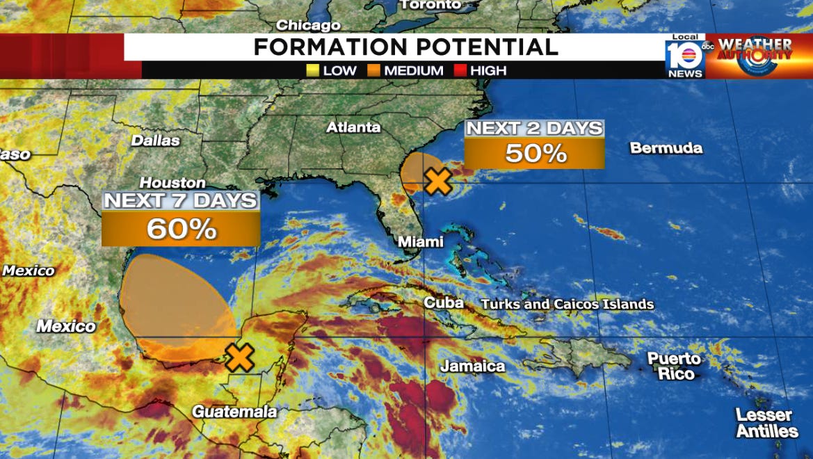
Disturbance Almost a Depression on the Doorstep of the Southeast U.S.
Small but tenacious disturbance tries to overcome the odds, but little fanfare expected as it moves inland today

The disturbance we’ve been following since this weekend took advantage of a narrow window of more conducive conditions to make a run at becoming a tropical depression on approach to the southeastern U.S. Friday morning. Hurricane Hunters are still investigating the circulation to determine if a depression has formed, but regardless the system is expected to bring only a passing presence to the coast later today.
The small but tenacious area of low pressure battled against persistent wind shear all week to capitalize on a late reprieve in hostile upper-level winds beginning Thursday. Extra ocean heat along with the nearby Gulf stream helped to ignite new thunderstorms as it approached waters off the southeast, which cinched up the surface circulation, a critical piece missing from earlier Air Force Hurricane Hunter missions. While the circulation has improved since yesterday, NHC forecasters will make the final call on whether it meets their strict criteria for a well-defined center to allow them to upgrade it to a tropical depression.
Upgrade or not, the system isn’t expected to have time to strengthen before moving inland between the First Coast of northeast Florida and Golden Isles of southeast Georgia later this evening. Many of these areas are unusually dry, so the rainfall will be largely beneficial and inland flooding isn’t a concern for now.
The low-pressure area will agitate the already rough surf and maintain the threat for dangerous rip currents along the southeast U.S. beaches, with the possibility of minor coastal flooding and beach erosion around tonight’s higher-than-normal high tide.
Another Gulf system on the way this weekend?
Tropical systems are a little like bananas – we often get them in bunches. The Atlantic is proving that this week with Alberto, the depression-like disturbance approaching the southeast, and what could become our third system following closely in Alberto’s footsteps over the southern Gulf.
Forecast models show a broad area of low-pressure coming together over the Bay of Campeche in the extreme southern Gulf this weekend. Since the system is starting large like Alberto, it isn’t expected to organize quickly, but it could consolidate into a depression or low-end tropical storm before pinwheeling into northern Mexico late Sunday into Monday.
The upshot will be additional tropical downpours, mainly into northern Mexico, where mountainous terrain on the windward side (where winds blow up the mountain slope) often enhance the flood threat.
Places like Monterrey, Mexico, in the foothills of the Sierra Madre Oriental saw widespread flooding from Alberto’s heavy rains this week and could face additional flooding in the days ahead.
Atlantic quiets down into next week
Behind the flurry of activity this week, the Atlantic looks to settle down for the near term, with no additional areas of development likely beyond the weekend.


Thanks again for your excellent explainations so we have a fair interpretation of what is happening.
As always each email is a real help and education, thank you,