Atlantic Hurricane Season Heats Up
Monitoring possible development from the Gulf of Mexico to the eastern Atlantic in the week ahead
We rarely get through August in the Atlantic without a jump in hurricane season activity, that abrupt transition which takes us from the July doldrums to the rapid pace of hurricane season’s busiest 6-week stretch. Yesterday, our forecast models seemed to make the sharp turn from the humdrum to the hectic, spinning up a dizzying array of disturbances to watch in the coming week.
As we discussed in Tuesday’s newsletter, we’re monitoring three areas for potential development – two disturbances in the east-central Atlantic this week and another by Sunday into Monday in the Gulf of Mexico.
Though farthest away in time and not the system with the greatest development odds for now – 20% over the next 7 days according to the National Hurricane Center – a low-pressure system that could form over the west-central Gulf brings the most immediate threat for U.S. impacts. The system will originate from a mixture of a tropical wave currently moving into the eastern Caribbean and the remnant spin along a washed-out cold front draped over the Gulf.
The predecessor tropical wave won’t encounter more conducive winds aloft until it moves west of the Florida peninsula on Sunday. With a massive dome of high pressure anchored over the central U.S., clockwise steering around the base of this impressive ridge will shove any developing system toward the western Gulf of Mexico. Depending on how long the disturbed weather spends over record warm Gulf waters, a tropical system could try to form before reaching the coast of Texas or northern Mexico early next week.
Though these drought-stricken areas could use a steady, soaking rain, interests here will want to monitor the forecasts for any heightened threats into next week. The system isn’t a concern for us in South Florida.
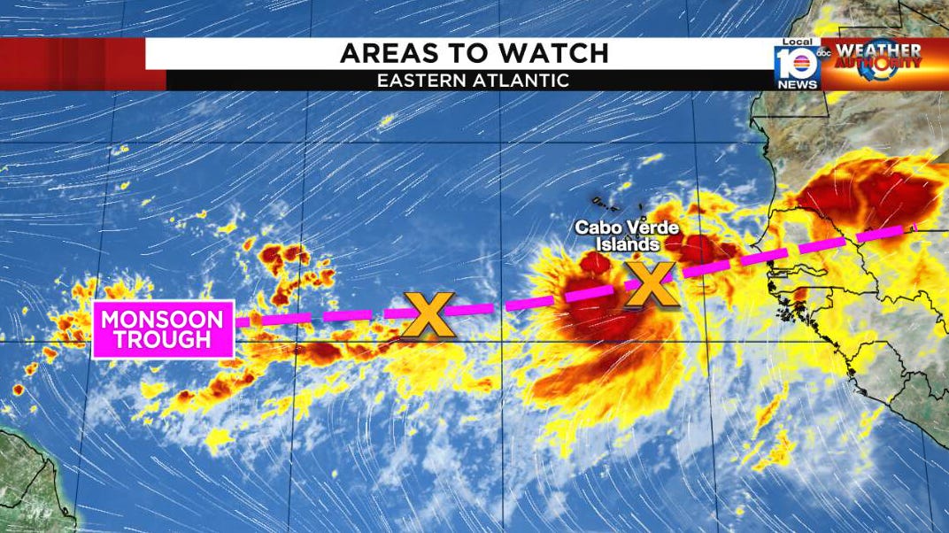
Meanwhile, we’ll be following two other disturbances in the eastern Atlantic currently situated along a semi-permanent strip of background spin and storminess known as the monsoon trough.
The National Hurricane Center gives each of these areas a medium chance of development going into the weekend. There is some disagreement in forecast models on where one or both areas may try to form along the longer umbilical cord of the monsoon trough, but in general they will be heading northwestward.
It’s worth noting that the European model follows a western lobe enhanced by a tropical wave toward the eastern Caribbean for the weekend, but for now keeps it weak.

The eastern islands of the Caribbean will want to monitor for changes in the coming days, as these features may bounce around, but for the time being none of these systems poses a significant threat to land.


Thank you for easily understood information.
Great information, as always.
Tysm 🌺