Rafael Organizing, Tropical Storm Warnings Issued for the Lower and Middle Florida Keys
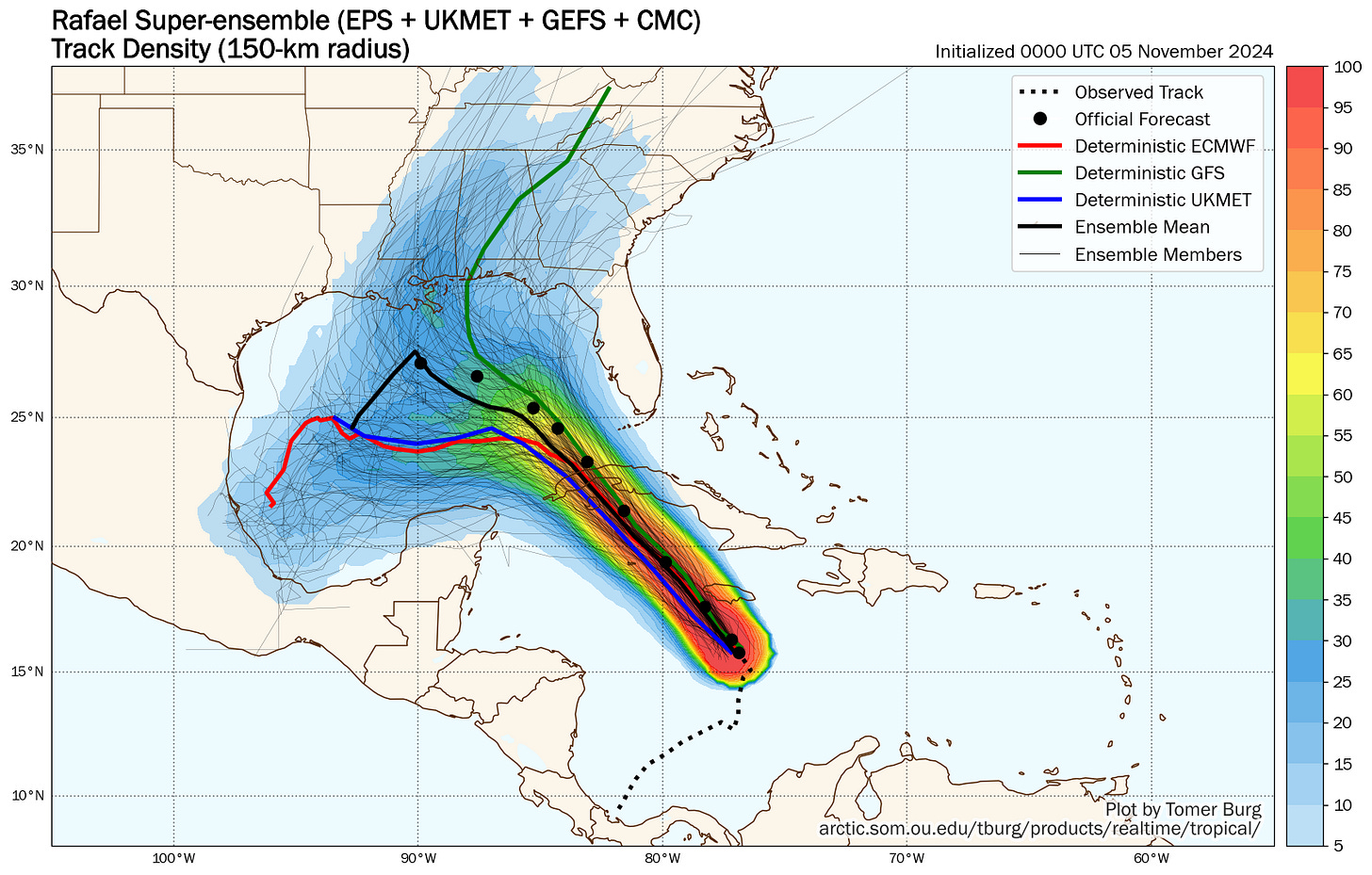
Rafael forecast to enter the Gulf of Mexico as a hurricane, but pass west of South Florida and quickly weaken before reaching the U.S.

Tropical Storm Rafael formed on Monday in the Caribbean – the 17th named storm of the busy 2024 Atlantic hurricane season – and is on track to impact the Cayman Islands later today and parts of western Cuba on Wednesday as a hurricane.
Heavy rains and tropical storm conditions are affecting Jamaica this morning, where up to 10 inches of rainfall is forecast as Rafael’s center brushes the island’s southwestern coastline.
Rafael expected to become a hurricane later today
Rafael continues to gradually organize, but conditions ahead will favor quicker strengthening and Rafael will be near or at hurricane strength by the time it blows through the Cayman Islands late this evening and during the predawn hours Wednesday.
On the current forecast, Rafael is expected to strike western Cuba as a high-end Category 1 or borderline Category 2 hurricane during the day Wednesday and emerge in the Gulf of Mexico southwest of the Florida Keys as a hurricane late tomorrow, becoming only the 5th hurricane in the modern record (since 1966) to make it into the Gulf in November.

While the core and worst of Rafael will pass southwest of the Florida Keys, it will still bring tropical storm conditions – winds above 39 mph – primarily south of Islamorada and Lower Matecumbe Key, as well as minor coastal flooding for oceanside areas of the Keys by tomorrow night.
Although the track of a hurricane into the Gulf looks menacing, Rafael’s journey may come to an abrupt end before it ever touches U.S. soil, as strong upper-level winds and dry air over the northern Gulf shut off its tropical engine by late week.
Windy South Florida and rainy southeast U.S.
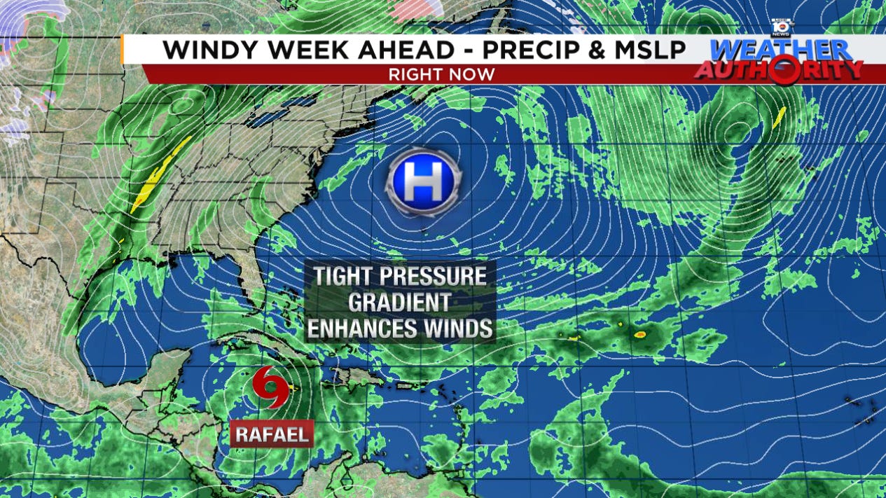
As we discussed yesterday, unusually high pressure off the eastern U.S and Rafael to the south has created a strong pressure gradient across South Florida, leading to a period of windy weather that will continue through at least Wednesday, especially for southeast Florida.
A wind advisory is in effect for coastal Miami-Dade, Broward, and Palm Beach Counties for the next few days, with gusty winds out of the east up to 40 mph possible. The windy weather should subside by Thursday and Friday.
Though rain chances will increase across South Florida the next few days with the soupier air ahead of Rafael, we’re not anticipating any widespread flood issues locally.
Farther north, however, the tropical moisture surge well ahead of Rafael could produce a flood threat across inland parts of Georgia and interior South Carolina on Wednesday. Though not technically a Predecessor Rain Event or PRE, it will have PRE-like characteristics and the recent dry spell – with many of these locations not having received measurable rain in over a month – could contribute to extra runoff and enhance the flood threat atop parched clay soils.
For now, the Weather Prediction Center is highlighting interior Georgia and South Carolina for the possibility of scattered flash flooding on Wednesday.
November guards the Gulf Coast
There’s a good reason only 4 hurricanes in 60 years have made it into the Gulf during the month of November. The Gulf isn’t a friendly place for would-be hurricanes in November and doesn’t treat them kindly when they come knocking this time of year.
Rafael isn’t a Milton or Helene scenario and, while forecast models are still divided on whether it turns northward toward the Gulf Coast or continues westward through the central Gulf, if it does move toward the U.S. shoreline later this week or this weekend, it will likely topple before ever posing much of a threat.

Those along the northern Gulf will want to keep tabs on the forecast for the possibility of lingering effects later this week, but Rafael isn’t expected to pose a significant wind threat.
Elsewhere in the Atlantic
An area of low pressure dangling from an old cold front will move westward toward the Bahamas and South Florida for this weekend. NHC is giving it only a low chance of development in the days ahead as models don’t indicate much organization.
The upshot will be an increase in rain chances for South Florida on Sunday into Monday of next week.


While that little Bahamas low has a lower chance of development than it did earlier, it's still possible the two could combine or at least Rafael COULD rob moisture from the Bahamas low before it has a chance to organize. Regardless, this little low isn't much of a threat. It could add a few extra thunderstorms to the mix.