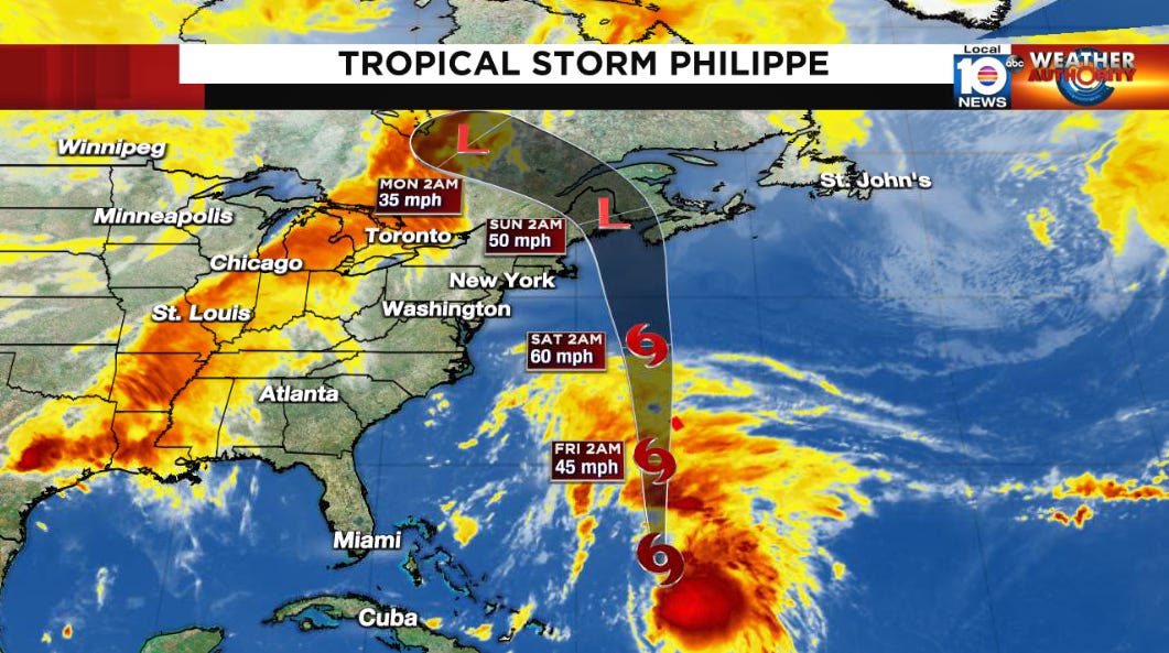
Philippe Largely Unchanged, Tropical Storm Conditions Expected in Bermuda by Tonight
Meanwhile a 213 mph surface wind gust recorded off Taiwan on Wednesday from Typhoon Koinu may challenge global wind records

Philippe continued to bring heavy rains to parts of Puerto Rico and the Virgin Islands on Wednesday, producing areas of flooding from widespread totals of 4-8 inches over the islands. The rains will continue to taper off today as Philippe finally begins to accelerate northward and away from the Caribbean.
The system effectively flatlined as a 40-50 mph tropical storm over the past 11 days, and little change in strength is anticipated for the day or two. Philippe will pass near or just west of Bermuda by Friday morning, bringing tropical storm conditions to the British Overseas Territory by as early as this evening. The main impacts to Bermuda will be the potential for isolated flash flooding from up to 5 inches of rainfall and dangerous surf conditions through the end of the week.
By the weekend, the arduous and unpredictable journey of Philippe will come to a close as the storm merges with a larger frontal low-pressure system and bends back toward Atlantic Canada and New England. Though the low pressure may strengthen over the weekend, it will do so as an extratropical cyclone. Gusty winds and heavy rainfall are likely from the combination of Philippe and the advancing frontal system from the Maine/New Hampshire border northward toward the Bay of Fundy beginning late Saturday into Sunday.
Category 4 equivalent Typhoon Koinu slams Taiwan, sets a potential surface wind record for Asia
Category 4 equivalent Typhoon Koinu moved across Orchid Island, a small volcanic island off Taiwan, Wednesday morning eastern time before slamming into southern Taiwan some hours later. A wind gauge situated high atop an observation tower at about 1,000 ft elevation measured a wind gust to 213 mph as the typhoon passed. While it seems likely that the winds were accelerated by flow around the high coastal escarpment, if confirmed, the observation would be 3rd highest surface wind speed ever recorded globally.
Mostly quiet elsewhere in the Atlantic
A tropical disturbance forecast to roll off Africa late tomorrow into Saturday has a low chance of developing by the middle of next week. The system is unlikely to make it very far if it forms and is no threat to land for now.
Elsewhere the Atlantic will stay mostly quiet, especially closer to home, into next week.


