New Area to Watch in the Atlantic for Next Week
Models suggesting the Atlantic may reopen next week after a late August lull
If you follow our daily reading of the tea leaves, you know this time of year we don’t get many lucky breaks. We’ve been given a bonus cup of calm this week, but as we previewed in last Tuesday’s newsletter, things will begin to pick up again by this weekend as the calendar turns to September.
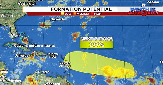
Forecast models are now showing some modest development odds associated with a disturbance rolling into the central Atlantic this weekend. As of Tuesday morning, the National Hurricane Center was giving the area a low chance of development, indicating generally favorable conditions for slow development into early next week.
The system will likely come together in part from a long strip of storminess dangling into the central Atlantic from the coast of Africa known as the monsoon trough. This collision zone of winds and airmasses is a notorious instigator of tropical saplings, but exactly where within the wider zone of storminess the system sets up is a little unclear yet.
Regardless, models show it generally moving toward the easternmost Caribbean islands for Monday into Tuesday of next week.

Interests in the Lesser Antilles, which sit at the entrance of the eastern Caribbean, should monitor the forecast trends this week.
Forecast models are all over the place on what may happen beyond early next week, so we’ll need to give this one a little time to shake out. The general flavor is the system continues moving near or north of the Greater Antilles, including Puerto Rico, the U.S. Virgin Islands, and Haiti and the Dominican Republic from next Wednesday through Friday.

This would be a familiar path taken by Ernesto most recently and the disturbance that eventually became Debby at the beginning of August.
With more than a week to go and no coherent trackable system, you can be sure much of this will change, so for now we’ll simply monitor the trends. We have plenty of time yet to follow this, even for the islands which could see some weather as it moves through early next week.
It’s almost September, the peak month of hurricane season, so be ready for a busy few weeks ahead.


Well, we will have to wait few days and see if the odds go up or down.
From what I saw last night, any system that forms seems to have an early possibility for passing just east of Bermuda, but that's in the LONG long range and we'll just have to watch and see if that holds up.