


Milton Stronger, Forecast to Strike Florida's West Coast as a Major Hurricane this Week
Significant flood threat begins today across South Florida, especially across the Miami and Fort Lauderdale metros, well ahead of Milton

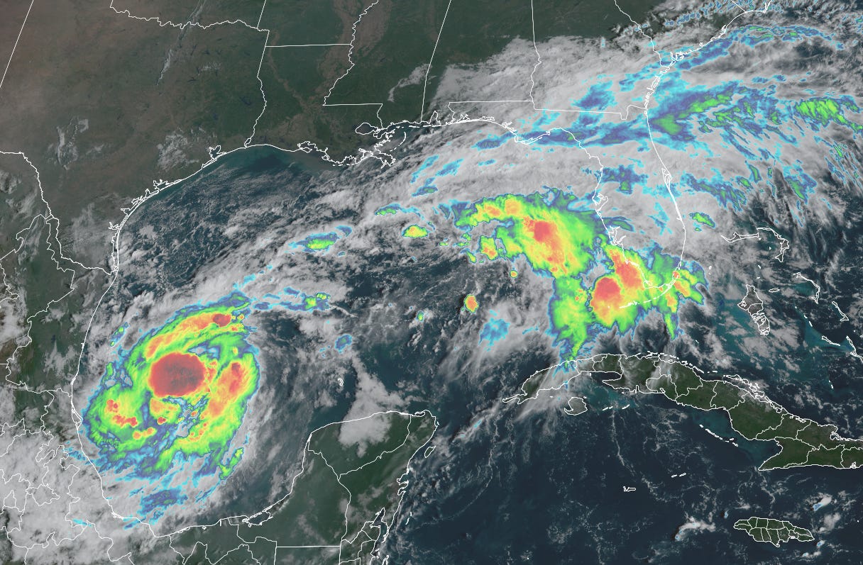
Tropical Storm Milton formed on Saturday and is forecast to strengthen into Hurricane Milton by tomorrow before accelerating toward Florida’s west coast on Tuesday into Wednesday.

The official forecast takes Milton inland as a major Category 3 hurricane, which will bring life-threatening impacts, including potentially catastrophic storm surge, to portions of Florida’s vulnerable west coast by mid week.
The National Hurricane Center is expected to issue Hurricane and Storm Surge Watches today for portions of Florida later today. Those living in low-lying areas along Florida’s Gulf Coast from Naples northward to Cedar Key, including Tampa Bay, should follow the advice of local officials as evacuation decisions are made in the coming hours.
PRE Milton rainfall brings significant flood threat to South Florida today and Monday
Parts of the Miami-Dade and Broward metro areas saw up to 3 inches of rain on Saturday, which is setting the stage for a much more widespread rain and significant flood threat beginning today.
As we previewed in newsletters last week, a series of Predecessor Rain Events or PREs are expected to set up over South Florida beginning today and on Monday, well ahead of the direct rains brought by Milton late Tuesday and on Wednesday. PREs can be especially dangerous when they occur because they quickly saturate soils in advance of the heaviest rainfall from landfalling tropical systems. The early rains can also loosen root systems, making trees more vulnerable to strong winds.

Rainfall totals today across South Florida could top 6 inches or more, especially as some of the heavier rounds of tropical downpours push through this evening. All of South Florida is under a Flood Watch through Thursday morning in anticipation of an extended period of heavy rain ahead of and associated with Milton.
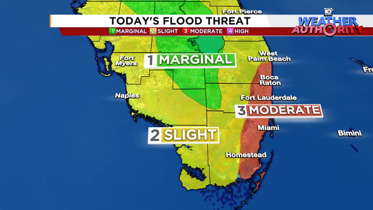
Additionally, the National Weather Service Weather Prediction Center has put coastal Miami-Dade, Broward, and Palm Beach Counties under a moderate risk for excessive rainfall today – its second highest flood category. A moderate risk indicates the likelihood of numerous flash floods, with the possibility of significant flooding, so stay aware today, especially if venturing out on roadways susceptible to flooding.
Milton’s long runway for strengthening
The first hurricane hunter flight into Milton Sunday morning found the central pressure in the storm substantially lower than estimated by the National Hurricane Center.
The already-low pressures indicate a quickly strengthening Milton, which is starting an unusual spot in the far southwestern Gulf of Mexico for what’s forecast to be a Florida hurricane hit. Only 3 named storms on record have formed this far south and west in the Gulf and gone on to strike Florida’s west coast as a hurricane.

Each of these eventual hurricanes occurred in October way back in the 19th century – 1859, 1867, and 1888 – and each struck near or north of Tampa.
This isn’t to imply the same track with Milton, but forecast models are in broad agreement with the center of Milton tracking inland somewhere between Fort Myers and Cedar Key by the middle part of the week.
What’s most concerning about the usual starting point is the longer-than-normal runway for strengthening over still very warm Gulf of Mexico waters. Milton will be passing over the notorious loop current – a ring of very deep, warm waters over the east-central Gulf – in the days ahead. This should allow for steady to rapid strengthening.

The big question is how much wind shear increases near or around the time of landfall, which could help to weaken Milton as it nears the coast. The timing on this is very uncertain, but faster-moving scenarios would give Milton less time to feel the effects of increasing upper-level winds.
Regardless, intensity guidance suggests a high-end potential for a major Category 3 or stronger Milton, which could bring devastating storm surge to some of Florida’s most storm-surge-prone and populated places.

Many of these areas at risk of potential storm surge flooding from Milton saw incredible, widespread storm surge flooding from Helene less than two weeks ago and remain extra vulnerable in its wake. Residents in low-lying areas along Florida’s west coast should be prepared to evacuate ahead of Milton if asked to do so.
Kirk and Leslie over the open seas
Meanwhile Hurricanes Kirk and Leslie continue to churn over the open Atlantic.

Kirk will be weakening over the next few days as it accelerates northeastward toward Europe as an extratropical storm.
Leslie should hit its peak over the next 12 to 24 hours and isn’t expected to pose any threat to land.
Thank you for the info Mr. Lowry. It is very much appreciated even if the information itself I wish was different. Not happy to see my area closer to the center of the cone than it was. Oh well, one has to deal with reality.