Major Hurricane Beryl Blowing by the Caymans on Course to the Yucatán
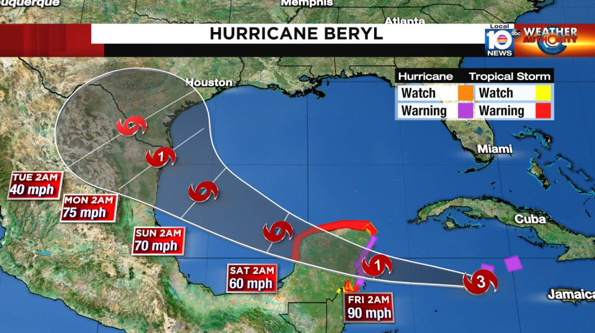
Beryl forecast to threaten northern Mexico or South Texas by late weekend as a weaker hurricane
On Wednesday, the eye of a resilient Category 4 Hurricane Beryl passed to within about 15 miles of Jamaica’s southwestern shoreline, scraping the southern parish of St. Elizabeth and town of Treasure Beach with its northern eyewall and delivering Jamaica its nearest major hurricane pass since Gilbert raked over the island in September 1988.
Hurricane Hunters investigating Beryl up until landfall and high resolution wind estimates from satellite-based instruments around Beryl’s final approach to Jamaica found the extent of Beryl’s strongest winds to be fairly small.

Its hurricane force winds only extended out about 40 to 50 miles from its center, with its devastating Category 4 winds contained to about 10 to 12 miles to the north of its eye. Kingston – Jamaica’s most populated city – remained just outside Beryl’s sustained hurricane force wind field, though wind gusts up to 81 mph (just above hurricane force) were reported at Norman Manley International Airport just south of the island and Kingston on Wednesday afternoon.
Beryl’s impressive run as a Category 4 or 5 hurricane
Despite most reliable guidance indicating a noticeable weakening on approach to Jamaica, Beryl continued to overachieve as a Category 4 hurricane Wednesday afternoon. By Thursday morning, a combination of land interaction with Jamaica and building wind shear had slowly eaten away at its core, and for the first time since Monday morning, Beryl’s winds fell below Category 4 strength.
Beryl first became a Category 4 hurricane on Sunday afternoon and, with the exception of a temporary 6-hour fall back to Category 3 strength early Monday, remained a Category 4 of 5 hurricane for more than 84 consecutive hours. This is an impressive stretch for any hurricane at any time of the hurricane season. Only 11 hurricanes in the satellite era (since 1966) have achieved such a prolonged period of Category 4 or 5 winds, and 10 of the 11 hurricanes did so in September or October, with none happening before August.
Mexico and South Texas in Beryl’s crosshairs this weekend
Beryl is finally on a weakening trend, albeit a gradual one, courtesy of increasing wind shear. The major hurricane was passing just south of the Grand Cayman Thursday morning and is charting a course toward Mexico’s Yucatán Peninsula, where it’s set to come ashore as a Category 1 or 2 hurricane early Friday.

Beryl’s expected to emerge over the southwestern Gulf of Mexico late Friday or overnight Saturday as a weakened tropical storm. It’ll have a day and change over the Gulf to restrengthen at it rounds the western periphery of the subtropical ridge toward northern Mexico or South Texas.
Intensity guidance indicates only modest restrengthening for now, but with some real estate over warm waters and light wind shear, it should have time to regain hurricane strength before coming ashore late Sunday or early Monday.
Those with interests in South Texas from Corpus Christi southward to Brownsville – especially along Padre Island and at the coast – will want to check back on the forecasts today and tomorrow. With the Fourth of July holiday stretching into the upcoming weekend, vacationers and beachgoers will want to stay especially aware of the forecasts for Beryl.
Regardless, dangerous surf and life-threatening rip currents will be a big threat for local beaches as Beryl churns into the Gulf this weekend.
Invest 96L blows through the Lesser Antilles but development odds stay low
The strong tropical wave we’ve been following behind Beryl – Invest 96L – blew through the Lesser Antilles Wednesday morning, bringing tropical squalls and wind gusts to nearly 60 mph to St. Lucia and Barbados.
The vigorous disturbance is playing catchup to Beryl, racing south of Puerto Rico and Hispaniola today. Development is unlikely as it moves deeper into the Caribbean and the outflow from Beryl ahead will likely stifle development odds as it moves into the southern Gulf for the start of next week.
Regardless the system will track well south and west of Florida for next week.


