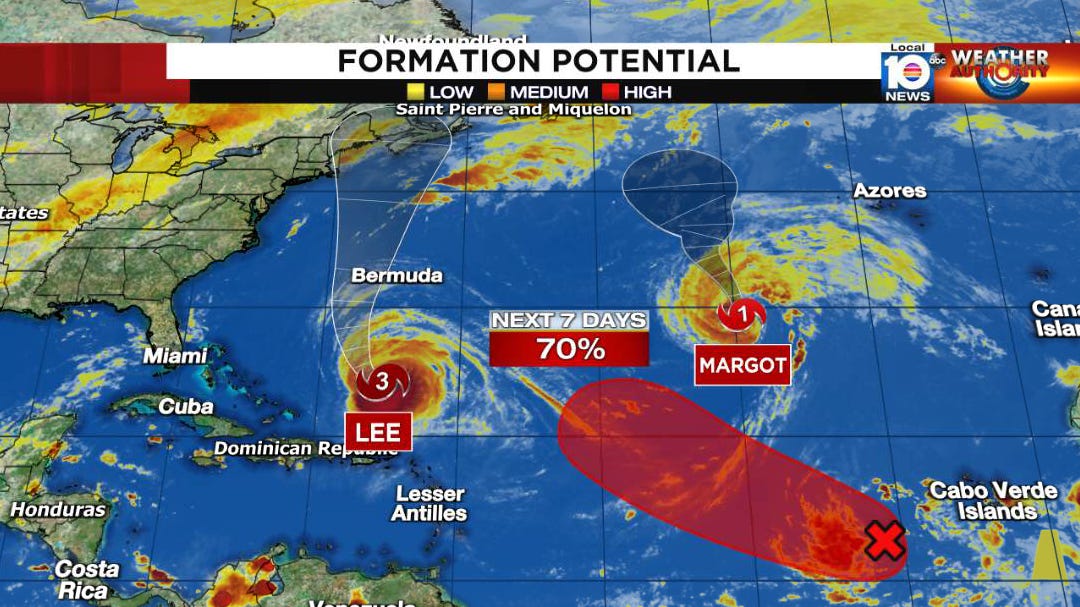
Lee Scours out a New Eye, May Bring a Close Brush to Bermuda and New England
Lee doubles in size without weakening, increasing the threat for dangerous seas, battering surf, and life-threatening rip currents along the U.S. Eastern Seaboard this week
While Hurricane Lee didn’t strengthen on Monday, it still managed to up the ante – doubling in size by one measure while maintaining its peak winds. All else equal, the developments increase the hurricane’s destructive potential and ability to generate long-period waves and dangerous marine conditions that will affect the entire Eastern Seaboard this week.
Lee is forecast to track west of Bermuda, but due to its large size is still expected to bring the threat of tropical storm conditions by Thursday into Friday. Over the weekend, the hurricane will accelerate to the waters off New England – albeit as a less intense but still potent storm – where it may get close enough to directly affect the U.S. coast from Massachusetts to Maine.
A different-looking Lee
On Monday, Hurricane Lee underwent another eyewall replacement cycle – a structural change whereby a fresh, outer eyewall forms and slowly starves the inner eyewall of its vital inflow.

The result is usually a period of stagnation or weakening, as the inner eyewall collapses and the new outer eyewall takes over. Lee did just this but without weakening, and by sundown Monday the new ring of intense thunderstorms surrounding the eye was 2-3 times larger than the previous eyewall.
The result was no less weak Lee and bigger menace. The much wider wind field increases the fetch – the distance over which the winds blow – generating bigger waves that will be propagating outward toward the U.S. East Coast this week. While the details of Lee’s ultimate impact on the U.S. are still to be determined, we know the long-period swell will create dangerous beach and boating conditions up and down the Eastern Seaboard this week.
This week isn’t the week to venture into what will be an angry Atlantic.
Lee’s close call with New England
After sliding past Bermuda later this week, Lee will pass a cool(er) patch of water left behind in the wake of Hurricanes Franklin and Idalia from the past few weeks. This, along with an increase in wind shear and dry air, will weaken Lee to a borderline hurricane, but its large footprint will continue to present a serious threat.
There remains notable disagreement among models in how close Lee will get to coastal New England by this weekend. The European model moves Lee stubbornly slow and hugs the Massachusetts Cape with dangerous winds and waves on Saturday before moving the storm inland over coastal Maine. Meanwhile, the American GFS predicts a faster Lee that instead stays farther offshore and reaches Nova Scotia by Saturday.

These forecast differences do illustrate the importance of timing on New England – a slower track would favor a closer coastal New England encounter than a faster storm accelerating toward the Canadian Maritimes.
Water, water everywhere
One of the primary concerns with any direct brush with New England from Lee are the very saturated grounds in the area. Large swaths of Connecticut to Maine have recorded some of their wettest summers on record. This year the Boston area has observed its wettest 3-month period to-date in its 152-year period of record.

The saturated soil and still-dense early fall foliage are especially problematic for a high-wind event laced with driving rains – a departure from traditional wintertime nor’easters. For now at least, a more likely outcome is a storm system staying far enough offshore to spare coastal New England a direct blow, but with 4 days to go it’s too soon to rule out something closer. Regardless, battering waves, some coastal flooding, dangerous rip currents, and shoreline erosion will accompany Lee, even with an offshore track.
The bottom line
Lee is a much larger hurricane than only 24 hours ago. Though some strengthening is possible today, Lee will be on a weakening trend as it tracks west of Bermuda later this week and toward the waters off New England by the weekend. Nevertheless, Lee’s large and potent wind field will generate swell well away from the center, creating hazardous rip currents and dangerous surf along the U.S. East Coast this week. Interests in New England should follow the changing forecasts closely over the next few days, as a slight shift west could bring more damaging conditions to the coast.
Margot becomes the 5th hurricane in a busy Atlantic hurricane season
On Monday Margot strengthened into a hurricane over the east-central Atlantic. The hurricane continues to strengthen and is expected to reach Category 2 status by early Wednesday as it stays over the open Atlantic. Though Margot is no threat to land, it punctuates a busy season at its peak – the busiest Atlantic hurricane season so far since the hyperactive 2017 hurricane season.
Eastern Atlantic disturbance poised to develop
The tropical wave we mentioned in Monday’s newsletter will be combining with a broad area of low pressure this week and another tropical depression or storm is expected to form by the weekend. While it may gain some latitude in the days ahead, it won’t immediately turn out, so we’ll keep an eye on it. The system poses no threat to land this week.


I hope Lee swings out away from New England, they sure don't need a blow from him. I really hope that new one just off Cabo Verde remains a fish storm.
What is the current total expected rainfall for central RI (Cranston-Warwick)? Thanks!