


Innocuous Subtropical Atlantic Systems in an Otherwise Quiet Week
Two systems being highlighted by NHC pose no serious threats this week

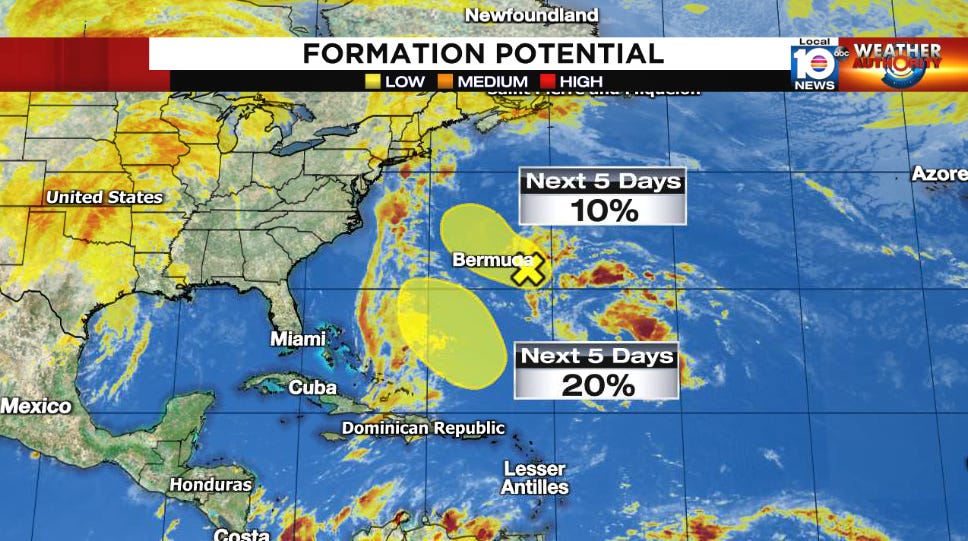
Two areas are being highlighted by the National Hurricane Center this morning for low development odds in the subtropical Atlantic – the waters directly north of the warmer tropical belt – but neither presents any concern in the week ahead.
The first area we’ve been following some 150 miles east of Bermuda – dubbed Invest 94L – has been battling persistently strong upper-level winds from the southwest. Thunderstorm activity is more concentrated this morning, but an ice bath lies ahead as it progresses northwestward and water temperatures plummet into the 50s by mid-week, quickly ending any possibility of development.
Meanwhile forecast models show an area of low pressure forming north of the Bahamas later this week. The system will be largely supported by strong south-to-north flowing jet stream winds, as winds high up fan out and encourage thunderstorm growth. Convection in purely tropical systems is fueled primarily by the warm sea surface, so anything that forms here will be subtropical in nature, with strong upper-level acting like bellows to a flame. Regardless of formation, the system will drift over the open waters of the western Atlantic into the weekend and poses no threat to land.
Otherwise, things are looking generally quiet through the week across the Atlantic.