Hurricane Season Peak is Here, but Atlantic Unusually Quiet
Earl is transitioning into a large extratropical system in the north Atlantic while we await a new disturbance expected to roll off Africa early next week
Earl is wrapping up its over two-week journey from the tropical waters off Africa to the cooler waters of the north Atlantic, while the only other disturbance worth mentioning at the typical inflection point of the 183-day long Atlantic hurricane season is one that hasn’t even rolled off Africa.
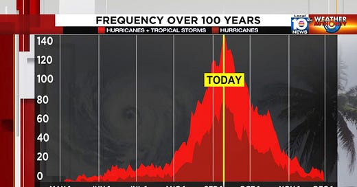
Based on the historical hurricane record that extends back to 1851, the frequency of named storms in the Atlantic is highest on or around September 10th. On average, about half of hurricane season activity occurs in the 14 weeks leading up to today and roughly half occurs in the 7 weeks following, with some 95 percent of typical seasonal activity taking place by the end of October. So while it’s unusually quiet today, the season is far from over, especially for us in South Florida, where the odds of a hurricane strike are highest in October. It only takes one particularly bad hurricane to reverse feelings of a quiet season.
That said, it’s a real comfort to look out across the Atlantic on the peak of the hurricane season and see only one named storm – in this case Earl – transitioning into a large non-tropical weather system while recurving into the open north Atlantic. Earl crept through the basin these past several weeks, drawing the wary gaze of South Floridians and Bahamians at times, but avoiding direct entanglements with land and peaking in recent days as a Category 2 hurricane while it raced north and east of Bermuda. So far, no Category 3 or stronger storms have been observed in the Atlantic, the first time that’s happened this deep into the season since 2014.
Across the deeper tropics today, the two disturbances we had been tracking between Africa and the Caribbean went largely belly up – Invest 95L getting shredded apart and accelerating northward ahead of a nearby jet stream dip and another disturbance closer to Africa lost to relentless dry and sinking air. Another disturbance is set to roll off Africa by early next week but for now none of our forecast models are especially bullish on its future.


