


Hurricane Fiona Consumes Puerto Rico with Catastrophic Flooding
Another 4-8 inches of rainfall is forecast for today across parts of the island


Nearly five years to the day that Category 4 Hurricane Maria devastated Puerto Rico, Category 1 Hurricane Fiona consumed the U.S. island territory with catastrophic flooding, with rainfall surpassing over two feet and flash flood warnings at times enveloping practically all municipalities, while plunging the entire island into intermittent darkness.


Engorged streams turned into raging rivers that tore bridges from their abutments and dangerous and destructive mudslides and rockslides piled into mountainside homes.

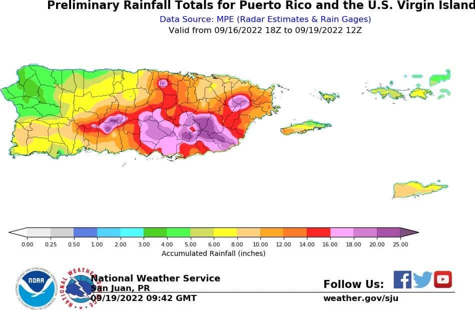
According to the National Weather Service, as of this morning upwards of 27 inches of rain has fallen over the past several days in association with Fiona, with a widespread swath of 15 to 20 inches along the south-central and southeastern portions of the island from Ponce along the southern coast to Caguas and Juncos in the east-central mountains. Another 4 to 8 inches is possible today with trailing feeder bands to the east of Fiona’s center.
Fiona’s center came ashore along the southwestern coast of Puerto Rico on Sunday at 3:20 PM AST (ET) with maximum sustained surface winds of 85 mph. Winds gusted as high as 103 mph at the Ponce Yacht and Fishing Club (El Club Náutico de Ponce) on the coast at Isla de Gata south of Ponce shortly before 2 PM AST yesterday. About 20 miles east-northeast of where Fiona came ashore, winds gusted to 113 mph inland at higher elevations (winds typically increase in elevation up to about 1,600 feet with hurricanes) at Yauco in southwestern Puerto Rico.
Last night, Fiona jogged westward through the Mona Passage as it strengthened to a 90 mph hurricane before making a second landfall about 20 miles south-southwest of Punta Cana before daybreak this morning in the Dominican Republic. The eastern portion of the Dominican Republic will feel the worst of Fiona’s winds today as the center reemerges back over water in the coming hours.

Fiona is forecast to strengthen further and impact the Turks and Caicos by tomorrow as a Category 2 hurricane. Preparations here should be rushed to completion.
The storm will get pulled northward and away from the mainland U.S. this week. Once again, Bermuda finds itself in the cone of a strengthening hurricane for later this week for what’s forecast to become the first Category 3 hurricane of the 2022 Atlantic hurricane season.

Elsewhere in the Atlantic, things will be mostly quiet this week. Models suggest we may need to monitor a tropical wave that’ll be entering the eastern Caribbean toward the end of the week, but environmental conditions likely won’t become more conducive for development until the weekend.

It is surprising that Fiona remained so much intact, and this thing was well inland at one point; usually such storms are torn apart by interaction with land and the mountains and being away from the moisture source. Not this time. Maybe there was a bit of a "brown ocean effect" possibly? Or was it the lack of wind shear and maybe something in the upper air that may have given it a bit of a boost?