Formidable Fiona Strengthens, Closely Monitoring a New Atlantic Disturbance
All eyes turn to the Caribbean by this weekend
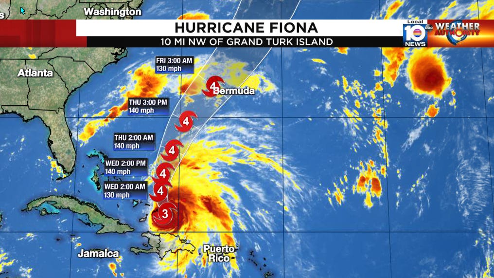
Hurricane Fiona was unencumbered after clipping the eastern shores of the Dominican Republic yesterday morning, and steadily strengthened into the Atlantic’s first Category 3 hurricane of 2022 overnight. Fiona is centered near Grand Turk this morning, with its western edge lashing the broader Turks and Caicos archipelago, and, by the end of the workweek, Fiona is forecast to threaten Bermuda as a large and powerful hurricane. The storm will remain well east of South Florida and the mainland United States.
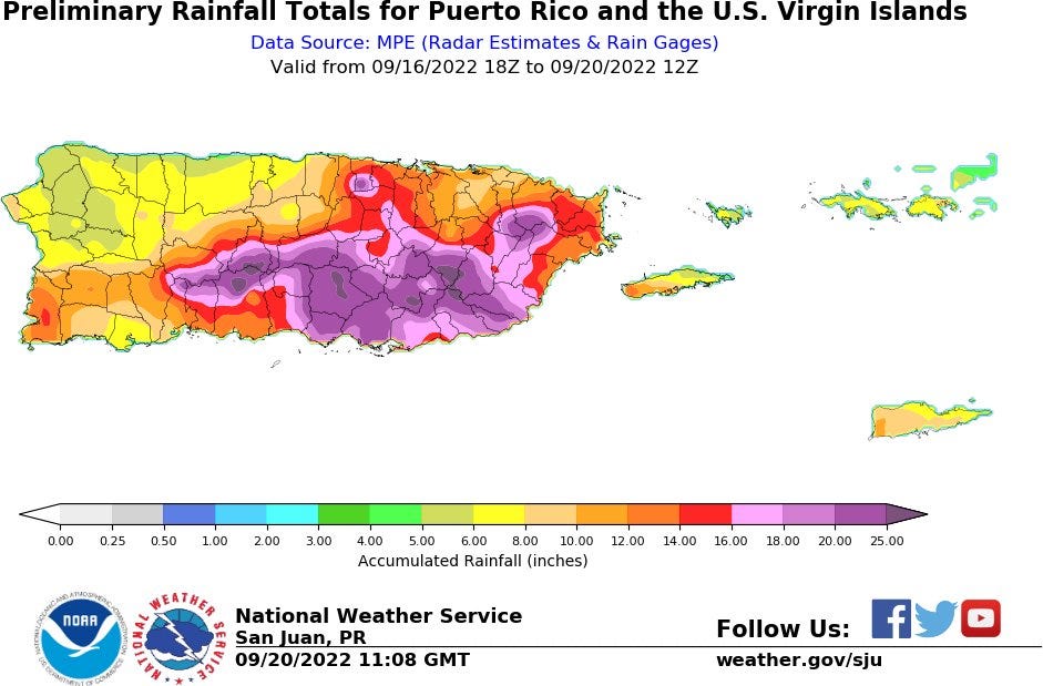
Fiona’s outer bands continued to pour out across flood-ravaged Puerto Rico yesterday, with a long fetch of winds aimed from the south lifting copious tropical moisture up the slopes of the island’s central mountains, enhancing already relentless rainfall. As of this morning, over 30 inches of rain has been measured in parts of Puerto Rico, with a wide swath of 20 inches or more.
While Fiona’s storm total rainfall may not exceed the tropical cyclone record of 41.7 inches from a tropical depression in October 1970, the ferocity of the rain that occurred could topple a 24-hour rainfall record for the island that extends back to 1985. A maximum of 38 inches of rain fell in Puerto Rico during Hurricane Maria almost five years ago to the day from September 19-21, 2017.
Fiona is a small hurricane, with its strongest winds extending out only about 10 miles from its center and hurricane force winds only about 30 miles. Its proximity to the Turks and Caicos, however, will keep the British Overseas Territory in the worst of its weather through the morning, which includes a dangerous storm surge of up to eight feet in low-lying areas. Hurricane hunters this morning indicate its eyewall is partially open to the south and southeast, indicating it may have been temporarily staved off from further strengthening by moderate wind shear.
The pause in strengthening will likely be short-lived as Fiona continues northward tomorrow and Thursday over the warm waters of the western Atlantic, where it’s forecast to become a Category 4 hurricane, with its growing wind field potentially posing a direct threat to Bermuda by the end of the week.
Aside from Fiona, our eyes will be turning to a vigorous tropical wave that by Thursday and Friday will be moving into the eastern Caribbean. Computer models indicate a ripe environment ahead of this one, especially as it reaches the central and western Caribbean late this weekend into early next week. While the disturbance or what comes of it should stay south of those areas most recently impacted by Fiona, including Puerto Rico, the southern trajectory means we’ll need to follow its progress closely in the week ahead. For now, it’s too soon to say much more, but check back in the coming days for updates.
Elsewhere in the Atlantic, an area of low pressure located in the middle part of the north Atlantic has a high chance of development but is headed northward and is no threat to land.


The low pressure in the Atlantic may simply develop, get another name out of the way. Fiona will likely be a storm that, the name will likely get retired. It is already a damaging, historic storm. Any direct hit at Bermuda will only cause much more damage; but Bermuda will quickly recover, as they know what to do during and after storms. Still, I wouldn't go tour Bermuda for a couple weeks after a powerful hurricane at Bermuda. At one point, all the power was out at Puerto Rico. Hopefully, that's why the radar went down.