


Fiona Forms, Tropical Storm Conditions Expected in the Lesser Antilles this Weekend
Hurricane Hunters begin investigating the storm today

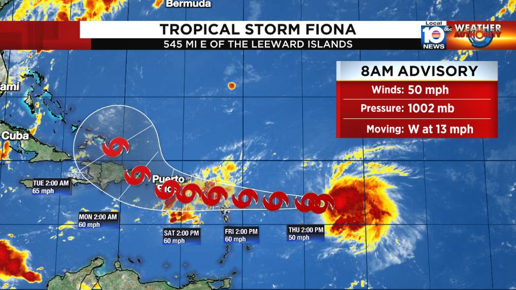
The strong tropical wave moving through the central Atlantic – formerly Invest 96L – continued to organize yesterday, becoming Tropical Depression Seven by late morning and strengthening to Tropical Storm Fiona by evening, and is expected to bring gusty winds above 40 mph, heavy rains, and the potential for floods and mudslides to the northern Lesser Antilles, Puerto Rico, the Dominican Republic, and Haiti by this weekend into early next week.
Fiona continues to battle modest wind shear this morning, which is largely keeping the system in check as a 50 mph tropical storm. Its low-level center is riding out ahead of the big, comma-shaped canopy of showers and thunderstorms trailing it. With its mid-level circulation embedded in the plume of thunderstorms east of the true, low-level storm center, any additional strengthening today will be gradual. Intensity guidance suggests modest westerly to northwesterly shear will continue through the week and with potential speed bumps of land ahead, the forecast maintains Fiona as a tropical storm along its track through the islands of the northern Caribbean.
The steering directing Fiona, at least in the near term, is relatively straightforward. Clockwise flow around high pressure to the north will guide the storm toward the west into the weekend, with some differences in how quickly the storm reaches the islands.

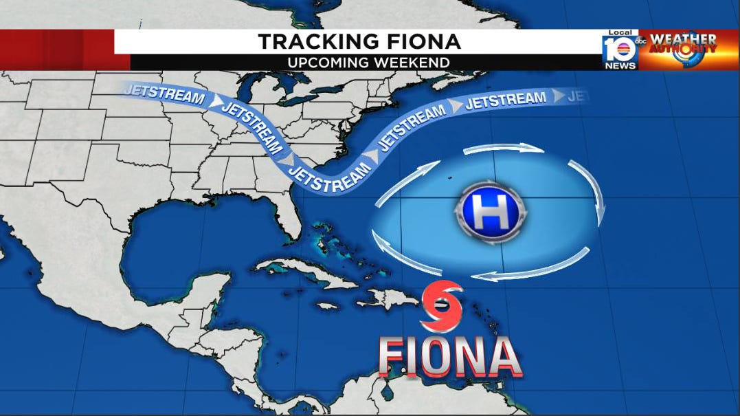
By late weekend into early next week, a dip in the jet stream along the U.S. east coast will carve a path to allow Fiona to bend northward.
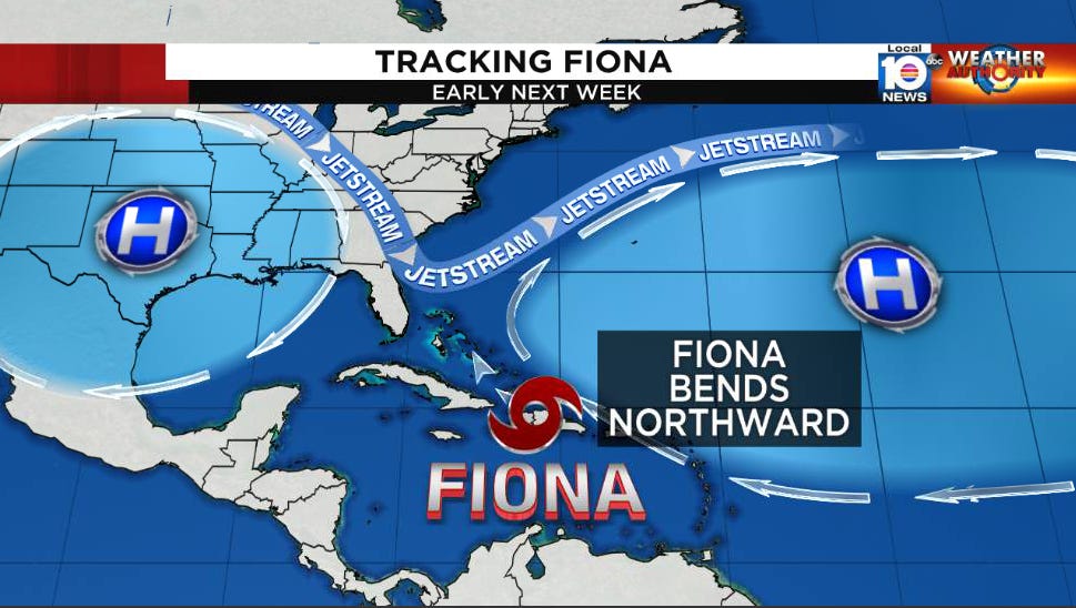
While there remains a wide range on when this happens (before, after, or around Hispaniola), the consensus of forecast models shows this bend by early next week. As is typically the case with tropical cyclones, a weaker system would favor a more westward track and a stronger system feeling a bigger tug northward.
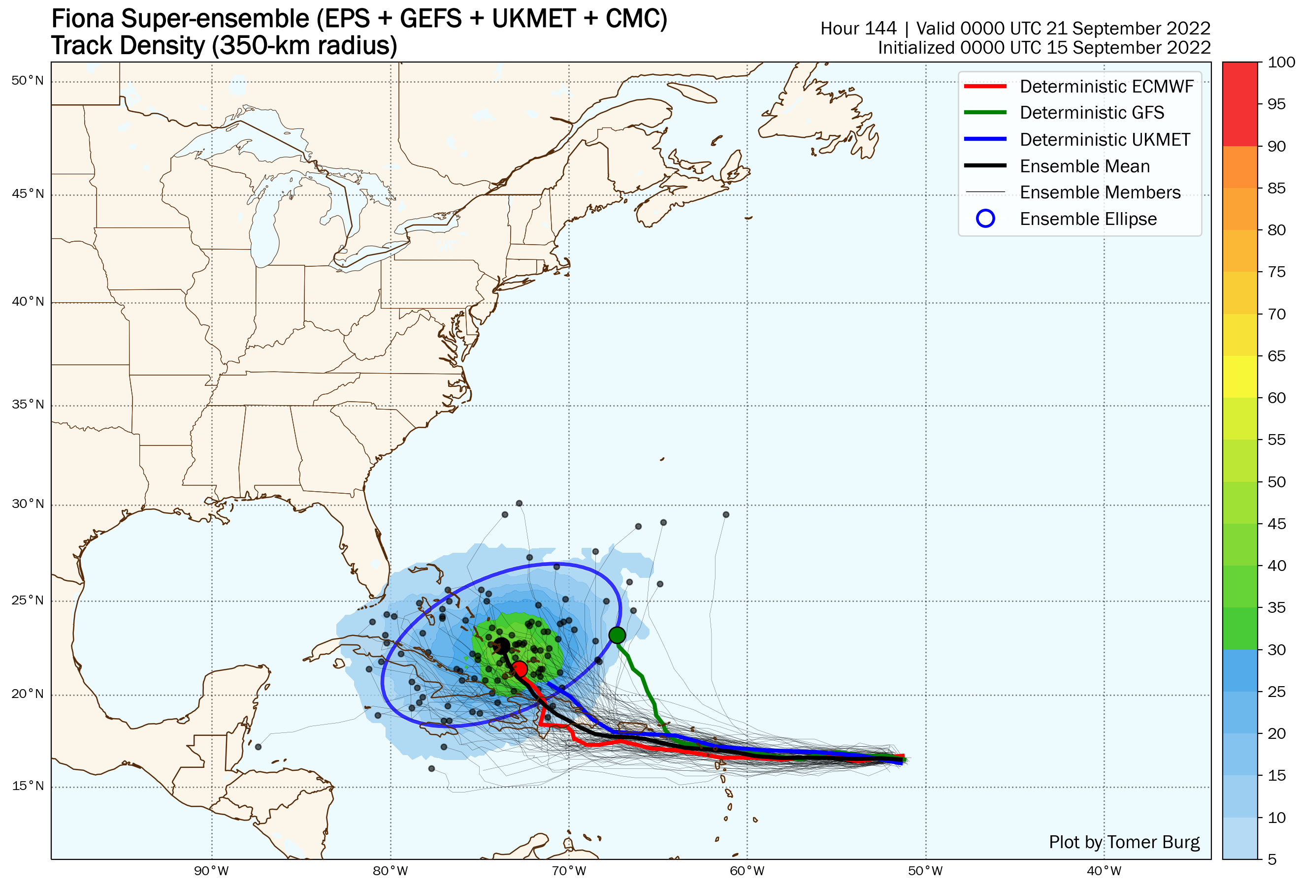
Of course, all of this assumes no major center relocations if the low-level circulation bleeds eastward under the heating of the mid-level circulation. With land interaction ahead and an unusually complicated upper-air pattern, it’s going to take a few days to sort through all of the long-range details.
The bottom line for South Florida is stay informed of the evolving forecasts. It’s far too early to dismiss Fiona, but there are some things working in our favor right now.
In the meantime, heavy rainfall atop already saturated soil and squally weather are a concern in the coming days for our friends from Antigua and Barbuda to Puerto Rico and the Virgin Islands. The Bahamas and Turks and Caicos should continue to monitor Fiona’s progress into the weekend.
For us in South Florida, check back for updates. We have Hurricane Hunter missions beginning today and expect high-altitude aircraft missions soon that will hopefully help us gain clarity of the potential threats beyond this weekend.
Laura T. I see you liked the article, so you are aware of the newest tropical storm. The good news is I don't see it becoming a hurricane; and I don't see it going to Florida at this time. As Mike says, stay alert. Stay tuned just in case these models trend hard westerly and it makes any path to Florida. otherwise, expect the usual showers and thunderstorms, the regular daily summer storms, Laura.