Coastal Conditions Deteriorate Today Ahead of a Strengthening Nicole
Storm Surge Warnings posted for Florida's entire Atlantic coast north of Broward County

Storm surge warnings were issued late Monday for Florida’s entire Atlantic coastline from North Palm Beach northward and for parts of southeast Georgia in anticipation of widespread coastal flooding from Nicole’s expansive circulation. Coastal conditions will deteriorate today and worsen especially on Wednesday as Nicole draws near to the Florida coast. While the most significant coastal impacts will be north of Broward County, minor to moderate coastal flooding, dangerous surf, and beach erosion will impact the coastline south to Miami-Dade as large waves break atop some of the highest tides of the year.
Nicole formally transitioned from a hybrid to a fully tropical storm this morning. Its organization has improved since yesterday, with a more concentrated area of storminess near its center, signaling a period of strengthening that should continue until landfall late Wednesday or during the pre-dawn hours Thursday. Pressures are steadily falling this morning according to Hurricane Hunters flying inside the storm and maximum winds near the circulation center will gradually increase today.
Even with Nicole shedding its subtropical designation, its wind field will remain large, especially north of the center, where tropical storm winds are forecast over 350 miles to its northeast around the time of landfall in Florida. Because of this, the coastal impacts won’t be limited to the landfall area as with most tropical storms and hurricanes, and nor’easter-like conditions will be felt along along a long stretch of the southeast U.S. coastline. The breadth of Nicole’s tropical storm winds are remarkable, with less than two percent of all tropical or subtropical cyclone “fixes” since 2004 showing such a large wind field.
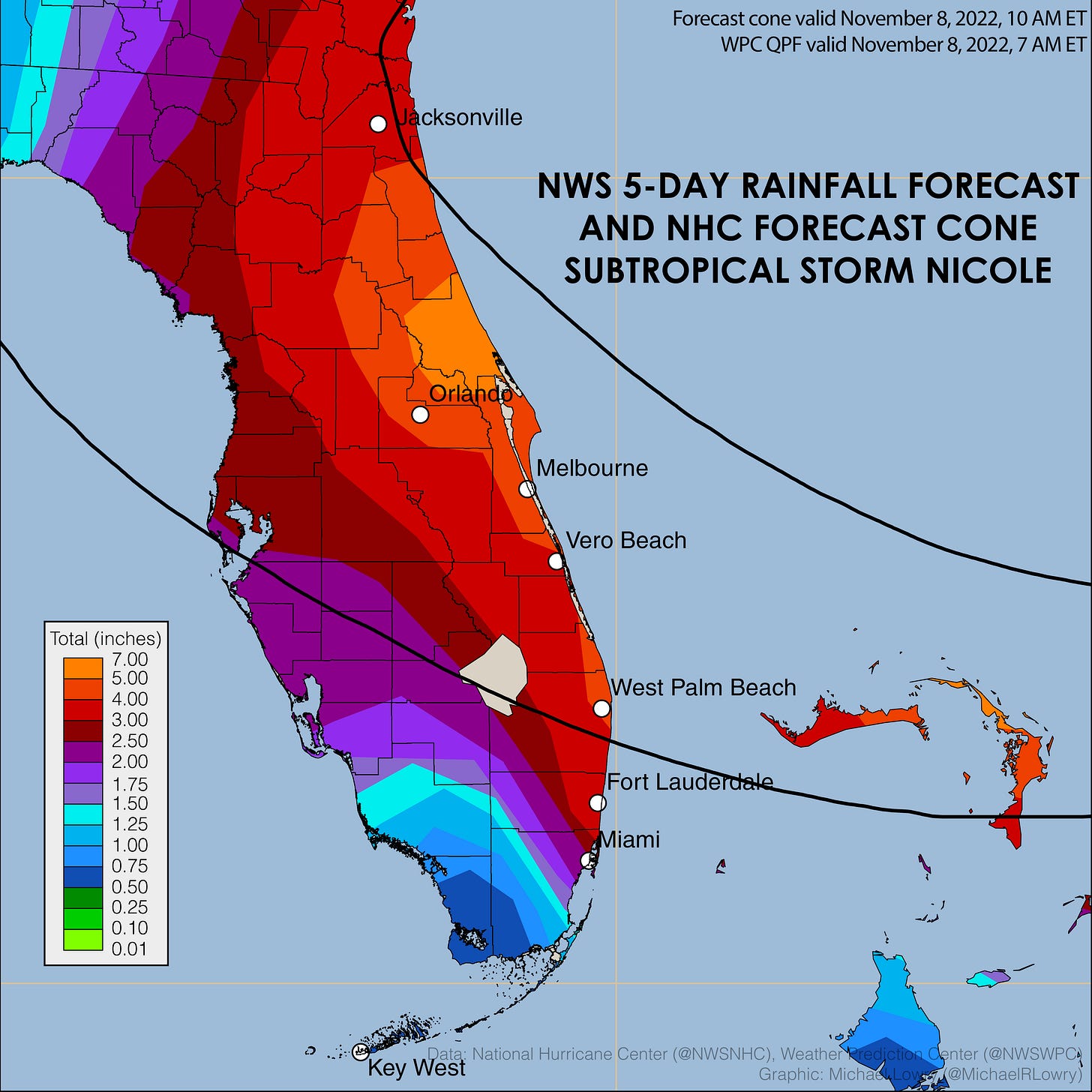
Forecast models are in good agreement with Nicole’s track toward Florida, with landfall most likely from Palm Beach County to the Space Coast. While periodic squally rain showers will begin moving through Miami-Dade and Broward Counties later today and increase through tomorrow, the lopsidedness to the weather and forecast track north of our area will keep the sharp gradient of heavy rain primarily to our north. We’ll need to watch for any training of showers in outer bands, but the biggest coverage of heavy rain will be across north and central Florida, with concerns especially in river basins still dealing with lingering flooding and saturated grounds from Ian last month.
Nicole is forecast to be a hurricane by the time it reaches Florida’s coast late Wednesday. While historically rare for November – Nicole would be only the second hurricane on record to strike the Florida peninsula in November, the first in 87 years, and the latest recorded hurricane to strike the peninsula – intensity guidance doesn’t show strengthening beyond a borderline Category 1 hurricane. Unlike the storms of August, September, and October, rapid strengthening isn’t in the cards for Nicole.
The wide, sweeping nature of its winds and rainfall will be Nicole’s calling card in the days ahead. The storm will quicken its stride by Thursday, bending and accelerating northeastward as conditions improve across South Florida. Over the weekend, a cold front will clear the Keys, ushering a return to our normally scheduled dry season programming and hopefully an end – once and for all – to our hurricane season.


We interrupt this regularly scheduled dry season program to bring you this special tropical storm report. Nicole heading toward Florida!! There will be more bulletins over the next 2 days or so, till it is done in Florida. Then, we will return to our regular dry season program!! Laura T., did you read this article? The good news, there will be no impact on Election Day. Voting was going ahead as planned. Hopefully, Punta Gorda does not get too much steady rain & wind.