Atlantic Sees Historic Tropical Cyclone Outbreak, Hilary Hits Southern California with Devastating Floods
Three named storms since Saturday have formed in the Atlantic, but none poses a threat to Florida

As we discussed in our August 1st newsletter, myriad factors appeared to favor activity for the latter part of August. This weekend, the Atlantic delivered in spectacular fashion, with three tropical cyclones forming – Tropical Depression Six (now Gert), Tropical Storm Emily, and Tropical Storm Franklin – in only 24 hours, only the third time that’s occurred since records began in 1851. The historic outbreak of tropical cyclones in the Atlantic was echoed in the eastern Pacific by the historic hit from Hilary in Southern California on Sunday, only the third known tropical storm or hurricane to cross fully into California and the state’s strongest tropical storm since 1939.
Let’s start with the most immediate threats in the Atlantic.
Potential Tropical Cyclone Nine (Gulf of Mexico) and Tropical Storm Franklin (Caribbean)
For this week, the only system expected to have any impact to the mainland U.S. is recently designated Potential Tropical Cyclone Nine (formerly Invest 91L) over the Gulf of Mexico. Organization has gradually improved and the National Hurricane Center designated it a potential tropical cyclone late Monday morning, indicating their expectation it will become Tropical Storm Harold before moving inland over South Texas early Tuesday.
Although tropical storm warnings have been issued for parts of South Texas to just north of Corpus Christi, the potential tropical cyclone will have limited time to strengthen before moving inland. The most likely outcome will be beneficial rains and a brief reprieve to relentless heat for parts of south Texas.
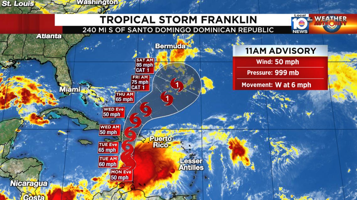
Farther east over the central Caribbean, Tropical Storm Franklin will bring the threat for flooding rains from Puerto Rico to the Dominican Republic and Haiti through mid-week. Up to 6 inches of locally heavy rain is forecast in Puerto Rico and locally up to 15 inches across Haiti and the Dominican Republic, which could lead to life-threatening flash floods and mudslides.
The storm won’t make it much farther west than it is now as it’s slingshot northward by a series of jet stream dips. While Franklin poses no threat to Florida or the mainland U.S., interests in Bermuda will want to monitor this week as forecasts show the potential for strengthening as it accelerates northward by late weekend.
Tropical Storms Emily and Gert: Lost at Sea
The first named storm to form this weekend was Tropical Storm Emily over the central Atlantic. It was preceded by Tropical Depression Six – now Tropical Storm Gert – northeast of the eastern Caribbean islands. Emily has lost all associated storminess and will move harmlessly out to sea while short-lived Gert is already in the process of unraveling. Neither system poses any threat to land.
Invest 92L (Eastern Atlantic) and Looking Ahead
Farthest east near the Cabo Verde Islands of Africa, another strong tropical wave – designated Invest 92L – shows promise of slow development this week. Though still early, 92L should lift far enough north this week to not pose an issue down the road to the Caribbean islands.

As we head into next week (August 27th), we’ll want to keep our eyes to the area around Central America. While there’s nothing solid yet in the models, guidance indicates a broad gyre setting up from which a defined area of low pressure could try to form in the western Caribbean or southern Gulf of Mexico. We’ll revisit this area as we get a clearer picture this week.
Hilary Crosses into California, Breaks Records
Once-Hurricane Hilary crossed into California Sunday afternoon as a full-fledged tropical storm with surface winds exceeding 50 mph. Hilary became only the third tropical storm or hurricane on record to stay intact upon reaching California (1997 Nora and 1939 Long Beach tropical storm were the others; the 1858 San Diego hurricane, though impactful, did not technically come ashore) and the most significant in nearly 85 years.
Wind gusts at higher elevations (up around 4,000-6,000 feet) in the mountains east of San Diego and northern Los Angeles County clocked in at over 80 mph as Hilary’s circulation passed nearby, but the big impact was the torrential rainfall and widespread flooding across the region. Rainfall totals exceeded 7 inches across parts of northern Los Angeles County over the past several days, toppling nearly all previous daily rainfall records in an area that typically sees no measurable rain in August.
Though Hilary’s circulation is getting chewed up by the western mountain ranges today, locally heavy rain will continue in its wake. Conditions across southern California should improve markedly, however, by later today and on Tuesday as officials begin to assess the damage left behind.


